⚠️ ❄️This WINTER WEATHER ADVISORY
has been EXPANDED into Maryland. This includes Western Howard County, Carroll, Northern Baltimore AND Northern Harford Counties.
📏 1 to 3 inches of slushy snow and road impacts!
Good Morning it’s Monday September 15
🌧️ Small Coastal Storm Will Bring Rain Mid Week
⏰ Tuesday - Wednesday Most Likely Wet
💨 Wind and Coastal Beach Erosion
🌡️ Briefly cooler temps as well
🌀 More likely a new tropical storm by next weekend
🔗 Full Report: https://t.co/A9bqjPfe7U
FINAL UPDATE for today 8/26: The deputy injured today is Lt. Rob Burgess. He was transported to University of Maryland Shock Trauma, where he is alert and stable. If anyone has information they believe may be helpful, please contact Det. Phil Golden at [email protected].
It’s ALL CONNECTED!
🌡️ 🥶 The ‘Cool’ Air on the way next week…
🛑 🌀 Will also PROTECT us from any tropical systems.
The end of August is going to be pleasant.
👀 There still may be ‘stuff’ to watch
😀 but we will do it from a far away place.
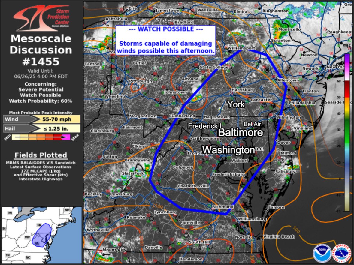
⚠️⁉️ WATCH POSSIBLE Thursday afternoon
Per NOAA discussion….Conditions are favorable for a Severe Thunderstorm Watch to be issued.
💨 Downbursts with damaging wind gusts
DISCUSSION...Thunderstorm activity has begun to initiate across portions of the Appalachians. This activity is expected to continue to expand in coverage through the afternoon/evening.
The environment to the east is hot and unstable (with MLCAPE around 1000-2000 J/kg) and temperatures in the upper 80s to 90s.
Despite the weak flow aloft and weak shear, steep low-level lapse rates (around 7.5-8 C/km) and moist profiles will support potential for wet downbursts and damaging outflow winds. This area will be monitored for watch potential through the afternoon.
The "doomsday plane" is the Boeing E-4B Nightwatch, a modified Boeing 747 used by the U.S. Air Force as a mobile command center for national leaders during emergencies, like nuclear conflicts. It has advanced communication systems, can withstand nuclear blasts, and supports global operations with mid-air refueling. On June 18, 2025, an E-4B flew unexpectedly to D.C., possibly linked to Middle East tensions, though it could be routine. No official confirmation clarifies the purpose, so both scenarios remain plausible.
🌨️NEW ENGLAND SNOW SPECIAL... WINTER STORM ALERTS FOR SATURDAY NIGHT SNOWSTORM
The fast-moving southern slider will put area's just outside #NYC in a moderate snowfall this weekend. I wouldn't be shocked if the cutoff is so dramatic that there is several inches in the #Bronx vs #Brooklyn. #Philadelphia will change over and south of that will be icy! Overall like the idea of 5" min with 7" max totals across much of CT/RI/MA/SE NY/ extreme NNJ
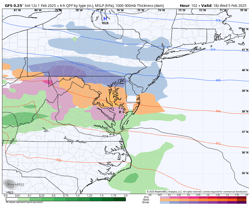
The GFS on an island. Again. If the GFS is correct, there could be a significant snow/ice event in the Baltimore Metro Wednesday next week. 👇 The GEM and Euro say: Nope. Both solutions are possible this far out. Better idea of what's going to happen on Sunday. Stay tuned. ❄️🚂
Good Morning it’s Sunday January 19
‼️ WINTER STORM TODAY: Lots of maps in my report
🌡️ Temps may start above freezing: TURNING COLDER ALL DAY
⏰ Starting 9 AM to Noon; Ending 7 PM to 9 PM (see the timeline animations)
💪 HEAVY SNOW MID AFTERNOON
📏 ❄️ My FINAL CALL FOR SNOWFALL: Compare with Computer Models and NWS
🔗 Full Report: https://t.co/45NvYY6Vc9
🏈 ❄️ REMINDER Eagles game snow in Philadelphia (will fans throw snowballs?); Impact for Ravens Bills Watch Parties
🐻❄️ 🇺🇸: Polar Air Arrives TONIGHT (see the jet stream animation)
⛔️ Cautiously watching Gulf Coast Snow
WEATHER PREDICTIONS:
January 19-20 : A big east coast snow storms drops 6+ inches of snow from dc-boston.
January 22-23: Big southeast snow storm drops record breaking snow in the south and drives up the coast but only hits dc and Philly
#wxtwitter
SUNDAY AFTERNOON UPDATE ON THE SNOW
🚨 ❄️ Snow Emergency Declared in Washington Mon Jan 6
‼️ Winter Storm Warning; ⚠️ Advisory North in Southern PA
⏰ Expected Timeline: Heavy in the morning, a break, then second surge in the evening.
📡 ⏩️ Radar Simulation
💪 ❄️ Heaviest Snow may be between DC, Annapolis, and even close to Baltimore. Less north, more south with some icing.
⛄️ 📏 Compare my snow-cast to new NWS regional maps
🚎 ❄️ Did your school call to close already? Some have…
🥶 🌡️ BITTER COLD TO FOLLOW TUESDAY MORNING
🔗 Full Report https://t.co/DxCFPvW5oy
🥶Prepare for the coldest January in your lifetime🥶
The cold is expected to last much of/the entire month of January.
Here are some things to think about while we have a few days of warmth left…
🧤Get warm clothes!
If you work outside, make sure you have clothes that can keep you warm in 0°F air temperatures with wind chills well below zero.
🧊Check your pipes!
Make sure your water pipes have appropriate insulation to prevent them from freezing. A few dollars spent on insulation could save you thousands of dollars from the damage of a frozen water pipe.
🇨🇭Put a Cold Weather Survival Kit in Your Car
This is potentially the most important piece of advice I can give you if you are traveling. The cold weather we are expecting would be extremely dangerous to find yourself stuck in. Given the potential for some big snow storms in addition to the extreme cold, it is certainly possible that travelers may find themselves in a truly dangerous situation…this applies to everyone, but particularly if you are reading this from an area that does not usually see much cold and snow, like the mid-Atlantic or Southeastern US, you will want to also be prepared.
If you have some other cold weather survival tips that I missed, feel free to leave them in the comments.
#wxtwitter #wxX
Could this be a little overachiever snow?
#Snoverachiever
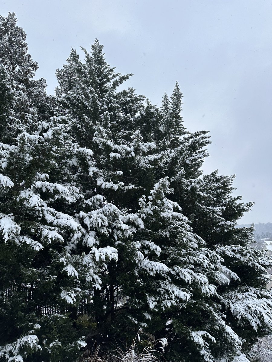
🎄 It already looks pretty for the holiday week! I know there has been stickage in more metro areas now.
🧂 🥶 I recommend salting outside in places that have had #snow, as temps drop below freezing tonight.
📏 Some places near the PA line have already picked up 1 inch of snow (grassy areas) and even more will share snow this evening/tonight.
This developing storm has been tricky and it has expanded and more likely tonight with the coastal storm taking over.
Ironic: Last week the storms had this as a full our snowstorm, then lost it.
Now it’s something in the middle.
🌀 ⏰ It was all about “timing” the energy in the jet stream with the Coastal Storm.
🌡️ ❄️ Tonight will get colder AND there will be more snow forming and pivoting overhead then pulled into the Coastal Low.
📏 There ‘may be’ a surprise coating to 2 inches across parts of the area. I will work on an update this evening.
#FITF
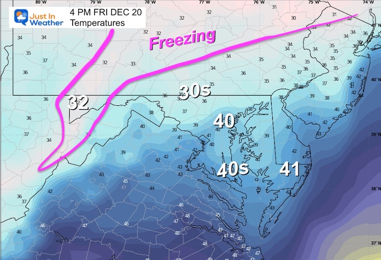
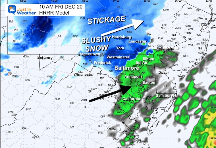
Good Morning it’s Friday December 20
🌧️ ❄️ Slushy Snow Inland/Light Mix or Rain in Metro Areas.
🚗 Road Problems in Central PA and far western MD
📏 ⛄️ Some accumulation (over 2 inches) includes metro Philadelphia
🥶 🏈 🌡️ MUCH COLDER Into This Weekend; Includes Penn State and Ravens Games
🎄 Christmas Eve May Bring Flurries; The Holiday Now Appears To Stay Cold
🔗 Full Report: https://t.co/FKziCNc2Q5
🚨 NEW: Kamala Harris just abruptly cancelled her planned trip to California and “raced to the White House,” per reporters
Biden also just returned to DC, after being expected to stay in Delaware until after Christmas
Is something going on?
Snow On Friday to Saturday Morning
👀 This is a QUICK LOOK at the NAM 3 Km Model (from Thursday morning)
This tends to be a little more aggressive and we see a desiccant switch to snow in the normally colder suburbs North and west... then expanding across Delmarva Friday night to Saturday morning.
❄️ There will be snow falling in metro Baltimore with a mix closer to the Bay.
❄️ There may be some minor accumulation in the northern suburbs.
🌡️ Temps will be near or just above freezing in the suburbs. Any road stickage will be limited... then more likely after 3 PM and after dark.
❄️ 📏 More measurable snow North AND East... This may include Cecil County Maryland to Metro Philadelphia
🏈 Also across Central Pennsylvania to consider if you are driving to Penn State for the Saturday game.
🏔️ The mountains will have stickage on the roads.
Delmarva may wake up to a few hours of snow Saturday morning.
📝 I will have a more complete report later.