The last time one of these were issued, it also combined with Spring Tides (which are currently ongoing), we saw Maracas Bay (the parking facility and North Coast Road) flood, Pigeon Point Jetty was damaged, and coastal flooding occurred in Mayaro.
A significant long-period swell event is forecast to begin tonight with T&T's second-ever Orange-Level Hazardous Seas Alert issued for T&T.
Large, battering waves are likely along T&T's northern and northeastern coastlines. The TTMS is advising the public to "Restrict nearshore marine activities."
https://t.co/IpeJpkJ9In
Wind direction (and shower/thunderstorm movement) are going to be *very* variable through next week. Look at these wind shifts at Piarco over the last 3 hours.
An Adverse Weather Alert is in effect for T&T through noon tomorrow. Still, conditions for heavy early morning rains, hot mid-mornings, and then late morning/afternoon intense rainfall remain daily through *checks calendar* September 10th!
An Adverse Weather Alert has been issued for Trinidad due to several weather features interacting through 9 AM Thursday.
Locally heavy rainfall, gusty winds up to 55 KM/H, and street/flash flooding are all possible, favoring the southern &western halves of Trinidad.
https://t.co/OU4JxlSUrb
4:00 AM - Scattered showers and isolated thunderstorms continue to develop and remain short-lived across Trinidad and Tobago, producing thunder, lightning, and locally heavy rainfall.
Rain, showers, and thunderstorms are forecast across both islands through this afternoon, with locally intense rainfall likely to produce street/flash flooding, particularly across central and northern areas, accompanied by gusty winds.
Forecast: https://t.co/p1skOduVoa
Between Tuesday and Thursday this week, periods of rain, isolated to scattered showers and thunderstorms are forecast to affect T&T.
Many hazards are in the forecast - from strong gusty winds, street/flash flooding, and landslides.
Forecast: https://t.co/Frbf6VAiDq
Elevated levels of #SaharanDust are forecast to return from tomorrow (Saturday) across T&T, lingering through the end of July.
Sensitive groups are advised to take the necessary precautions, particularly this weekend.
https://t.co/ESEGiOzhbR
The Adverse Weather Alert has been extended to all of Trinidad and Tobago and will remain in effect until 8:00 PM today.
Gusty winds, street/flash flooding, agitated seas, and landslides are all possible due to heavy showers and thunderstorms today.
https://t.co/rPl9aYTfsO
TRAFFIC ALERT (1:20 PM) - All eastbound lanes of the Churchill Roosevelt Highway past Orange Grove, Trincity, are flooded, with the right two lanes passable at this time.
Expect significant traffic delays. Up to 3 inches of rain (75 mm) has fallen in the area over the last 1.5 hours.
https://t.co/CaxsTkaYxu
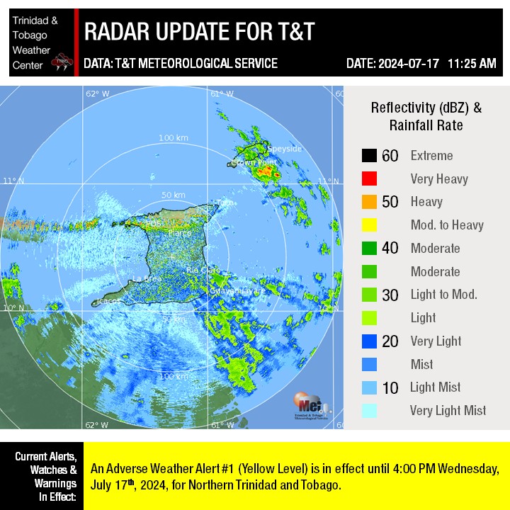
11:25 AM - Moderate to heavy showers and isolated thunderstorms are affecting Tobago.
Across Trinidad, as forecast, cloudy conditions are increasing across central and northern Trinidad while southern areas remain mostly sunny.
Showers and thunderstorms are likely to develop across central and northern areas of Trinidad mainly after midday, intensifying along western coastal Trinidad and south-facing slopes of the Central and Northern Range.
For southern areas, showers and thunderstorms are likely to return later this afternoon, moving in from the southeast.
Gusty winds up to 50 KM/H are possible in heavy rainfall, with street/flash flooding likely. Landslides are possible across elevated areas of Northern Trinidad and windward-facing slopes of Tobago.
https://t.co/dNkI8ouIsr
3:00 AM - Flooding ongoing across Lower Barrackpore as rains temporarily subside. Heavy rainfall is now ongoing across southeastern Trinidad, with rainfall set to spread across southern areas in the coming hours.
#TurnAroundDontDrown
https://t.co/YiuqObuM7L
According to the University of the West Indies Seismic Research Center (UWI SRC), a burst of volcanic earthquakes was recorded beneath northern Dominica from 12:45 AM on Tuesday, July 16th, 2024.
https://t.co/M0pEhw7OtV
🌀BREAKING: At least 1 person has died in St. Vincent and the Grenadines, the prime minister said following the passage of Hurricane Beryl.
PM Gonsalves says there may be more fatalities.
The Met Office has announced that with immediate effect, the Hurricane Warning for Tobago has been downgraded to a Tropical Storm Warning and the Tropical Storm Warning for Trinidad has been discontinued with an Adverse Weather Alert - Orange Level taking its place.
A series of weather features are forecast to affect T&T over the next five days:
Friday/Saturday: The ITCZ and Tropical Wave 15
Sunday: Saharan Dust & approach of Invest #95L
Monday: Passage of the low-pressure system associated with Invest #95L north of T&T
Tuesday: Trailing convergence, then Saharan Dust (again)
Wednesday: Another Tropical Disturbance passing nearby.
Our Five-Day Forecast: https://t.co/vczKiXmuwT
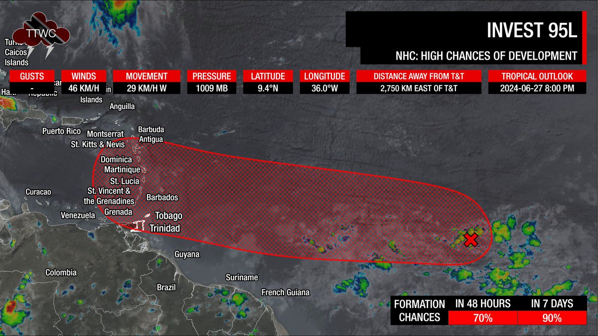
8:00 PM - Invest #95L chances of development have increased once more, with the National Hurricane Center giving the disturbance a high chance of formation over the next seven days.
For T&T, the forecast remains mostly unchanged, with most of the intense weather remaining north of the country on Monday.
T&T's main hazards will originate from feeder bands, rough seas mainly north of T&T, and northward moving thunderstorms Monday night through Tuesday, producing frequent lightning and locally heavy rainfall.
Read more: https://t.co/wzKzZizS7Z
Trinidad and Tobago is under an Adverse Weather Alert.
The TTMS issued it at 6:14 AM and went into effect for the country at 6:20 AM amidst heavy rainfall ongoing since midnight. The alert is in effect until 2:00 PM today.
Details: https://t.co/xAGvxROjZQ