#mbstorm 12:40p WIND WARNING (YELLOW LEVEL) ENDED by Environment Canada
(Locations listed below description)
Damaging winds are no longer expected.
ENDED:
- Gillam
- Island Lake
- Oxford House and Gods Lake
- Red Sucker Lake
- Shamattawa
#mbstorm 5:32a WINTER STORM WARNING (YELLOW LEVEL) ENDED by Environment Canada
ENDED:
- Brochet
- Leaf Rapids
- Lynn Lake
- Pukatawagan
- South Indian Lake and Amisk Prov. Park
#mbstorm 5:32a WINTER STORM WARNING (YELLOW LEVEL) UPDATED by Environment Canada
DATE: Sunday, October 25, 2026
(Locations listed below description)
Impact level: Moderate
Forecast confidence: High
A significant fall storm continues to impact northern Manitoba early Sunday morning.
Where: Tadoule Lake
What: Hazardous winter conditions including: Heavy snow with total amounts of 20 to 40 cm severe wind gusts up to 90 km/h significantly reduced visibilities in blowing snow freezing rain with total amounts of 5 to 10 mm heavy rain with total amounts of 20 to 30 mm
When: Snow and local blowing snow continue early this morning over northern Manitoba. Visibilities will improve throughout the morning as winds diminish and snowfall tapers off.
Travel will likely be hazardous. Visibility will likely be suddenly reduced to near-zero at times. Property damage is possible. Property or tree damage is possible.
Please continue to monitor alerts and forecasts issued by Environment Canada. To report severe weather, send an email to [email protected], call 1-800-239-0484 or post reports on social media using #MBStorm.
UPDATED:
- Tadoule Lake
#mbstorm 4:33a WIND WARNING (YELLOW LEVEL) ENDED by Environment Canada
ENDED:
- Cross Lake and Jenpeg
- Hwy 6 between Little Limestone Lake and Ponton
- Molson Lake and Bear Lake
- North and South Moose Lake incl. Moose Lake Res.
- Norway House
- The Pas Cormorant Westray and Wanless
- Wabowden
#mbstorm 4:33a WIND WARNING (YELLOW LEVEL) UPDATED by Environment Canada
DATE: Sunday, October 25, 2026
(Locations listed below description)
Impact level: Moderate
Forecast confidence: High
Damaging winds are expected.
A low pressure system moving through northern Manitoba will bring strong westerly wind gusts up to 100 km/h to communities in northeastern Manitoba beginning Saturday evening.
The wind gusts will weaken from West to East, with winds diminishing in Western regions late Saturday evening and diminishing over eastern areas early Sunday morning.
Local utility outages are possible. Damage to roofs, fences, branches or soft shelters is possible.
Wind warnings are issued when there is a significant risk of damaging winds.
Please continue to monitor alerts and forecasts issued by Environment Canada. To report severe weather, send an email to [email protected], call 1-800-239-0484 or post reports on social media using #MBStorm.
UPDATED:
- Gillam
- Island Lake
- Oxford House and Gods Lake
- Red Sucker Lake
- Shamattawa
- York
#mbstorm 3:50a WINTER STORM WARNING (YELLOW LEVEL) UPDATED by Environment Canada
DATE: Sunday, October 25, 2026
(Locations listed below description)
Impact level: Moderate
Forecast confidence: High
A significant fall storm continues to impact northern Manitoba and the kivalliq on Sunday.
Where: Churchill and Arviat
What: Hazardous winter conditions including: Snow with total amounts of 10 to 25 cm severe wind gusts possibly up to 100 km/h significantly reduced visibilities in blowing snow rain with total amounts of 20 to 30 mm
When: Beginning Saturday morning and tapering off Sunday afternoon
Remarks: Snow and blowing snow continue Sunday morning. Very strong winds will occur also, with gusts up to 100 km/h possible, with drastically reduced visibilities in blowing snow. Snow and winds will gradually taper off Sunday afternoon.
Travel will likely be hazardous. Visibility will likely be suddenly reduced to near-zero at times. Local utility outages are likely. High-sided vehicles will be pushed around by the wind. Prepare for quickly changing and deteriorating travel conditions. Secure loose objects.
Please continue to monitor alerts and forecasts issued by Environment Canada. To report severe weather, send an email to [email protected], call 1-800-239-0484 or post reports on social media using #MBStorm.
UPDATED:
- Churchill
#mbstorm 10:24p WIND WARNING (YELLOW LEVEL) ISSUED by Environment Canada
DATE: Saturday, October 24, 2026
(Locations listed below description)
Impact level: Moderate
Forecast confidence: High
Damaging winds are expected.
A low pressure system moving through northern Manitoba tonight will bring strong westerly wind gusts up to 100 km/h to communities in Central and northeastern Manitoba beginning this evening.
The wind gusts will weaken from West to East, with winds diminishing in Western regions later this evening and diminishing over eastern areas early Sunday morning.
Local utility outages are possible. Damage to roofs, fences, branches or soft shelters is possible.
Wind warnings are issued when there is a significant risk of damaging winds.
Please continue to monitor alerts and forecasts issued by Environment Canada. To report severe weather, send an email to [email protected], call 1-800-239-0484 or post reports on social media using #MBStorm.
NEW:
- Cross Lake and Jenpeg
- Gillam
- Hwy 6 between Little Limestone Lake and Ponton
- Island Lake
- Molson Lake and Bear Lake
- North and South Moose Lake incl. Moose Lake Res.
- Norway House
- Oxford House and Gods Lake
- Red Sucker Lake
- Shamattawa
- The Pas Cormorant Westray and Wanless
- Wabowden
- York
#mbstorm 6:43p WIND WARNING (YELLOW LEVEL) ENDED by Environment Canada
(Locations listed below description)
Damaging winds are no longer expected.
ENDED:
- Mun. of Ethelbert incl. Garland
- R.M. of Dauphin incl. Sifton and Valley River
- R.M. of Lakeshore incl. Ochre River and Makinak
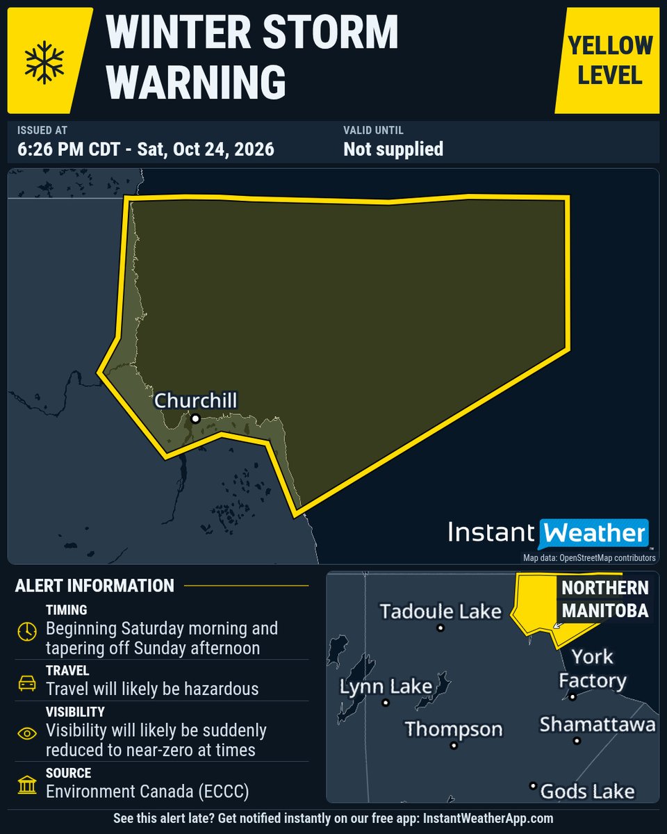
#mbstorm 6:26p WINTER STORM WARNING (YELLOW LEVEL) UPDATED by Environment Canada
DATE: Saturday, October 24, 2026
(Locations listed below description)
Impact level: Moderate
Forecast confidence: High
A significant fall storm will continue to impact northern Manitoba and the kivalliq through the weekend.
Where: Churchill and Arviat
What: Hazardous winter conditions including: Snow with total amounts of 10 to 25 cm severe wind gusts possibly exceeding 110 km/h. Significantly reduced visibilities in blowing snow. Rain with total amounts of 20 to 30 mm.
When: Beginning Saturday morning and tapering off Sunday afternoon.
Remarks: Precipitation will begin in this area today as rain or freezing rain before transitioning to snow and blowing snow this evening and overnight. Very strong winds will occur also, with gusts up to a possibly 100 to 110 km/h, with drastically reduced visibilities in blowing snow. Snow and winds will gradually taper off Sunday afternoon.
Travel will likely be hazardous. Visibility will likely be suddenly reduced to near-zero at times. Local utility outages are likely. High-sided vehicles will be pushed around by the wind. Prepare for quickly changing and deteriorating travel conditions. Secure loose objects.
Please continue to monitor alerts and forecasts issued by Environment Canada. To report severe weather, send an email to [email protected], call 1-800-239-0484 or post reports on social media using #MBStorm.
UPDATED:
- Churchill
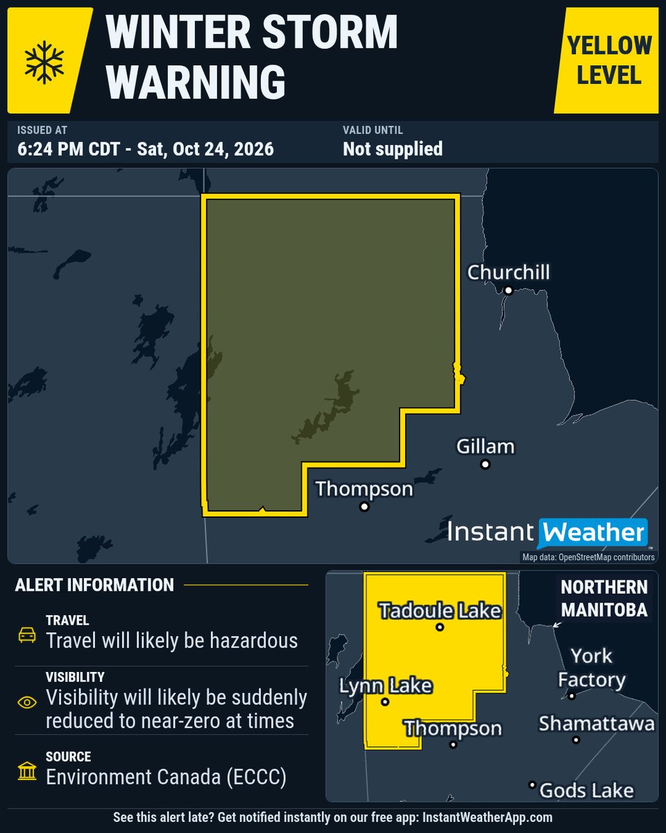
#mbstorm 6:24p WINTER STORM WARNING (YELLOW LEVEL) UPDATED by Environment Canada
DATE: Saturday, October 24, 2026
(Locations listed below description)
Impact level: Moderate
Forecast confidence: High
A significant fall storm will continue to impact northern Manitoba through the weekend.
Where: Areas of northern Manitoba, including, Pukatawagan, Lynn Lake, Brochet, and Tadoule Lake.
What: Hazardous winter conditions including: Heavy snow with total amounts of 20 to 40 cm. Severe wind gusts exceeding 90 km/h. Significantly reduced visibilities in blowing snow. Freezing rain with total amounts of 5 to 10 mm. Heavy rain with total amounts of 20 to 30 mm.
When: Rain and freezing rain developed overnight over northern Manitoba. This will transition to snow throughout the day before tapering off Sunday afternoon. Winds will strengthen throughout the day with gusts up to 90 km/h in areas closer to the Nunavut border and will taper off Sunday afternoon and evening. Visibilities will be drastically reduced in blowing snow this afternoon and evening when falling snow and strong winds combine.
Travel will likely be hazardous. Visibility will likely be suddenly reduced to near-zero at times. Property damage is possible. Property or tree damage is possible.
Please continue to monitor alerts and forecasts issued by Environment Canada. To report severe weather, send an email to [email protected], call 1-800-239-0484 or post reports on social media using #MBStorm.
UPDATED:
- Brochet
- Leaf Rapids
- Lynn Lake
- Pukatawagan
- South Indian Lake and Amisk Prov. Park
- Tadoule Lake
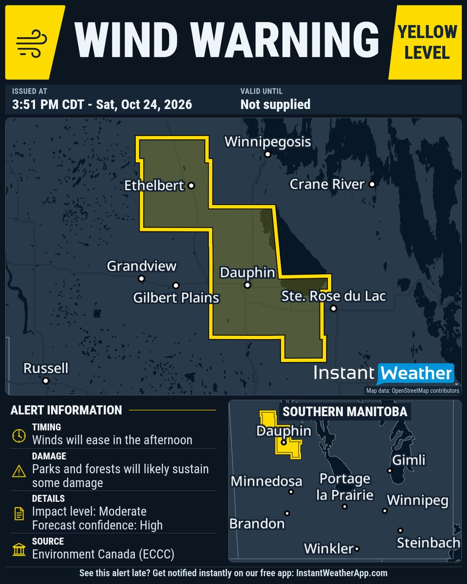
#mbstorm 3:51p WIND WARNING (YELLOW LEVEL) UPDATED by Environment Canada
DATE: Saturday, October 24, 2026
(Locations listed below description)
Impact level: Moderate
Forecast confidence: High
Strong West winds coming down Riding Mountain may have severe wind gusts up to 100 km/h at times on Saturday morning. Winds will ease in the afternoon.
High-sided vehicles will be pushed around by the wind. Parks and forests will likely sustain some damage.
Please continue to monitor alerts and forecasts issued by Environment Canada. To report severe weather, send an email to [email protected], call 1-800-239-0484 or post reports on social media using #MBStorm.
UPDATED:
- Mun. of Ethelbert incl. Garland
- R.M. of Dauphin incl. Sifton and Valley River
- R.M. of Lakeshore incl. Ochre River and Makinak
#mbstorm 2:06p WIND WARNING (YELLOW LEVEL) UPDATED by Environment Canada
DATE: Saturday, October 24, 2026
(Locations listed below description)
Impact level: Moderate
Forecast confidence: High
Strong West winds coming down Riding Mountain may have severe wind gusts up to 100 km/h at times on Saturday morning. Winds will ease in the afternoon.
High-sided vehicles will be pushed around by the wind. Parks and forests will likely sustain some damage.
Please continue to monitor alerts and forecasts issued by Environment Canada. To report severe weather, send an email to [email protected], call 1-800-239-0484 or post reports on social media using #MBStorm.
UPDATED:
- Mun. of Ethelbert incl. Garland
- Mun. of Glenella-Lansdowne incl. Arden and Tenby
- Mun. of McCreary incl. Norgate
- Mun. of Ste. Rose incl. Laurier
- R.M. of Dauphin incl. Sifton and Valley River
- R.M. of Lakeshore incl. Ochre River and Makinak
#mbstorm 8:42a WIND WARNING (YELLOW LEVEL) UPDATED by Environment Canada
(Locations listed below description)
Strong west winds coming down Riding Mountain may have severe wind gusts up to 100 km/h at times on Saturday morning. Winds will ease in the afternoon.
High-sided vehicles will be pushed around by the wind. Parks and forests will likely sustain some damage.
Please continue to monitor alerts and forecasts issued by Environment Canada. To report severe weather, send an email to [email protected], call 1-800-239-0484 or post reports on social media using #MBStorm.
UPDATED:
- Mun. of Ethelbert incl. Garland
- Mun. of Glenella-Lansdowne incl. Arden and Tenby
- Mun. of McCreary incl. Norgate
- Mun. of Ste. Rose incl. Laurier
- R.M. of Dauphin incl. Sifton and Valley River
- R.M. of Lakeshore incl. Ochre River and Makinak
#mbstorm 7:13a WIND WARNING (YELLOW LEVEL) UPDATED by Environment Canada
(Locations listed below description)
Strong west winds coming down Riding Mountain may have severe wind gusts up to 100 km/h at times on Saturday morning. Winds will ease in the afternoon.
High-sided vehicles will be pushed around by the wind. Parks and forests will likely sustain some damage.
Please continue to monitor alerts and forecasts issued by Environment Canada. To report severe weather, send an email to [email protected], call 1-800-239-0484 or post reports on social media using #MBStorm.
UPDATED:
- Mun. of Glenella-Lansdowne incl. Arden and Tenby
- Mun. of McCreary incl. Norgate
#mbstorm 7:13a WIND WARNING (YELLOW LEVEL) ISSUED by Environment Canada
(Locations listed below description)
High-sided vehicles will be pushed around by the wind. Parks and forests will likely sustain some damage.
Please continue to monitor alerts and forecasts issued by Environment Canada. To report severe weather, send an email to [email protected], call 1-800-239-0484 or post reports on social media using #MBStorm.
NEW:
- Mun. of Glenella-Lansdowne incl. Arden and Tenby
- Mun. of McCreary incl. Norgate
#mbstorm 5:25a WINTER STORM WARNING (YELLOW LEVEL) UPDATED by Environment Canada
A significant fall storm will continue to impact northern Manitoba and the Kivalliq today and will persist through the weekend.
Where: Churchill and Arviat
What: Hazardous winter conditions including:
Snow with total amounts of 10 to 25 cm
Severe wind gusts possibly exceeding 110 km/h.
Significantly reduced visibilities in blowing snow.
Rain with total amounts of 20 to 30 mm.
When: Beginning Saturday morning and tapering off Sunday afternoon.
Remarks: Precipitation will begin in this area today as rain or freezing rain before transitioning to snow and blowing snow this evening and overnight. Very strong winds will occur also, with gusts up to a possibly 100 to 110 km/h, with drastically reduced visibilities in blowing snow. Snow and winds will gradually taper off Sunday afternoon.
Travel will likely be hazardous. Visibility will likely be suddenly reduced to near-zero at times. Local utility outages are likely. High-sided vehicles will be pushed around by the wind.
Prepare for quickly changing and deteriorating travel conditions. Secure loose objects.
Please continue to monitor alerts and forecasts issued by Environment Canada. To report severe weather, send an email to , call 1-800-239-0484 or post reports on social media using #MBStorm.
Churchill
#mbstorm 4:42a WINTER STORM WARNING (YELLOW LEVEL) UPDATED by Environment Canada
(Locations listed below description)
A significant fall storm will continue to impact northern Manitoba today and will persist through the weekend.
Where: Areas of northern Manitoba, including, Pukatawagan, Lynn Lake, Brochet, and Tadoule Lake.
What: Hazardous winter conditions including:
Heavy snow with total amounts of 20 to 40 cm.
Severe wind gusts exceeding 90 km/h.
Significantly reduced visibilities in blowing snow.
Freezing rain with total amounts of 5 to 10 mm.
Heavy rain with total amounts of 20 to 30 mm.
When: Rain and freezing rain developed overnight over northern Manitoba. This will transition to snow throughout the day before tapering off Sunday afternoon. Winds will strengthen throughout the day with gusts up to 90 km/h in areas closer to the Nunavut border and will taper off Sunday afternoon and evening. Visibilities will be drastically reduced in blowing snow this afternoon and evening when falling snow and strong winds combine.
Travel will likely be hazardous. Visibility will likely be suddenly reduced to near-zero at times. Property damage is possible. Property or tree damage is possible.
Please continue to monitor alerts and forecasts issued by Environment Canada. To report severe weather, send an email to [email protected], call 1-800-239-0484 or post reports on social media using #MBStorm.
UPDATED:
- Brochet
- Leaf Rapids
- Lynn Lake
- Pukatawagan
- South Indian Lake and Amisk Prov. Park
- Tadoule Lake
#mbstorm 8:37p WINTER STORM WARNING (YELLOW LEVEL) UPDATED by Environment Canada
(Locations listed below description)
A significant fall storm will impact northeastern Manitoba and the southern Kivalliq beginning saturday and will persist through the weekend.
Where: Churchill and Arviat
What: Hazardous winter conditions including:
Snow with total amounts of 10 to 25 cm
Severe wind gusts possibly exceeding 110 km/h.
Significantly reduced visibilities in blowing snow.
Rain with total amounts of 20 to 30 mm.
When: Beginning Saturday morning and tapering off Sunday afternoon.
Remarks: Precipitation will move into this area on Saturday as rain or wet snow as wind off the bay will keep temperatures at or above zero. At this time, wind speeds will increase will gusts up to 100 km/h. Conditions will transition to snow and blowing snow in the evening and overnight with wind gusts possibly exceeding 110 km/h and drastically reduced visibilities. Snow and winds will gradually taper off Sunday afternoon.
Travel will likely be hazardous. Visibility will likely be suddenly reduced to near-zero at times. Local utility outages are likely. High-sided vehicles will be pushed around by the wind.
Prepare for quickly changing and deteriorating travel conditions. Secure loose objects.
Please continue to monitor alerts and forecasts issued by Environment Canada. To report severe weather, send an email to [email protected], call 1-800-239-0484 or post reports on social media using #MBStorm.
UPDATED:
- Churchill