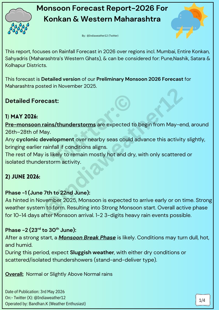
☔️🌧 👉 Detailed Monsoon 2026 Forecast Report for (May-June-July-August-September-October) for entire Konkan Belt incl. (#Mumbai, #Palghar, #Thane, #Raigad, #Ratnagiri, #Sindhudurg) & can be considered for #Pune, #Satara #Nashik #Kolhapur
This forecast is Detailed version of our Preliminary Monsoon 2026 Forecast for Maharashtra posted in November 2025.
Detailed Forecast:
1) May 2026:
Pre-monsoon rains/thunderstorms are expected to begin from May-end, around 26th–28th of May.
Any cyclonic development over nearby seas could advance this activity slightly, bringing earlier rainfall if conditions aligns.
The rest of May is likely to remain mostly hot and dry, with only scattered or isolated thunderstorm activity.
2) JUNE 2026:
Phase -1 (June 7th to 22nd June):
As hinted in November 2025, Monsoon is expected to arrive early or on time. Strong weather system to form. Resulting into Strong Monsoon start. Overall active phase for 10-14 days after Monsoon arrival. 1-2 3-digits heavy rain events possible.
Phase -2 (23rd to 30th June):
After a strong start, a Monsoon Break Phase is likely. Conditions may turn dull, hot, and humid.
During this period, expect Sluggish weather, with either dry conditions or scattered/isolated thundershowers (stand-and-deliver type).
Overall: Normal or Slightly Above Normal rains
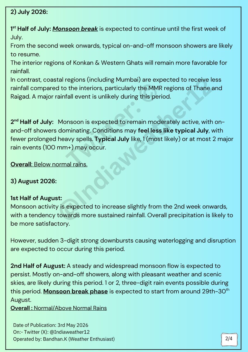
2) July 2026:
1st Half of July: Monsoon break is expected to continue until the first week of July.
From the second week onwards, typical on-and-off monsoon showers are likely to resume.
The interior regions of Konkan & Western Ghats will remain more favorable for rainfall.
In contrast, coastal regions (including Mumbai) are expected to receive less rainfall compared to the interiors, particularly the MMR regions of Thane and Raigad. A major rainfall event is unlikely during this period.
2nd Half of July: Monsoon is expected to remain moderately active, with on-and-off showers dominating. Conditions may feel less like typical July, with fewer prolonged heavy spells. Typical July like, 1 (most likely) or at most 2 major rain events (100 mm+) may occur.
Overall: Below normal rains.
3) August 2026:
1st Half of August:
Monsoon activity is expected to increase slightly from the 2nd week onwards, with a tendency towards more sustained rainfall. Overall precipitation is likely to be more satisfactory.
However, sudden 3-digit strong downbursts causing waterlogging and disruption are expected to occur during this period.
2nd Half of August: A steady and widespread monsoon flow is expected to persist. Mostly on-and-off showers, along with pleasant weather and scenic skies, are likely during this period. 1 or 2, three-digit rain events possible during this period. Monsoon break phase is expected to start from around 29th-30th August.
Overall : Normal/Above Normal Rains
4) Septmeber 2026:
Phase 1 : Monsoon break phase to continue until around 9th–11th of September. The monsoon trough will remain over the foothills of the Himalayas. Sluggish weather with mostly hot & humid conditions is expected.
Scattered/isolated stand-and-deliver thundershowers are expected during this period.
Phase-2 : A strong comeback of Monsoon is possible from around 12th–14th September. A strong system is expected to form in the Bay of Bengal (BoB), which will pull the monsoon trough towards central India.
This event coincides with Ganesh Utsav, so significant rainfall is likely during the festive days.
A very active and wet Monsoon phase is expected. Daily rainfall is likely during this period. 2–3 disruptive, triple-digit heavy rainfall events are possible.
Phase 3: From around 27th–28th September, rainfall will start reducing significantly. Rainfall will shift to convective thundershowers. One day of heavy rain during this period cannot be ruled out.
Overall: Normal or Above normal rains (due to active 2nd phase)
#MumbaiRains #PuneRains #PuneRain #MumbaiRain #MumbaiWeather
🌦️ Weather Forecast for the Next 4 Days (13th June to 16th June) across Konkan & Western Maharashtra🌴🌦️
Including #MumbaiRains & #PuneRains
Dry air will continue to dominate weather conditions across the region over the next few days. A #UAC along the trough is expected to develop over the Bay of Bengal, but it is unlikely to have any significant impact on Maharashtra.
🌊🌴 Konkan, including #Mumbai, will continue to experience hot and humid weather. Moist low-level westerly winds from the Arabian Sea will occasionally bring isolated showers and clouds, but widespread rainfall is not expected.
🌦️ Western Maharashtra, including #Pune, will continue to remain warm and humid during the day. However, nights and early mornings should remain comparatively more pleasant than the coastal belt. A persistent layer of dry air in the mid-levels of the atmosphere, combined with the absence of any strong lifting mechanism, will continue to suppress Thunderstorm activity across most parts of the region.
Few Isolated showers 🌦 especially towards Ghat regions of Western MH are possible due to low level westerlies.
A monsoon revival is possible during the 4th week of June. Further details on this potential surge, along with an analysis of why the monsoon has slowed down, will be covered in upcoming post. 🌧
🥵 Hot, humid and uncomfortable weather continues across Konkan and Western Maharashtra. No signs of significant #MumbaiRains or #PuneRains for next several days.
The latest satellite imagery clearly shows dry air dominating the mid-levels of the atmosphere, while persistent low-level westerlies continue feeding moisture from the Arabian Sea into the region.
🌊 However, most of this moisture remains trapped near the surface. This is leading to very humid and uncomfortable conditions across the region, with the air feeling heavy and sticky throughout the day.
⛰️ The Sahyadris are further helping trap this moisture along the Konkan coast. The resulting low clouds and humid air act like a blanket, preventing efficient cooling after sunset. This effect amplifies in Mumbai, where dense urbanization, industrial emissions, concrete structures, traffic and AC exhaust add to the heat buildup, making nights feel unusually warm and muggy.
🌄 Across Western Maharashtra, daytime conditions are also turning humid and uncomfortable due to the persistent inflow of Arabian Sea moisture. However, the plateau region generally cools more efficiently after sunset than the coastal belt, as heat can escape more freely and moisture is not trapped as strongly as along the coast.
No relief seen for atleast next 4-5 days. A Low pressure is required over the Bay of Bengal to cleanup this dry air and to wake up Monsoon surge along the west coast.
🌦️ Weather Forecast for next 3 days (10th June to 12th June) across Konkan & Western Maharashtra along with #MumbaiRains & #PuneRains probability. 🌴🌦️
🌊 Arabian Sea Monsoon current has started losing its strength. Due to which Monsoon progress will stall for next few days. The absence of any significant system over Bay of Bengal, along with weakening Monsoon current and frequent unusually southward dipping WD troughs, has paved the way for large-scale continental dry air intrusion from Northwest India. 🌵💨
☁️ With cloud growth already struggling due to a weak Monsoon current, this additional dry air intrusion will make matters worse by further suppressing convection and rainfall development. These dry mid-level winds will further hinder the already weak cloud growth, causing rainfall activity to gradually shrink and get pushed further southward with each passing day. ⬇️🌧️
🌤️ Thus, #Nashik and #Pune districts along with #Pune city will remain mostly dry. A few isolated showers might show up near the Ghats of these districts. ⛰️🌦️
🌦️ #Satara and #Kolhapur might receive isolated spells at a few places until tomorrow. Thereafter, conditions are expected to remain mostly dry, except some parts of southern Kolhapur and adjoining South Konkan which may continue to receive an odd shower or two. 🌴🌧️
🥵💦 #Mumbai and MMR regions, #Palghar and #Thane districts will continue to remain hot and humid with no major signs of relief. A significant Bay of Bengal system will likely be required to pull meaningful rainfall into the region and revive Monsoon activity. 🌊🌀☔
🌦️ A few isolated short-duration showers might show up until tomorrow, after which even these are expected to reduce significantly or disappear altogether. ☁️➡️☀️
🌴🌦️ #Raigad and #Ratnagiri will mostly receive light showers with an odd moderate spell at isolated places. Rainfall probability increases as we move southwards. However, the overall rain spread is expected to gradually shift southward with each passing day. ⬇️🌧️
🌧️🌴 #Sindhudurg is likely to receive light to moderate showers. However, rainfall coverage and spread are expected to keep reducing day by day as dry northwesterly winds continue pushing the rains southwards. 🌵💨⬇️🌧️
☔📉 Overall, the next 3 days are expected to be dominated by weakening Monsoon currents, suppressed cloud growth and increasing dry air intrusion, resulting in shrinking rainfall coverage and a gradual southward retreat of rain activity across Konkan & Western Maharashtra. 🌴🌧️
Chart Credits: https://t.co/yjQ1BLdsnn, GFS
🌧️🌴 #Monsoon Covers most of Ratnagiri District; #MumbaiRains May Have to Wait a Little Longer.
🌧️🌴 As expected, Monsoon has covered almost the entire Ratnagiri district and now the Northern Limit of Monsoon in Maharashtra is passing through Harnai–Solapur. 🇮🇳
✅ Conditions remain favourable for further advance during the next 24–48 hours.
⏳ Thereafter, a slowdown or temporary halt in Monsoon progress is expected before the next phase of advancement. 🌦️📉
With advancing Monsoon current, isolated showers were recorded over Mumbai today.
🌦 North Konkan and #Mumbai to remain unfavorable for any significant rains. Check Forecast Below.
🌴🌧️ #Monsoon Update with Rain Forecast for Konkan & Western Maharashtra incl. #MumbaiRains & #PuneRains
Yesterday, Monsoon covered the remaining parts of Goa and entered Sindhudurg district, marking an on-time arrival over the region. 🌧️✅
It is expected to advance further over #Ratnagiri district and parts of Raigad district during the next 24 to 72 hours before the current surge starts weakening.
⚠️ From around 10th June, a temporary slowdown or halt in Monsoon progress is expected due to strengthening continental dry air intrusion from Northwest. North Konkan, including #Mumbai, lies exactly in its zone and may either miss the onset from the current surge or receive a weak onset declaration by IMD depending upon fulfillment of the required criteria on or before 10th June.
Thus, North Konkan and adjoining parts of Western Maharashtra may have to wait for the next surge for the actual Monsoon onset, which currently appears likely around 14th–15th June. 🌦️
Thereafter, the rainfall strength will largely depend on the formation of weather systems over the basins. Models continue to remain volatile regarding this aspect and close monitoring is required over the next few days. 🌀 A single favourable Low Pressure Area over the basins can make a huge difference and may easily help the Monsoon surge overcome the dry air intrusion.
Meanwhile, #Premonsoon thunderstorm activity is expected to increase from today until 9th June. ⛈️ East & South Pune district, Satara, Kolhapur, Raigad and Ratnagiri districts will remain the most favourable regions for thunderstorm development.
However, the remaining parts of Pune district and North Konkan including #Mumbai will remain on the edge of this activity. Isolated thunderstorm pop-ups ⛈️ may develop over these regions. Some isolated showers during midnight night and morning hours 🌦 may also show up over Coastal regions incl.#Mumbai, while most areas are expected to remain dry.
#Monsoon2026 #MaharashtraWeather
Chart Credits: https://t.co/yjQ1BLdsnn,ECMWF & GFS
🌧️ #Monsoon Makes Rapid Progress; Arabian Sea Branch Back on Track! 🌴🌦️
Another long jump by Monsoon and today it has covered Entire Coastal Karnataka and most parts of South Interior Karnataka. It has also entered in South Goa.
In just 2 days, the Monsoon has covered entire Keralam, almost half of Karnataka, parts of Tamil Nadu and South Goa. 👌 With this, the Arabian Sea branch of Monsoon is now running on time.
Conditions remain favourable for its further advance into the remaining parts of Goa, South Konkan and adjoining parts of Kolhapur district during the next 24–48 hours. 🌦️
Widespread Monsoon rains are currently unleashing over the regions where Monsoon has arrived, while dense monsoon clouds can be seen throughout the coastal belt. 🌧️☁️
Widespread rains over these regions are expected to continue further, while South Konkan is expected to join the party soon, resulting in a robust start to the Monsoon season. 🌴⛈️
☔️🌧 👉 Detailed Monsoon 2026 Forecast Report for (May-June-July-August-September-October) for entire Konkan Belt incl. (#Mumbai, #Palghar, #Thane, #Raigad, #Ratnagiri, #Sindhudurg) & can be considered for #Pune, #Satara #Nashik #Kolhapur
This forecast is Detailed version of our Preliminary Monsoon 2026 Forecast for Maharashtra posted in November 2025.
Detailed Forecast:
1) May 2026:
Pre-monsoon rains/thunderstorms are expected to begin from May-end, around 26th–28th of May.
Any cyclonic development over nearby seas could advance this activity slightly, bringing earlier rainfall if conditions aligns.
The rest of May is likely to remain mostly hot and dry, with only scattered or isolated thunderstorm activity.
2) JUNE 2026:
Phase -1 (June 7th to 22nd June):
As hinted in November 2025, Monsoon is expected to arrive early or on time. Strong weather system to form. Resulting into Strong Monsoon start. Overall active phase for 10-14 days after Monsoon arrival. 1-2 3-digits heavy rain events possible.
Phase -2 (23rd to 30th June):
After a strong start, a Monsoon Break Phase is likely. Conditions may turn dull, hot, and humid.
During this period, expect Sluggish weather, with either dry conditions or scattered/isolated thundershowers (stand-and-deliver type).
Overall: Normal or Slightly Above Normal rains
2) July 2026:
1st Half of July: Monsoon break is expected to continue until the first week of July.
From the second week onwards, typical on-and-off monsoon showers are likely to resume.
The interior regions of Konkan & Western Ghats will remain more favorable for rainfall.
In contrast, coastal regions (including Mumbai) are expected to receive less rainfall compared to the interiors, particularly the MMR regions of Thane and Raigad. A major rainfall event is unlikely during this period.
2nd Half of July: Monsoon is expected to remain moderately active, with on-and-off showers dominating. Conditions may feel less like typical July, with fewer prolonged heavy spells. Typical July like, 1 (most likely) or at most 2 major rain events (100 mm+) may occur.
Overall: Below normal rains.
3) August 2026:
1st Half of August:
Monsoon activity is expected to increase slightly from the 2nd week onwards, with a tendency towards more sustained rainfall. Overall precipitation is likely to be more satisfactory.
However, sudden 3-digit strong downbursts causing waterlogging and disruption are expected to occur during this period.
2nd Half of August: A steady and widespread monsoon flow is expected to persist. Mostly on-and-off showers, along with pleasant weather and scenic skies, are likely during this period. 1 or 2, three-digit rain events possible during this period. Monsoon break phase is expected to start from around 29th-30th August.
Overall : Normal/Above Normal Rains
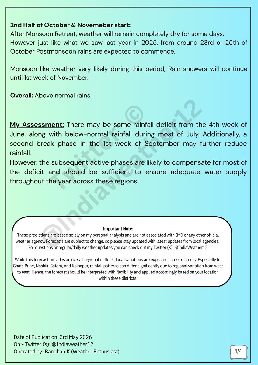
4) Septmeber 2026:
Phase 1 : Monsoon break phase to continue until around 9th–11th of September. The monsoon trough will remain over the foothills of the Himalayas. Sluggish weather with mostly hot & humid conditions is expected.
Scattered/isolated stand-and-deliver thundershowers are expected during this period.
Phase-2 : A strong comeback of Monsoon is possible from around 12th–14th September. A strong system is expected to form in the Bay of Bengal (BoB), which will pull the monsoon trough towards central India.
This event coincides with Ganesh Utsav, so significant rainfall is likely during the festive days.
A very active and wet Monsoon phase is expected. Daily rainfall is likely during this period. 2–3 disruptive, triple-digit heavy rainfall events are possible.
Phase 3: From around 27th–28th September, rainfall will start reducing significantly. Rainfall will shift to convective thundershowers. One day of heavy rain during this period cannot be ruled out.
Overall: Normal or Above normal rains (due to active 2nd phase)
#MumbaiRains #PuneRains #PuneRain #MumbaiRain #MumbaiWeather
🌧️🌴 Monsoon Reaches Keralam; Conditions favourable for Further Advance. 🌴🌧
As indicated, the strengthening cross-equatorial flow has successfully helped Monsoon current to quickly progress northwards.
Today, #Monsoon has officially arrived over #Keralam, around 3 days later than its normal onset date of 1st June. However, the monsoon current has advanced rapidly and today covers the entire state of Keralam along with small parts of South Karnataka.🌧
With supporting UAC (Upper Air Circulation)🌀 present over Bay. Conditions remain favourable for further advancement over Karnataka during the next few days. Thus, monsoon is expected to reach Goa and parts of South Konkan around 7th or 8th of June.
With the advancing monsoon current, gradual increase in thunderstorm ⛈️⚡️ activity and rainfall is expected across Konkan and Western Maharashtra in upcoming days. ⛈️🌧️ Will share further details in next post.
🌧️🌴 MONSOON UPDATE : #Monsoon Finally Set To Resume Its Northward Advance.🌴🌧️
After remaining stalled just south of Kerala for several days, the Southwest Monsoon now appears poised to resume its northward advance.
The delay was primarily due to the absence of any significant Bay of Bengal low-pressure system, combined with a quasi-stationary cyclonic circulation near the Kerala–Lakshadweep region. Additionally, stronger tropical systems over the western Pacific, including Typhoon Jangmi and a disturbance near Vietnam, attracted flow towards them in absence of system over Bay.
🌎🌊 However, the pattern is now evolving.
As these Pacific systems gradually weaken and move northwards, ECMWF and other models indicates strengthening of the cross-equatorial flow over the Indian Ocean and Arabian Sea. This will allow Arabian Sea branch of monsoon to consolidate, with stronger westerlies extending towards the Indian west coast and increasing moisture transport across the region.
📈 An interesting aspect of the current setup is that this strengthening is occurring despite the absence of any major Bay of Bengal system. Instead, the advancing monsoon appears to be drawing support directly from the strengthening cross-equatorial flow and an increasingly organized low-level monsoon jet over the Arabian Sea.
🌧️ Thus, Monsoon onset over #Keralam now looks possible on 3rd or 4th June.
🌴 Following onset, a relatively quick northward progression is possible, covering much of Coastal Karnataka and potentially reaching South Konkan-Goa on around 8–9 June if present trends continue.
🌧️🌊 With moisture transport increasing and the low-level jet strengthening, a widespread Monsoon rains are expected over Coastal Karnataka and Keralam.
We will get more clear dates on Monsoon onset over rest of Konkan including #Mumbai & Western Maharashtra in coming days.
⛈️🌴 #MumbaiRains
A coastal Thunderstorm popup ⛈️ can be seen affecting vasai virar and adj regions.
A typical coastal phenomenon where increased Moisture laden westerlies interacts with land breeze during midnight/early morning hours causing convective clouds ⛈️ or early morning showers starting from coastal areas.
#Mumbai also favourable for showers. ⛈️ Let's see how it goes.
Yesterday, multiple isolated thunderstorms formed over Western Maharashtra as well. Even today isolated thunderstorms are expected to form over Western Maharashtra during afternoon/evening hours. With this we are finally 🙌 into Premonsoon phase as Monsoon starts it Northwards Progression.
🌦️ Weather Forecast for next 3 days (1st June to 3rd June) across Konkan & Western Maharashtra including #MumbaiRains & #PuneRains probability 🌴🌦️
Hot, humid and uncomfortable weather to continue. In fact, this will continue until any meaningful rain happens. Western Maharashtra has started witnessing comparatively cool nights and early mornings due to the westerlies effect 🌬️. While minimums are not ready to drop over Konkan even at night due to high ground level moisture ☁️🌊. A typical pre-monsoon phenomenon. Same conditions to prevail for the next 3 days.
With low-level moisture again increasing, expect isolated light rain showers across the Konkan coast, including #Mumbai and surrounding regions 🌦️. An odd moderate shower at random places is possible too. Some places will miss them completely.
Western Maharashtra has chances of isolated light showers, especially towards the western side near the Ghats ⛰️. Isolated pop-ups might form as well over random places, giving some thundershowers ⛈️. Widespread thunderstorm activity is unlikely.
Meanwhile, the Monsoon is still stuck just below the Kerala coast 🌧️ and is expected to start advancing shiftly towards the north after 48–72 hrs. 🌴