Indians in Taiwan worried by rising racism
A political candidate has promised to ban Indian workers from Taiwan
His campaign poster depicts a man with a turban and the flag of India with a large cross over both
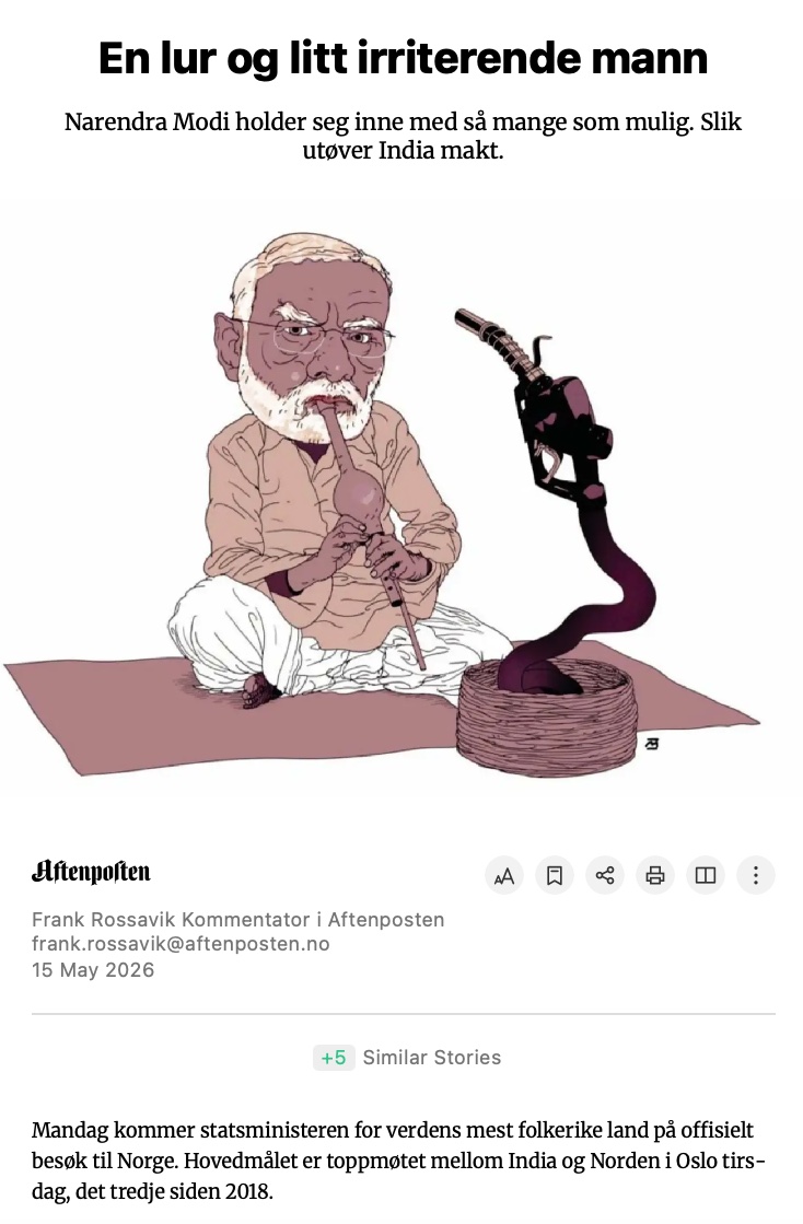
This cartoon, which I assumed wrongly was from some cheap tabloid but was published in Aftenposten, Norway's largest newspaper and "paper of record", isn't a great advertisement of supposedly superior journalistic standards.
Let me explain what just happened today because it deserves so much recognition.
GalaxEye is a Bengaluru startup founded in 2021 by IIT Madras engineers. Today they launched Mission Drishti on a SpaceX Falcon 9. It is India's largest privately built satellite at 190 kg. And it carries a technology that no commercial satellite has ever carried before.
Normal satellites take photos of the Earth using optical cameras. Like your phone camera, but from 500 km up. The problem is obvious. Clouds. Night. Fog. Smoke. If any of these are in the way, the photo is useless. India has monsoon cover for 4 months a year. That is 4 months where optical satellites are partially or fully blind over large parts of the country.
The alternative is SAR. Synthetic Aperture Radar. Instead of taking photos with light, it sends radar waves down and reads what bounces back. Radar goes through clouds, through darkness, through smoke. A SAR satellite can image a flooded village at 2 AM during a cyclone when no optical satellite can see anything.
The problem with SAR is that the images look nothing like photos. They look like grainy black-and-white radar maps. A military analyst or a trained geospatial engineer can read them. A farmer, a disaster response team, or a city planner cannot.
Until today, if you wanted both optical and SAR data for the same location, you needed two different satellites, passing over at different times, at different angles. Then someone had to manually align and fuse the two datasets. Expensive, slow, and the data never perfectly matched because the satellites saw the same spot minutes or hours apart.
GalaxEye put both sensors on one satellite. Optical and SAR, fused into what they call OptoSAR. Three times more information than a single sensor. Processed onboard by an NVIDIA AI chip at 1.8 metre resolution.
Now in practice, during the next cyclone hitting Odisha, one satellite pass gives you a clear image of which villages are flooded, which roads are cut, and which buildings are standing. Day or night. Cloud or clear. In near real-time.
For defence, it means you can monitor a border area 24/7 regardless of weather. For agriculture, it means tracking crop health across an entire monsoon season without a single cloud gap. For infrastructure, it means monitoring construction progress on highways and bridges without waiting for a clear day.
GalaxEye tested their SAR tech on ISRO's POEM orbital platform. The satellite was tested at ISRO facilities. IN-SPACe provided regulatory clearance. NSIL, ISRO's commercial arm, will distribute the imagery globally. And it launched on SpaceX because ISRO's PSLV doesn't have the right orbit slot for this mission.
Yes, four IIT Madras graduates built a world-first satellite in 4 years in Bengaluru.
Take a bow!
WATCH: Taiwanese grandmothers aged 89 and 91 train at the gym. An increasing number of elderly people in Taiwan’s super-aged society are hitting the gym to stay healthy, both physically and mentally.
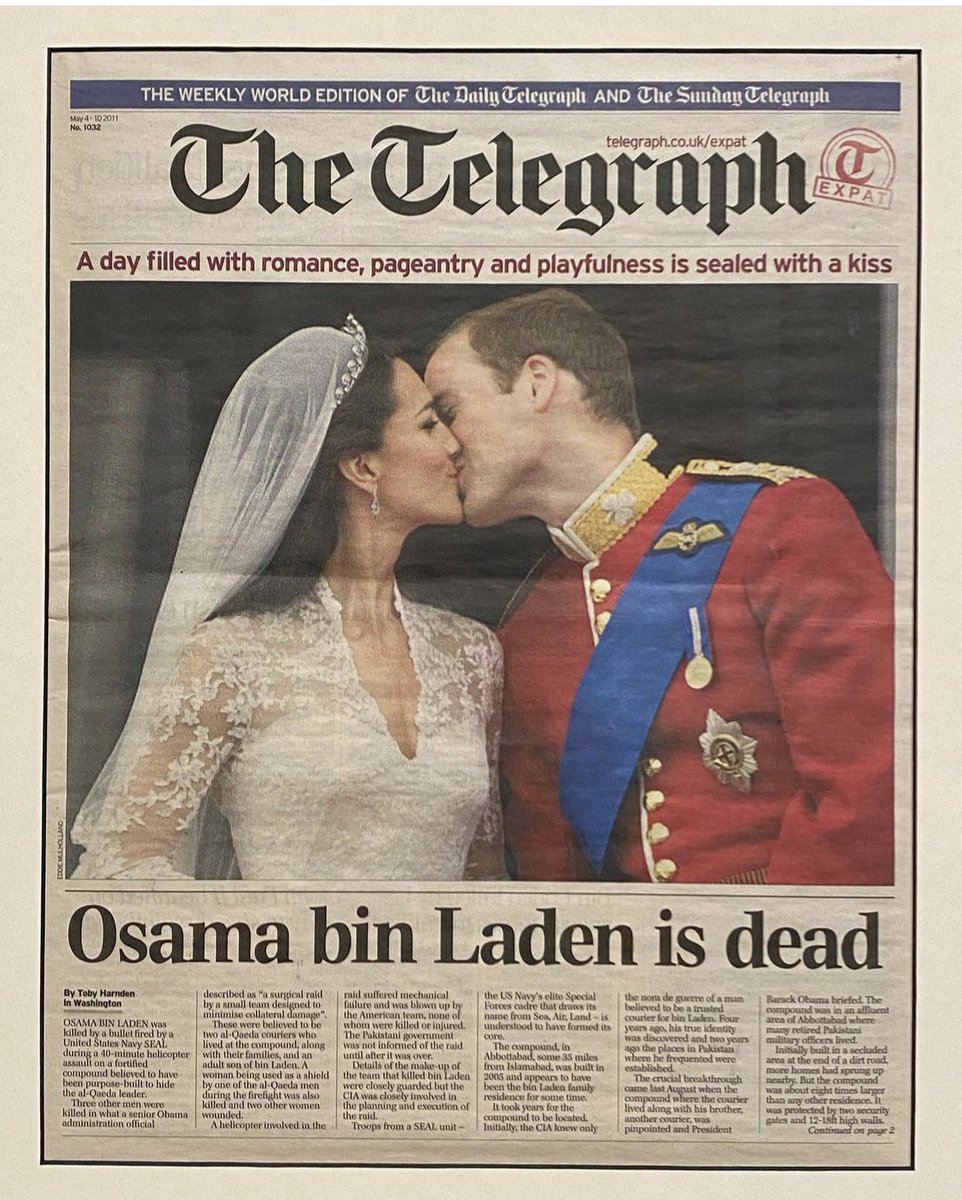
15 years since I was asked by @Telegraph to write a photo caption for a royal kiss and decided to go with something completely different that happened that day
#WATCH | PM @narendramodi and US President Donald Trump held a key phone call, discussing India–US ties and the evolving situation in West Asia.
US Ambassador Sergio Gor said the talks included major strategic updates, with “big-ticket announcements” expected soon. The Ministerial Quad meeting is also likely during Marco Rubio’s upcoming India visit.
@PMOIndia@StateDept@USAmbIndia@JessicaTaneja
#IndiaUSRelations #ModiTrump #WestAsia #Quad #Diplomacy #GlobalPolitics
Hungary under Orbán was not a classic fascist or monarchical regime. It was a species of what political scientists call "competitive authoritarianism" — where elections are generally free, meaning not formally rigged, but held under extremely unfair conditions.
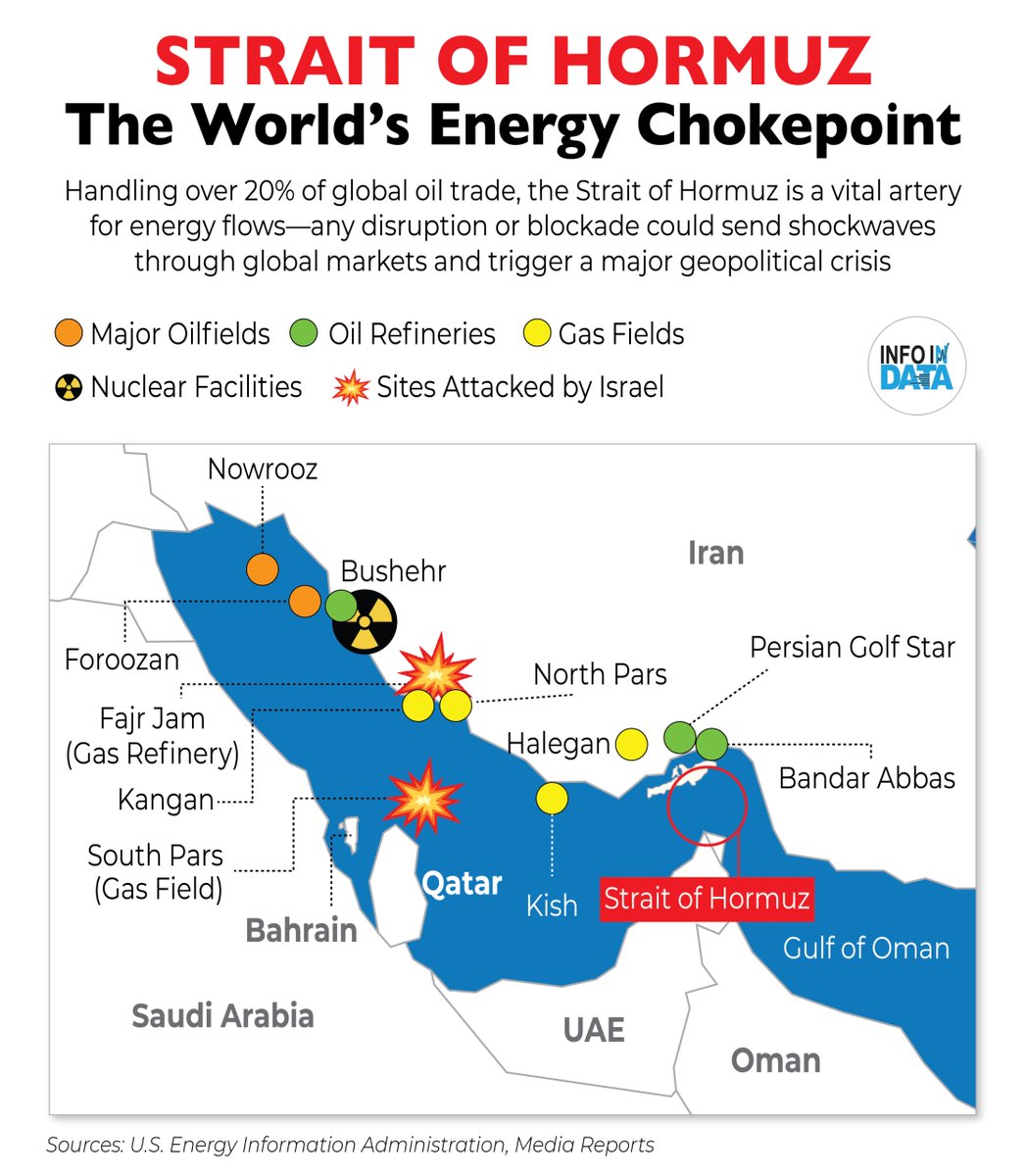
VIDEO EXPLAINER: The most important map of the Third Gulf War — the oilfields, the Strait of Hormuz, and the bypass pipelines.
Plus a look at how, two weeks into the war, Iran is still exporting lots of its oil, and most of it, via the strait.
@opinion
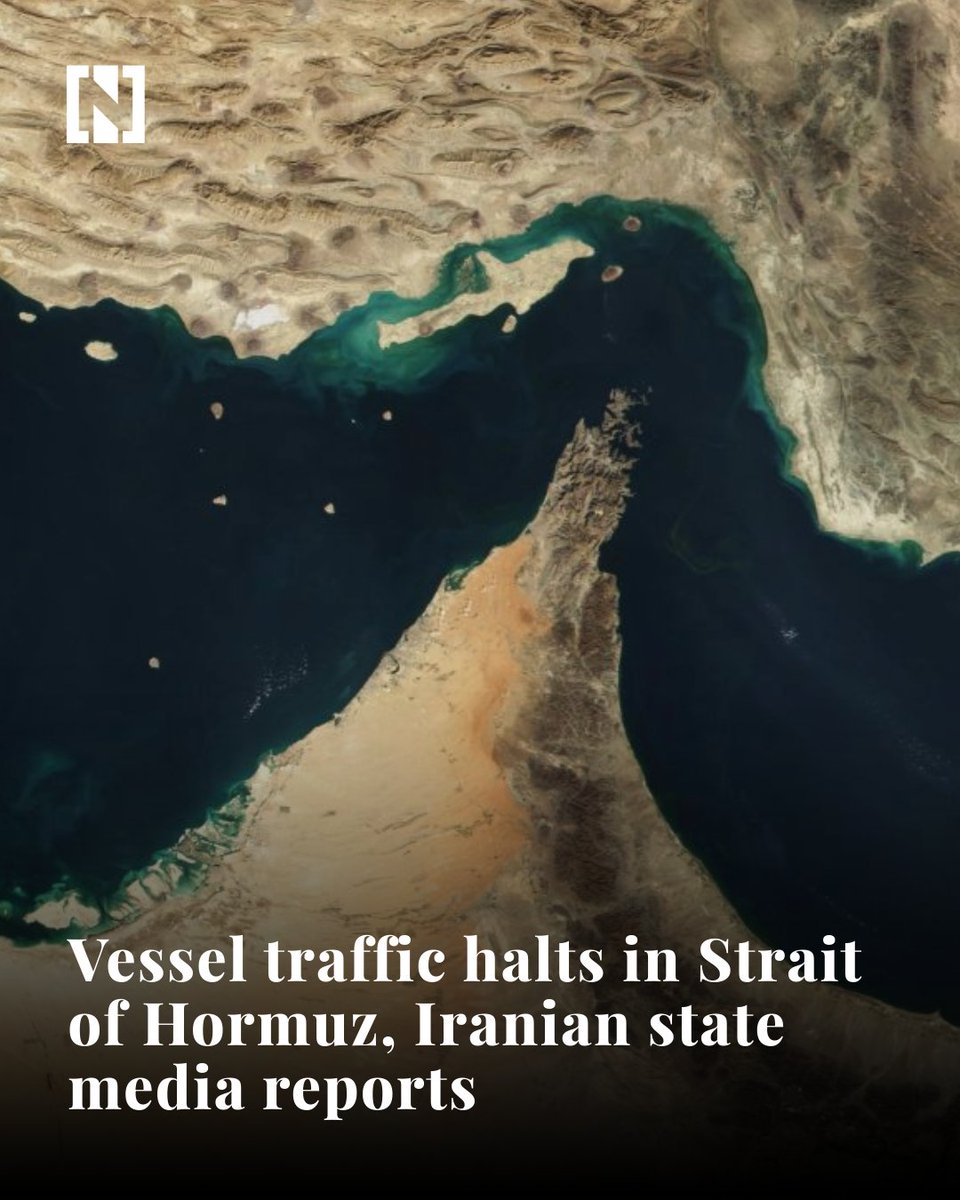
Shipping traffic around the Strait of Hormuz has halted, Iranian state media reported, sharing images that appeared to show dozens of ships stationary in and around the waterway. The National confirmed independently that ships had been told not to enter the Strait. Iran sits on the northern shore and controls key approaches to the channel, through which a significant share of global oil shipments pass.
Some vessels have been instructed not to proceed through the Strait, a regional shipping executive said. ‘Some ships have been advised on VHF by Iranian Navy to hold position and avoid transiting the Strait of Hormuz at this time,’ said Farhad Patel, director of Dubai-based Sharaf Shipping Agency. ‘We are closely monitoring the situation in coordination with relevant maritime authorities and awaiting further clarification before normal transit resumes,’ he added. There have been no reports of damage to vessels or crews under his agency. ‘
Safety remains the top priority, and operators are proceeding with heightened caution,’ Mr Patel said. He added that any prolonged restriction could affect tanker scheduling, freight rates and insurance exposure, although it is too early to assess the full commercial impact.
US–Israel strikes on Iran put the Strait of Hormuz at the center of global risk. Just 21 miles wide, it carries ~21 mb/d of oil, 20–25% of global seaborne trade, and a third of LNG. Many nations depend on it, and any further escalation could send fuel prices soaring worldwide.
The American bases that were attacked today by Iran:
Bahrain:
• Al-Juffair Base
• U.S. Fifth Fleet Command Center
Qatar:
• Al-Udeid Air Base
Kuwait:
• Arifjan Camp
• Ahmad Al-Jaber Air Base
• Mubarak Air Base
United Arab Emirates:
• Al-Dhafra Air Base
• Jebel Ali Port
• Fujairah Air Base
Saudi Arabia:
• Prince Sultan Air Base in Riyadh
• Tabuk Base
• Khamis Mushait Base
• A western base in Jeddah
Jordan:
• Muwaffaq Salti Air Base
Iraq:
• U.S. base in Erbil
Britain’s Dy prime minister @DavidLammy : “I know former prime minister Rishi Sunak is not just a great son of the United Kingdom, he’s also a great son of India (@RishiSunak : ‘Son-in-law!’). my great grand mother (my mothers side) was from Calcutta (Kolkatta).
"The 20th century was the American century. The first half of the 21st century will still be American. But I believe they will have to share the second half of the century with China and India," said former Singapore PM Lee Kuan Yew in 2009