Just your average run of the mill weather junkie. I get to talk weather on WITN News at sunrise where I've been doing the morning weather for 20+ years.
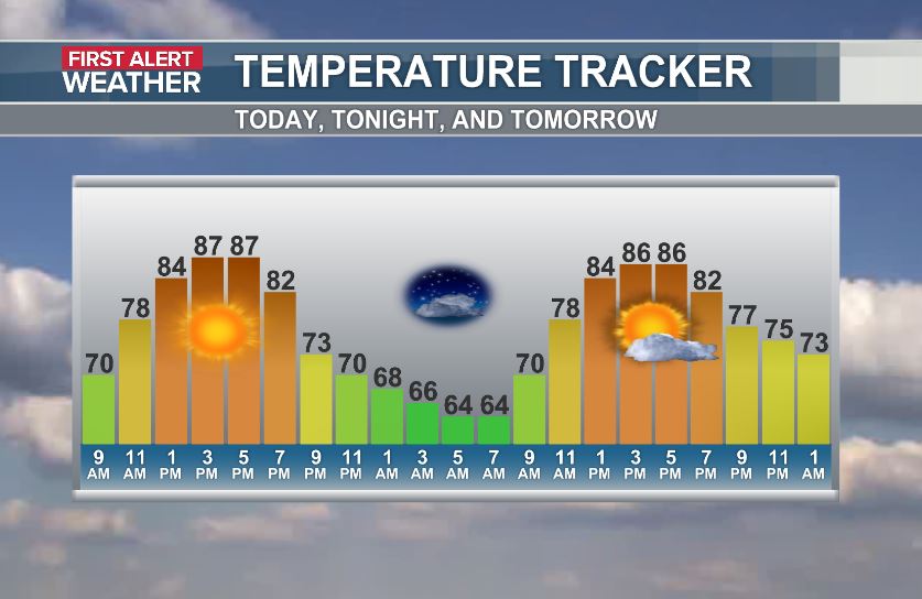
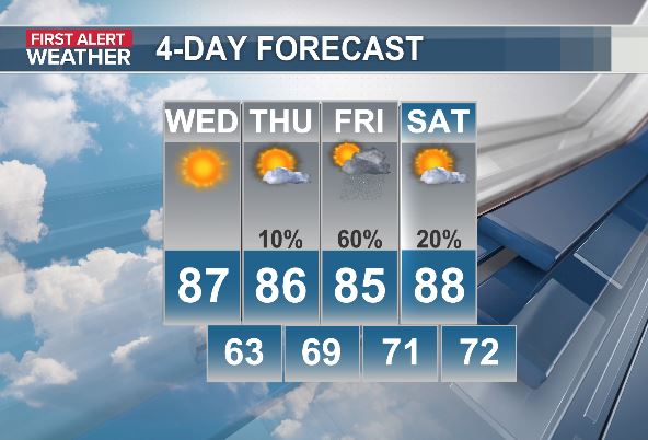
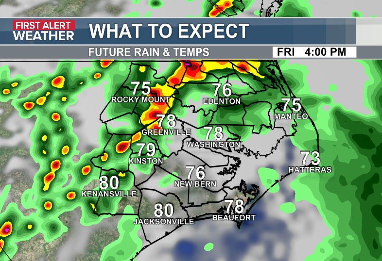
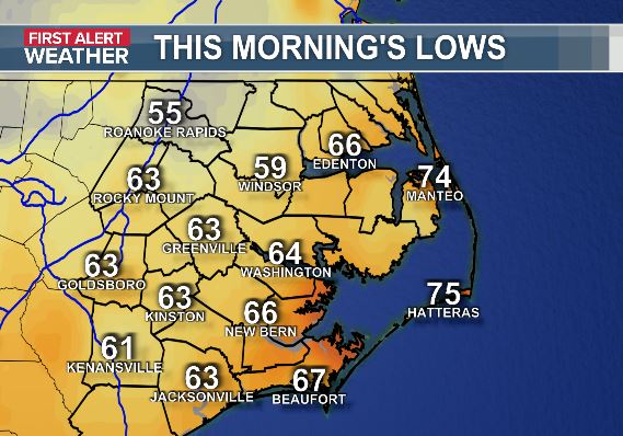
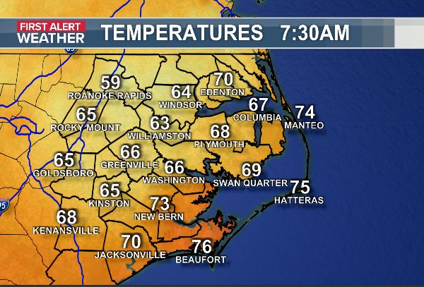
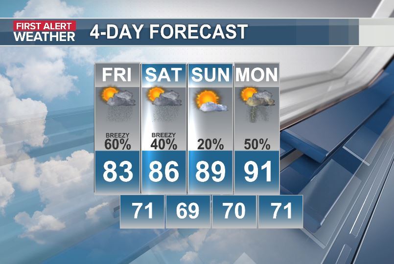
Feeling good in the neighborhood! The mercury started off in the mid 60s back at sunrise. I think we'll peak around 87, low humidity degrees this afternoon under sun filled skies. Look for the same kinda day tomorrow before rain arrives on Friday.
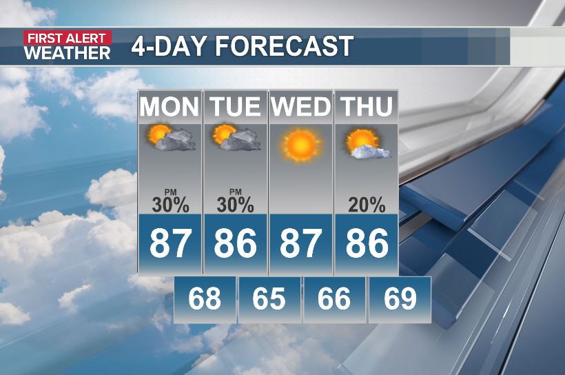
Good news on the weather front folks...Not as hot this week. Highs this week will likely stay in the 80s for most areas with overnights dipping into the 60s each night. Lows along the coast will stay in the 70s. Rain chances will generally run 30% or less each afternoon.
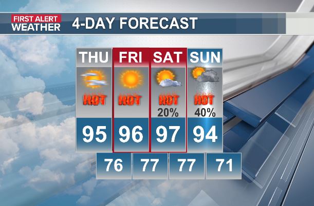
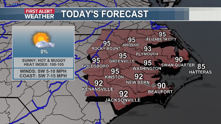
We'll be stuck in the oven the next 4 days folks. Highs each afternoon will reach the mid 90s inland to 90° on the coast. The heat index will run from 102°-107°. The hottest days will be Friday and Saturday. Both days will be First Alert Weather Days. Stay hydrated out there!
Hot, hot, hot folks. The mercury will click upward a bit each day through the end of the week. Low 90s today will lift to the mid 90s by late week under mostly sunny skies. The heat index will run 100°-106°. Rain chances will stay at or below 20%. Stay hydrated out there!
Showers and thunderstorms are shifting to the Outer Banks this morning. The rain will move off the coast by late morning with a quiet afternoon to follow. Rain chances will trend downward, while the heat trends upward this week. The heat index will likely be near 100° by mid week
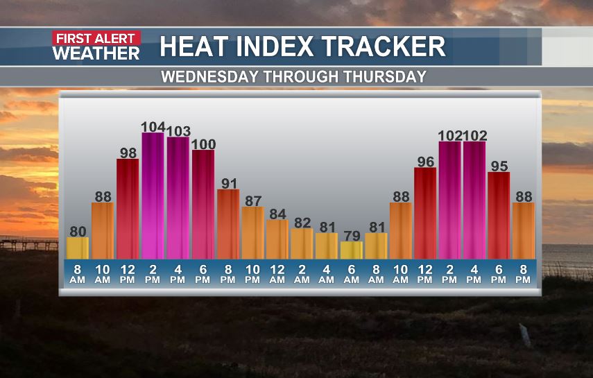
The heat will stick around through tomorrow, but we'll see fewer storms. Low 90s today will push the mid 90s Friday. The heat index will peak near 100° today to around 103° Friday afternoon. Rain chances will run around 20% both days. We'll see a little dip in temps this weekend.
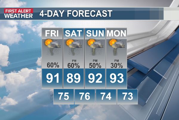
Heavy downpours along the I-95 corridor will continue to move slowly southward through midday. Isolated flooding will be possible for a few locations. Temps will climb to 90° with the heat index near 100°. We'll stay hot and muggy through the weekend with more scattered storms.
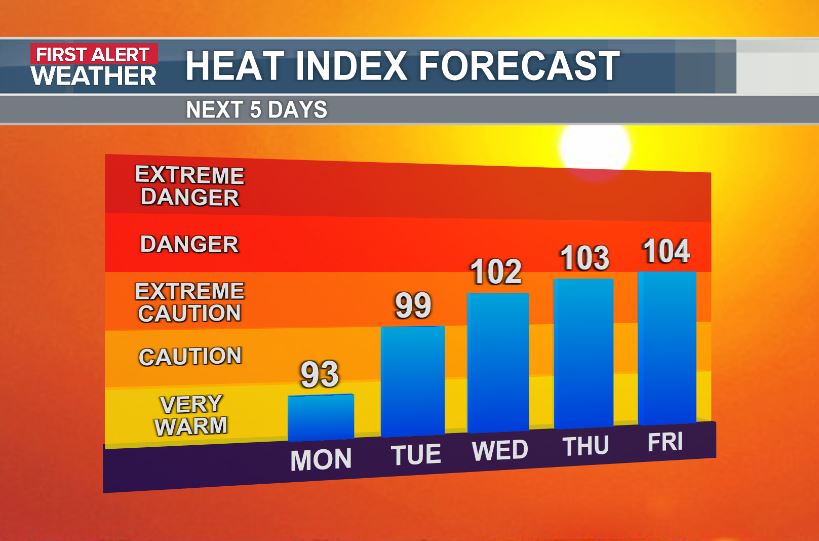
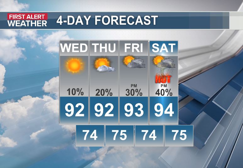
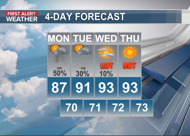
The heat and humidity will slowly climb over the next several days with mid 90s by the weekend and heat index values pushing to near 105°. Rain chances will slowly climb as well with a slim 10% today, climbing to 40% each afternoon over the weekend.
Temps will be climbing a bit each day for the next several days folks. Highs near 90 today will reach the mid 90s by Friday. Humidity levels will be slowly climbing as well with the heat index exceeding 100 by Friday. Rain chances will stay at 30% or less through late week.
Carpe diem. Actually, seize the next 2 days folks..the mercury is headed back upward later this week. Highs this afternoon will peak in the mid 80s with a few showers popping up, but nothing like yesterday's storms. The heat and the humidity will build back in by late week.
No heat advisory today! That's your good news of the day. Highs will crest near 90° this afternoon with the heat index peaking near 102°. We'll likely see a good coverage of showers and storms from mid afternoon through sunset, but severe storms are unlikely. Similar stuff tomo.
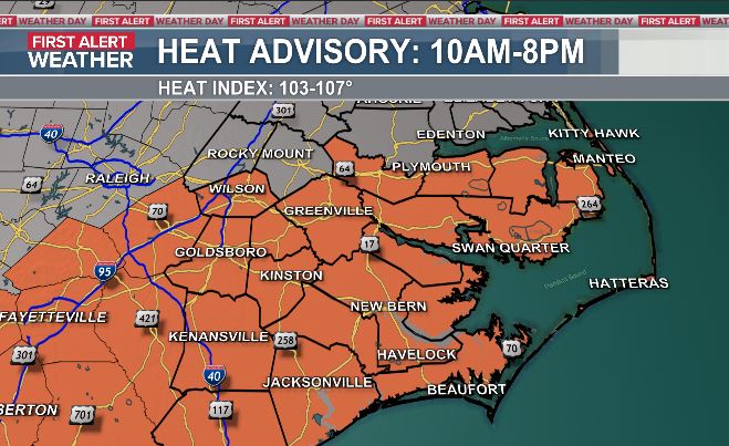
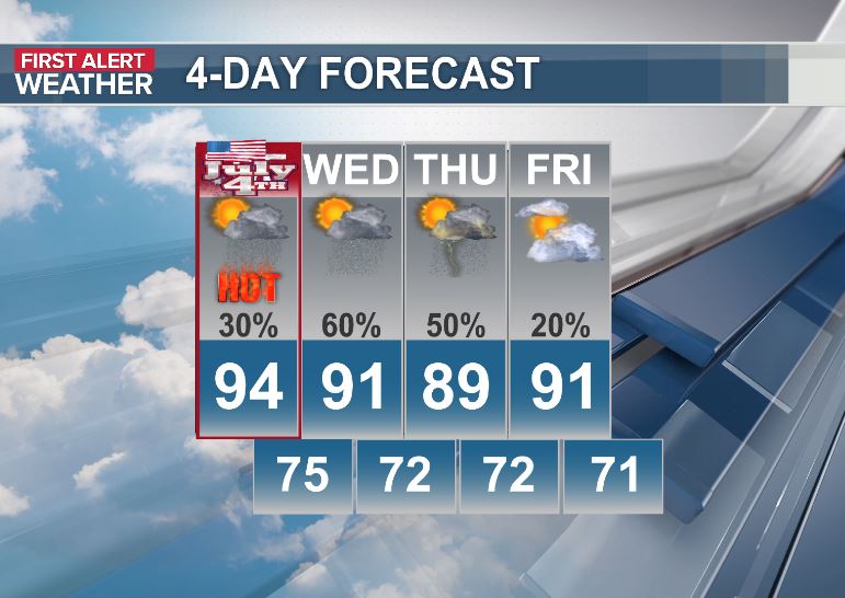
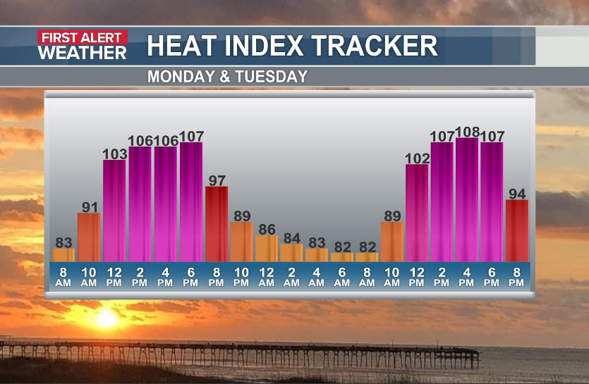
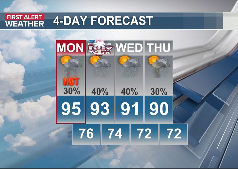
We'll be roasting hot dogs in a roasting airmass this afternoon folks. Highs will again reach the mid 90s with the heat index nearing 107° this afternoon. A Heat Advisory will be in effect from 10am-8pm. A few evening storms should dissipate for most areas by fireworks time.
More intense heat today folks. It will feel like 105°+ this afternoon. Stay well hydrated out there. We'll be watching the radar as well today. Isolated severe storms will be possible from 4pm to 10pm. Wind gusts to 60 will be the primary risk if you do catch a storm.
Here comes the heat folks. Highs will peak in the low 90s today & tomorrow with a jump to the mid 90s Sunday & Monday. The heat index will push the upper 90s through Saturday with climbing humidity levels making it feel close to 105° by Sunday & Monday. Rain chances stay low.
Less smoke today folks. As the smoke thins out the next few days the heat will build in. Highs will climb a few clicks each day with upper 80s this afternoon lifting to the mid 90s by Sunday. The humidity will climb as well, yielding heat index values nearing 105° by Sunday.
First Alert Weather Day folks. The risk for severe thunderstorms will come from 6pm this evening through 2am Tuesday, starting well inland and headed coastward after midnight. Heat index values will near 100° this afternoon helping to fuel the potentially strong storms tonight.
We'll be dealing with more showers and and storms today, but I don't expect the storms to be quite as strong as yesterday's. If you catch a storm today, expect some very heavy rain and frequent lightning with wind gusts to 40 mph. Rain chances trend downward this weekend.
First Alert Weather day today folks. We're not expecting any severe weather, but a few locally heavy downpours may bring isolated flooding to a few spots. Rain totals should average around 1.00" for most areas today with more to come tomorrow and Friday. Today's high around 80°.
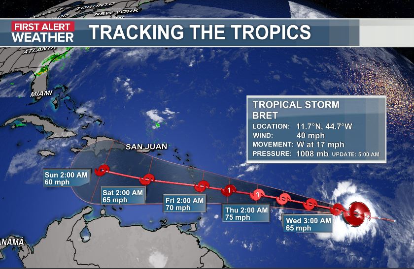
In and out of rain the rest of the week folks. Scattered showers with heavy downpours will likely bring 2-4" of rainfall over the next 3 days. Tuesday night and Wednesday will be First Alert Weather days with the risk of isolated flooding. Bret is headed towards the Caribbean.
No Air Quality Alert today folks. We'll still have a little smoky haze, but it won't be as thick as the last couple days. The thermometer will climb from the mid 50s this morning to 80s this afternoon. Plenty of sunshine on tap this weekend with climbing temps each day.