Big shout out to former @Sihi_Lab postdoc @ZhuonanWang and co-authors @JituOr @sr_weino @KatheMathBio and Umakant Mishra! Our SOC estimates outperformed commonly used gridded soil products.https://t.co/6A6NYmMPvh
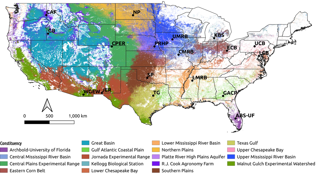
This new paper quantifies how well working lands are represented by LTAR sites, and explores strategies to leverage complementary sites from @NEON_sci and @USLTER
ARS researchers are looking to ensure that working lands in all U.S. regions are represented within the USDA Long-Term Agroecosystem Research (LTAR) Network. https://t.co/1orhY8b6me
#USLTAR
We are seeking a Geospatial Modeler technician to apply #MachineLearning to #RemoteSensing data. Come join our awesome team in the @ComputationalS Group at @ORNL! https://t.co/PSueqbSJ3c
We @ORNLBio_Env are looking for a Postdoc with interest and expertise in Machine Learning and Remote Sensing to lead the work on development of ML algorithms and scalable geospatial analytics methods to study vegetation in natural and managed ecosystems.
https://t.co/hl4v95RLLY
@BharatSharma_IN's paper on carbon cycle extremes from long-term global Earth system model simulations is out in #JGRBiogeosciences. He attributes changes in those extremes to climate drivers that change over time @ORNL@ORNLComputing @ComputationalS @ORNLBio_Env
Paper just out on analysis of carbon cycle extremes from long term (1850-2300) Earth System Model simulation, led by PhD candidate @BharatSharma_IN, from his research at @ORNLBio_Env@ORNLComputing
Our Paper is out in @JGRBiogeo, quantifying the impact of CO2 and land use & land cover change (LULCC) on GPP extremes and their attribution to compound climate drivers. https://t.co/4j4gT7PEDm. We used CESM1BGC simulations, forced with RCP8.5+ECP8.5 and with and without LULCC.
@aJollyAdventure I used their Python API and it worked reasonably well for small regions. I had to do few variables and year at a time since it crashed if asked for too much. Did all processing after downloading locally.
Come join our awesome team! We are seeking a Computational Scientist or Engineer to perform #DevOps engineering for the next generation #Earth science data system. https://t.co/oIox2JTIQs @ORNL @ComputationalS
Come join our awesome team! We are seeking a Computational Scientist or Engineer to perform data discovery and user interface software engineering for the next generation #Earth science data system. https://t.co/R26AA1cVGJ @ORNL @ComputationalS
We are seeking a Research Scientist in Computational Ecohydrology to develop and apply mathematical theory, models, and #AI/#ML methods to the investigation and simulation of plant #carbon and #water interactions https://t.co/O2Vr9bqcsp @ORNL @ComputationalS
@jawzsh@BenjaminSulman@Colleen_Iversen @vgsalmon @AmyAkillk@ORNL We have done it with AVIRIS-NG around NGEE study Watersheds (manuscript in near final draft stage), currently extending it to broader Seward with S-2.
@Kate_J_Fuller@GEDI_Knights@Web_LiDAR As per ATBD Section 5.2.2, rh metrics are relative to elev_lowestmode, and rh0 is often times a negative value. Can @GEDI_Knights help clarify where the ground is (elev_lowestmode) vs rh0?
@Kate_J_Fuller@GEDI_Knights@Web_LiDAR Not sure, still trying to understand the documentation. Fig 8 of https://t.co/XSvJ7RoiTh, and Fig. 3 of https://t.co/Qr82NMNB0q don't show ground elevation and rh0 as same.
Ever wonder where the flux source areas (#footprint) of eddy-covariance towers are? esp, when using large datasets like #FLUXNET@AmeriFlux. Check our new synthesis collaborated by many AmeriFlux teams & ~214 sites
https://t.co/fdGs0g6tDP