September is National Preparedness Month, & this year's theme is Americans Stand Ready. Follow @Readygov to learn how you can protect yourself & your family in emergencies, & how we all have a role to play in making our nation resilient.
More in our blog: https://t.co/HA3iwZQdo8
Showers and thunderstorms are expected today. Flash flooding will be possible, especially given the saturated ground. Thunderstorms will remain possible the next several days, but drier weather will return early next week.
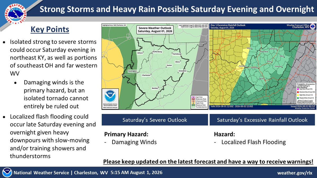
Strong to severe storms are possible later this evening across the far west, then across much of the forecast area Sunday afternoon/evening. In addition, localized flash flooding will remain possible late this evening through Sunday. Please keep updated on the latest forecast!
A tornado can happen suddenly! Be ready: know how to get to a safe place as soon as you get a tornado warning. Interior rooms without windows and on the lowest floor of the building are your safest option. https://t.co/NLHlwi7XD5
⛈️ Severe storms & heavy rain possible late Monday into Tuesday. Damaging winds and locally heavy rain are the primary threats. With an overnight threat for severe weather Monday night make sure to have alerts on!
➕ ➖ The biggest threat to the volunteer fire service isn’t recruitment, it's math.
Mark Lambert says staffing numbers, response times and availability are the new variables in volunteer firefighter recruitment and retention?
👉 Read more: https://t.co/wV4OpxYVg4
The Flood Watch for Flash Flooding remains in effect until 11 PM EDT tonight for areas along and south of the I-64 corridor, including the mountains. Heavy showers and storms are forecast once again today into tonight. #kywx#ohwx#vawx#wvwx
Flash flooding will be very likely each afternoon today through Saturday. Scattered to numerous showers and thunderstorms are expected each day with rounds of heavy rainfall and training showers/storms leading to flash flooding.
There is a chance of showers and thunderstorms this afternoon and evening. Damaging winds are possible with some thunderstorms. Localized flash flooding is also a possibility. #wvwx#ohwx#kywx#vawx
Be sure to follow these heat safety tips if you're going to be outdoors:
-Drink plenty of water
-Identify shaded or covered areas
-Head out of the sun and take a break at the first signs of heat-related illness
NWS has issued a flood watch in effect from 8 am this morning through this evening.
Excessive runoff may result in flooding of rivers, creeks, streams, and other low-lying and flood-prone locations.
Scattered strong to severe thunderstorms will be possible on Thursday with peak heating. Heat index values could reach the upper 90s to around 100 degrees across the lowlands in the afternoon given oppressive humidity.
The spring fire season ends today. Daylight burning is permitted, but the risk remains. Keep a 10-foot safety strip perimeter clear. Keep water nearby. Stay safe. 🌅✔️
Rounds of showers and storms are expected today. Some storms later today could be strong to severe, with damaging winds and heavy downpours being the primary hazards, while some hail is also possible. Heavy rain could result in flash flooding. Remember - Turn Around, Don't Drown!
🔥 We are experiencing low humidity and dry forest conditions. Follow all state laws to protect your community. Only burn between 5:00 p.m. and 7:00 a.m. If conditions are windy, do not burn. Prevention starts with you.
Learn More: https://t.co/MiBYIn1OCt
Possible severe weather today and tomorrow. Wednesday should be much more active with more thunderstorms, some of which could become scattered strong to severe. Check out the graphic for more details. Also, check out you local forecast at https://t.co/ZkcccJeOrn.