Heaviest rain in the metro right now is right over Grimes, slowly lifting to the east and northeast toward Polk City and Ankeny over the next 30 minutes. Nothing really severe with any of this, just occasional torrential downpours and some lightning!
A broken line of storms is developing from southwest Iowa through Atlantic and Fort Dodge. These slow moving storms are producing very heavy rainfall on the order of 1 to 2 inches. This line will slowly sag into central Iowa as we move into the evening hours.
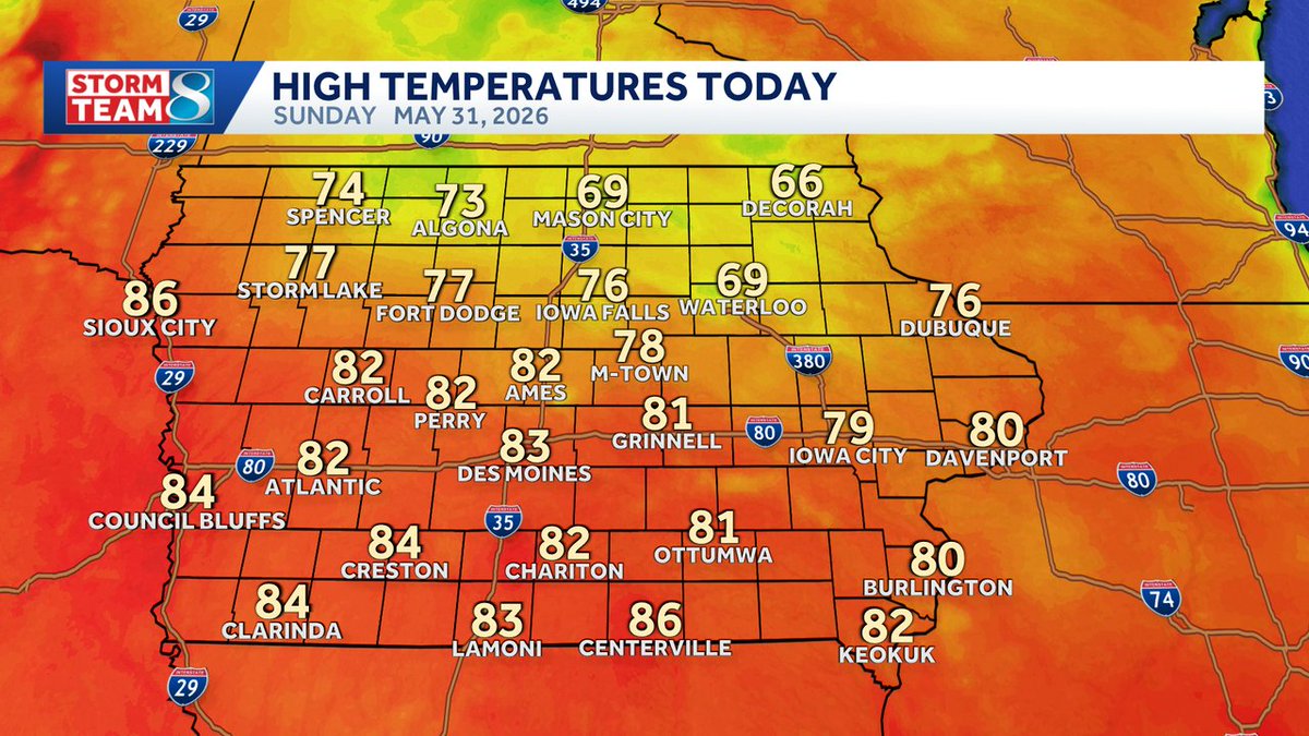
Warm and humid this afternoon with temperatures pushing into the low 80s. Storms will be minimal through the early afternoon hours, but will be increasing in coverage by the drive home. Pockets of heavy rainfall are likely as storms develop late today.
Flood Watch for portions of central and southwest Iowa this evening through Friday morning. Pockets of heavy rain are expected to develop as we head into the evening hours, with a few areas potentially seeing up to 4" of rainfall which could result in localized minor flooding.
A very nice evening here across central Iowa! A touch breezy at times, but otherwise pretty comfortable with temperatures in the 80s falling into the 70s. Humidity levels remain very low helping to make it feel so nice. Humidity levels and rain chances increase for the day ahead!
A Severe T-Storm Warning has been issued for Dallas, Guthrie, Greene, Boone until Jun 01 6:15PM. Strong winds or large hail is possible, seek shelter indoors until the storm has passed! Stay with KCCI for the latest updates. #iawx
A Severe T-Storm Warning has been issued for Emmet, Kossuth until Jun 01 11:30AM. Strong winds or large hail is possible, seek shelter indoors until the storm has passed! Stay with KCCI for the latest updates. #iawx
A Severe Thunderstorm Watch has been issued for portions of Iowa until Jun 01 3:00AM. Severe storms with damaging winds or hail are expected to develop. Stay alert to weather conditions and watch for updates and possible warnings! #iawx
Scattered thunderstorms continue to push their way out of central Iowa this morning! While there may still be a few showers around by 10am, generally dry conditions will return this afternoon with at least a little sunshine. Temperatures warm into to the upper 70s to around 80°!
Heavy downpour just rolled into Newton! Nothing severe with this, just a little thunder and the downpour. Storms should slowly exit central Iowa by 10am, with a little more sunshine on the way this afternoon.