⚠️Weather Warn Wednesday/Thursday - Heat
⚠️Heat Advisory El Paso - Wednesday Noon Through 9 PM
Your Wednesday will be partly cloudy and hot. We will see a high El Paso around 105°. West wind 5 to 15+ mph.
Track our weather: https://t.co/RvhxIvUB6M
⚠️Weather Warn Wednesday/Thursday - Heat
⚠️Heat Advisory El Paso - Wednesday Noon Through 9 PM
Remember to stay hydrated and cool, especially during the afternoon/evening hours
Track our weather: https://t.co/RvhxIvUB6M
⚠️Weather Warn Wednesday/Thursday - Heat
Temperatures still very warm (80s to lower 90s), as we go into the night. Temperatures will drop back into the 70s, making for a milder start to our Tuesday morning.
Track our weather: https://t.co/RvhxIvUB6M
⚠️Weather Warn Wednesday/Thursday - Heat
Higher pressure returning to the Borderland will drive our temperatures up. This will mean highs of 104° to 106° possible Wednesday/Thursday
Your Tuesday🌥. High El Paso around 103°. S 5-10 mph
Track our weather: https://t.co/e4nA2Ni0y4
Dry and hot tomorrow, when triple digits are more likely. The forecast high tomorrow is around 103° 🌡
West southwest winds of 5-10+ mph 🌥
Stay weather aware and be prepared for these hotter temperatures.
Track our weather: https://t.co/RvhxIvUB6M
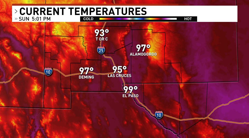
Unofficial high today in El Paso of 99° 🔥
Almost scraping those triple digits. Chances for hitting triple digits rise next week. Hottest days will likely be between Tuesday and Thursday. A heat advisory could be issued next week.
Track our weather: https://t.co/RvhxIvUB6M
Tomorrow could possibly be the first triple digit day of the year. El Paso is forecasted at 101°
The first triple digit day last year was May 22nd at 101°🔥
Westerly flow tomorrow with WSW of 5-15+ mph 🌤
Track our weather: https://t.co/RvhxIvUB6M
Temperatures are rising compared to yesterday. Friday's high was 82°, today we have observed a high so far of 92° in El Paso.
Temps will possibly rise into triple digits by tomorrow and are more likely for the start of next week 🔥
Track our weather: https://t.co/RvhxIvUB6M
*Hotter🌡 Temperatures Return/First Triple Digits Likely
As higher pressure returns, temperatures will also begin to heat up in the drier air.
Your Saturday will be partly cloudy🌥. High El Paso around 95°. Southwest wind 5 to 10+ mph
Track our weather: https://t.co/RvhxIvUB6M
*Blowing Dust Advisory West El Paso/Las Cruces - until 9 p.m..
A look at some of the dust starting to move into El Paso(especially affecting West El Paso)
Track our weather: https://t.co/RvhxIvUB6M
With moisture still in the area, we will see a slight chance for storms(20%) again for our Friday.
Your Friday will be partly cloudy with a 20% chance of thunderstorms. We will see a high El Paso around 89°. Southeast wind 5 to 15+ mph
Track our weather: https://t.co/RvhxIvUB6M
A look at current temperatures in the 70s and 80s, making for a mild/muggy afternoon(after last night's rain). We will see temperatures drop back into the 70s most areas around sunset. With a 20% chance of a shower or storm
Track our weather: https://t.co/RvhxIvUB6M
Flood Advisory - West El Paso
West El Paso and The Upper Valley until 2 a.m.. Up to .75 inches of rain has fallen. Avoid low-lying and poor drainage areas.
Track our weather: https://t.co/RvhxIvUB6M
⚠Flash Flood Warning - Las Cruces
Including Mesilla until 10:15 pm. Up to 1.5 inches of rain has fallen. Flash flooding is ongoing or expected. Turn around, don't drown.
Track our weather: https://t.co/RvhxIvUB6M
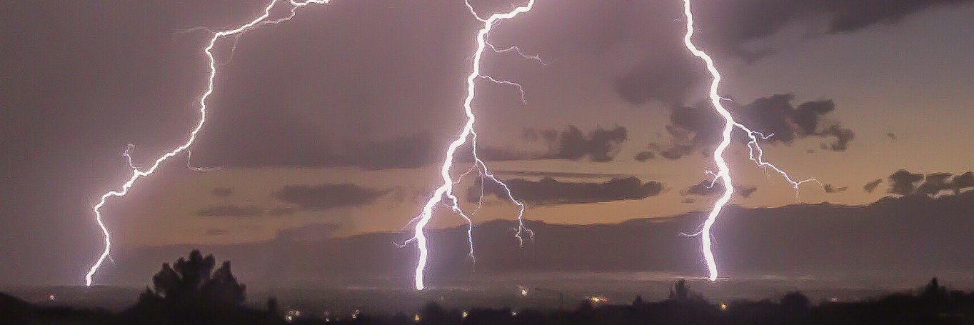
⚠Severe Thunderstorm Warning
Until 8:15 p.m. Storm located near Las Cruces/Mesquite, moving north at 10 mph. Hazard 60 Mph Wind Gusts And Quarter Size Hail.
Track our weather: https://t.co/RvhxIvUB6M
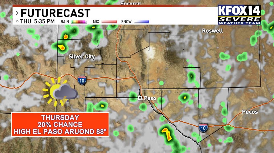
With plenty of moisture remaining in the area, we will see continued chances for showers/storms through Friday.
Your Thursday will be partly cloudy with a 20% chance of thunderstorms. We will see a high El Paso around 88°. SE 5-10+ mph
Track our weather: https://t.co/RvhxIvUB6M
Severe Thunderstorm Warning - (Far)Northeast El Paso
Until 8 p.m.
Flash Flood Warning - Northeast El Paso
Until 9:15 p.m.
Track our weather: https://t.co/RvhxIvUB6M