2(2)
⚡⚠️However temperatures is expected drop again from 1 July as monsoonal moisture reaches Kashmir. As this moisture interacts with the valley's mountainous terrain it is likely to trigger widespread spells of rain and thunderstorms across the Kashmir Valley.
🔴Temperatures across the Kashmir Valley are expected to rise by 3–4°C temporarily over the next three days, with the highest temperatures likely on 29–30 June. Maximum temperatures are expected to range between 33°C and 35°C across most parts of the valley.
1(2)
@aamir471711 A gradual rise in temperatures is expected over the next few days. However conditions are not expected to reach heatwave criteria. Maximum temperatures will generally hover around 30°C with some days recording slightly higher values.
Monsoon Outlook
⚠️⚡Current global model guidance (GFS/ECMWF) indicates a favorable environment for further advancement of the Southwest Monsoon during the last week of June and the first week of July. Strong low level southwesterlies over the Arabian Sea along with
#moonsoon
country possible by the first week of July if prevailing conditions persist.
◾️For Jammu & Kashmir, monsoonal moisture is expected to gradually increase towards early July.
a well-established monsoon circulation, are expected to support the northward progression of monsoon currents.
As a result, the Southwest Monsoon is likely to advance into the remaining parts of North and Northwest India during this period, with near-complete coverage of the
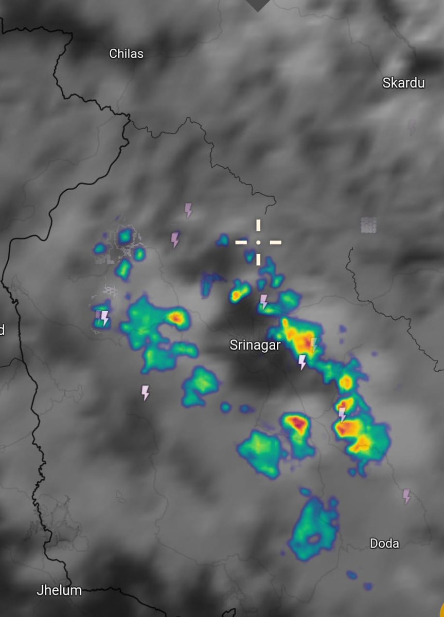
⚠️⚡As expected, convective cloud formations have developed over scattered parts of the Valley. Intense thunderstorm activity is being reported from some areas.
support, but sudden storms develop unexpectedly.
Overall, weather prediction remains challenging at present due to the Valley's highly dynamic atmosphere and terrain complexity and rapid variations in local weather conditions this occurs mostly in summers here.
These probabilities have been mentioned due to the highly variable atmospheric conditions prevailing over the Valley these days.
At times, weather models indicate all the necessary dynamics for a good spell, yet little or no activity occurs. On other occasions, models show weak
Weather Update
⚡As we are aware, convective cloud formations have remained active in the valley during the past 3–4 days, bringing spells of rain, thunderstorms, and locally intense weather activities. According to the models, the wind convergence zone is expected to remain
active over the region during the coming days as well, favouring continued cloud development and intermittent rain/thunderstorm activity on and off.
🔴Apart from this, a fresh Western Disturbance (WD) is expected to affect the region around 18 June, which may further enhance