KWT COMES TO YOU. HELP US TAKE THE NEXT BIG STEP!
For years, we've brought Cornwall's weather to your screens. Now we want to bring KWT into your schools, communities and local events!
We're raising £20,000 to create a mobile weather education setup, complete with forecasting equipment, interactive displays, educational resources and everything needed to make learning about the weather fun for all ages!
And we don't need to reach £20,000 to get started. Every donation helps us build the project piece by piece.
Imagine if just a small percentage of our amazing followers donated £1!
Can't donate? A simple share helps enormously too.
Support our Crowdfunder:
https://t.co/tjawwgpNex
Together, we can take KWT from the screen and into the heart of Cornwall!
From Moor to Shore, there is only one of us for all of you!
Thank you from everyone at KWT!
KWT weather watch for Cornwall: Monday's rain and strong winds!
Well, here we go again! Just when we were getting used to a few days of relatively dry, settled but rather chilly weather, it looks as though the Atlantic Ocean has decided we've had enough peace!
Yes, Kernow Weather Team is issuing a weather watch for Monday, as an approaching area of low pressure has the potential to bring a spell of wet and increasingly windy weather across Cornwall and the Isles of Scilly.
After those frosty mornings, lovely sunny spells and temperatures dropping below freezing in some locations, we're now preparing for a change to something considerably milder, wetter and windier.
Mother Nature clearly can't decide whether she wants autumn or winter, so she's decided to give us a bit of everything!
Monday, here comes the rain!
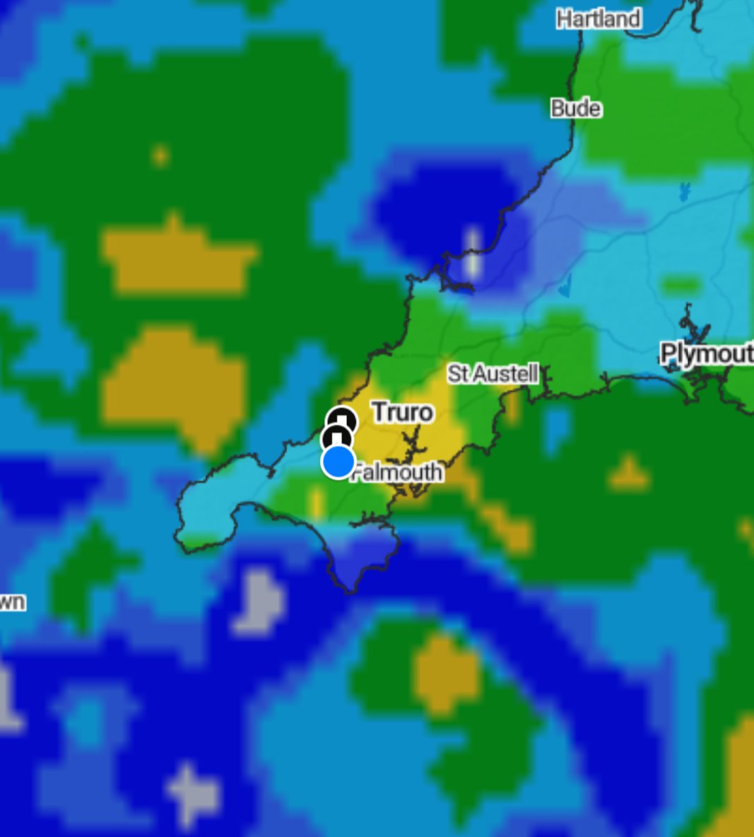
At the moment, the forecast suggests that outbreaks of rain could begin affecting Cornwall from around 8am on Monday, continuing at times until approximately 7pm.
We're expecting a mixture of light, moderate and potentially heavy rainfall, with some locations experiencing longer spells of persistent rain.
However, it doesn't necessarily mean it will be pouring continuously for eleven hours!
There could be some drier intervals between the heavier outbreaks, and rainfall amounts will vary depending on the exact track and timing of the approaching weather fronts.
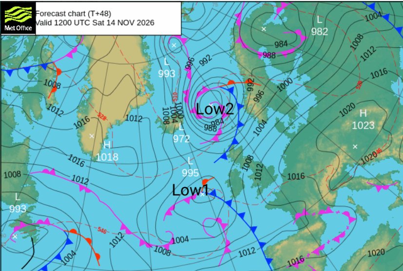
The rain is associated with a low-pressure system moving in from the Atlantic, bringing weather fronts across southwest England.
And after several relatively dry days, it looks as though our umbrellas are about to make a comeback!
I knew putting mine away was tempting fate!
Monday afternoon into Tuesday morning, winds are strengthening!
Now, this is another part of the forecast we're keeping a particularly close eye on.
As Monday progresses, southwesterly winds are expected to strengthen, with the windiest conditions potentially developing during Monday evening and continuing into the early hours of Tuesday morning.
At present, we're monitoring the possibility of wind gusts reaching 20–55+ mph, although not every location will experience the strongest winds.
Exposed coastal areas, headlands and higher ground could experience the more powerful gusts, while sheltered inland locations may see considerably lower speeds.
The exact strength of the winds will depend on the track and development of the low-pressure system, along with how tightly packed the isobars become.
And as many of you know from our previous weather explanations, tightly packed isobars generally indicate a stronger pressure gradient, which can produce stronger winds.
So yes, the garden furniture might need keeping an eye on again!
But there's some good news: temperatures are going back up!
After some rather cold mornings, with frost and temperatures dropping below freezing in parts of Cornwall, we're expecting a noticeable rise in temperatures.
Monday could see temperatures climbing to around 12–15°C.
That's quite a difference compared with the freezing conditions some locations have experienced recently!
The reason for this change is the southwesterly airflow, which will bring relatively mild maritime air in from the Atlantic.
But before anyone gets too excited about those temperatures, remember that 15°C accompanied by heavy rain and gusty winds isn't exactly beach weather!
What's causing this change?
Over recent days, high pressure has helped keep much of Cornwall relatively settled, allowing some clear skies, chilly nights and frosty mornings.
However, that high-pressure influence is beginning to weaken, allowing Atlantic low-pressure systems and their associated weather fronts to move closer to our shores.
We're also watching changes in the position and strength of the jet stream, which can help influence the development and movement of these systems.
From moor to shore, we've got Cornwall covered.
Brrrrr! It's certainly a cold and frosty start to Friday across much of Cornwall this morning!
Temperatures are ranging from a teeth-chattering -4°C to +4°C across Cornwall, with some locations waking up to a proper taste of winter!
With temperatures dropping well below freezing in places overnight, there's a risk of frost and icy patches, particularly on untreated roads, pavements and in sheltered countryside locations.
Meanwhile, the Isles of Scilly are enjoying a slightly milder start, with temperatures around 7°C this morning.
If you're heading out for the school run, travelling to work or taking the dog for a morning walk, please take extra care, especially on surfaces that may look wet but could actually be icy.
And if you're scraping ice off the car windscreen this morning, welcome to the November gym workout!
Stay warm and take care out there, everyone!
Kind regards,
KWT Dave
Well, would you look at that… the radar is actually looking nice and clear this morning!
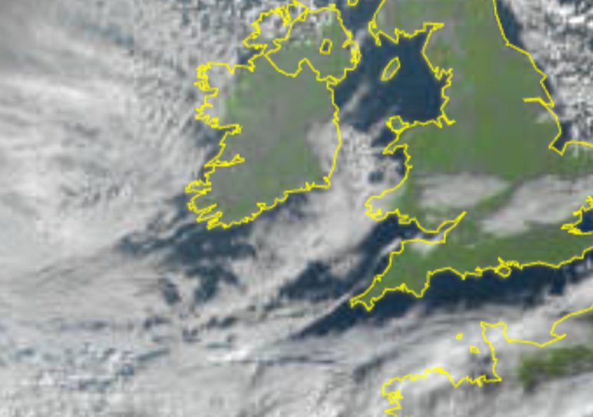
Looking at the latest radar image for Cornwall and the Isles of Scilly, there’s very little happening in the way of rain at the moment, and the latest Meteosat satellite image is looking pretty decent too.
The mist and fog that was hanging around earlier appears to have mostly cleared away, which means many of us are now seeing a much brighter start.
So this morning’s weather menu is looking something like this:
Sunny spells, a few clouds drifting around and yes… even some hazy blue skies!
There may still be a bit more cloud in places, because this is Cornwall and apparently we’re not allowed to have completely straightforward weather , but overall it’s looking rather pleasant out there.
A very nice change from some of the damp, gloomy starts we’ve had recently.
Enjoy the brighter weather while it lasts, everyone and yes, if you can see blue sky from your window, it really is there!
Kind regards,
KWT Dave
#Cornwall#Surf reports
Thursday is bringing another mixed bag along Cornwall's coastline. There's still some decent Atlantic swell around, but strengthening northeasterly winds could make conditions rather messy at exposed beaches.
Sennen looks particularly interesting today. The Atlantic hasn't gone back to sleep, but somebody has definitely switched the wind machine on!
Swell & wind
Main swell: SW to WSW, approximately 4–5ft at 9–11 seconds this morning, becoming increasingly mixed with shorter-period wind waves later.
Winds: NE to ENE, generally 20–35mph, with stronger gusts possible around exposed headlands.
Expect offshore conditions around Sennen, but more cross-shore and choppy surf at several north-coast beaches.
#Newquay & North Cornwall
#Fistral: 3–5ft, becoming more wind-affected.
#Crantock: 3–5ft.
#Holywell Bay: 3–5ft.
#Perranporth: 3–5ft, increasingly mixed conditions.
#Watergate Bay: 3–4ft, cross-shore winds.
#Mawgan Porth: 2–4ft.
#Polzeath: 1–3ft.
#Towan: 1–2ft.
#Great Western: 1–3ft.
There should be plenty of rideable waves, but don't expect yesterday's cleaner conditions everywhere.
Gwithian, Godrevy & St Ives
#Gwithian: 3–5ft.
#Godrevy: 3–5ft.
#Porthtowan: 3–5ft.
#Chapel Porth: 3–5ft.
#Porthmeor: 2–4ft.
#Hayle & Mexico Towans: 2–3ft.
Cross-shore winds could make the surf rather bumpy, particularly around Gwithian and Porthmeor.
West Cornwall
#Sennen: 4–6ft, powerful sets.
#Gwenver: 4–6ft, occasionally larger.
West Cornwall looks one of the better options, with offshore winds helping wave shape despite the gusty conditions.
Individual beach heights are estimated breaking surf, not measured offshore swell.
Best areas: Sennen, Gwenver and selected sheltered north-coast breaks.
Sea temperature
Approximately 14°C. A 4/3mm or 5/4mm wetsuit is recommended.
Best suited to intermediate and experienced surfers. Strong winds and powerful sets make exposed beaches unsuitable for beginners.
Sea safety: Watch for strong offshore winds, rip currents and unexpected larger sets. Check local conditions and bathing-water quality before entering.
https://t.co/6FEWSlbCAc
Have a cracking Thursday, everyone! Stay safe, enjoy the waves and don't forget that warm flask for afterwards!
Oceanic-Wave From Cornwall's coastline to the open ocean.
Good morning everyone!
Here are the latest temperatures recorded across Cornwall and the Isles of Scilly this morning, and it's certainly a chilly start for some of us!
Temperatures are currently ranging from around 0°C to 9°C, depending on your location, with some parts of Cornwall feeling rather nippy indeed!
With temperatures dropping close to freezing in a few locations, there could also be some patches of frost around, particularly in sheltered valleys and rural areas.
So, if you're heading out this morning, take a little extra care on untreated roads, pavements and country lanes, where there could be the odd icy patch.
And if you're still tucked up in a warm bed, I don't blame you one bit!
How cold is it where you are this morning? Have you spotted any frost?
Kind regards,
KWT Dave 🌦️
Why is Remembrance Day also known as Poppy Day? And what is the story behind the little red flower?
As we remember those who gave their lives for our freedom, have you ever wondered why we wear a little red poppy every November?
Well, behind this beautiful little flower is a story of heartbreak, courage, sacrifice and hope.
During the First World War, the battlefields of France and Belgium were devastated by years of fighting. The landscape was torn apart by shells, trenches and explosions, leaving behind fields of mud and destruction.
But something remarkable happened.
Among the shattered earth, where thousands of soldiers had lost their lives, bright red poppies began to grow.
Poppies thrive in disturbed soil, and their seeds can lie dormant underground for years. The fighting had brought these seeds to the surface, allowing them to grow across the devastated battlefields.
🌺 In Flanders Fields
In May 1915, a Canadian army doctor and soldier named Lieutenant Colonel John McCrae was deeply affected by the death of a close friend during the fighting in Belgium.
Inspired by the poppies growing among the soldiers' graves, he wrote one of the most famous poems of the First World War.
“In Flanders fields the poppies blow”
Those few words would help turn a simple red flower into one of the world's most recognised symbols of remembrance.
So how did Poppy Day begin?
Following the war, an American woman named Moina Michael was inspired by McCrae's poem and campaigned for people to wear red poppies in memory of the fallen.
A French woman, Anna Guérin, helped bring the tradition to Britain, where the British Legion adopted the poppy in 1921.
The first British Poppy Appeal took place that November, raising money to support former servicemen and their families.
And more than 100 years later, the tradition continues.
What does the red poppy mean today?
The red poppy represents remembrance, sacrifice and hope for a peaceful future.
Here in Cornwall and the Isles of Scilly, every November, our towns and villages gather around war memorials to remember the local men and women who served, those who returned and those who never made it home.
So the next time you see someone wearing a little red poppy, remember that it is much more than just a flower.
It is a promise that those who gave their lives will never be forgotten.
From the fields where poppies grow,
To the Cornish shores we know,
We remember those who gave their all,
And honour them, both great and small.
We will remember them.
🌺 Lest We Forget. 🌺
Kind regards,
KWT Dave and all the team ❤️
🌺 The 11th Hour, of the 11th Day, of the 11th Month Lest We Forget 🌺
Good morning everyone,
At the 11th hour, on the 11th day, of the 11th month in 1918, the guns finally fell silent.
After four long years of unimaginable suffering, destruction and loss, the First World War came to an end with the Armistice taking effect at 11am.
For millions, the silence that followed was something they had only dreamed of. No more thunder of artillery, no more whistles sending soldiers over the top, and no more endless sounds of battle.
But for so many families, that silence came too late.
Thousands of brave men from Cornwall left their little towns, villages, farms and fishing communities to fight for their country. Sadly, far too many never returned to the beautiful Cornish shores they called home.
Today, 108 years later, we remember them, along with all those who have given their lives in conflicts since.
At 11am today, Wednesday 11th November, we ask you to join us in observing two minutes of silence.
Wherever you are, whether at home, at work, walking along one of our beautiful Cornish beaches or standing beside a war memorial, please take a moment to remember.
🌺 The guns fell silent, the skies grew still,
Their names live on, and always will.
Across the land, across the sea,
We honour those who kept us free.
They gave their tomorrow for our today.
🌺 We will remember them.
Lest We Forget.
Kind regards,
KWT Dave and all the team ❤️
Here are the latest temperatures recorded from around Cornwall and the Isles of Scilly this morning, and I must say, they're not looking too bad for November!
Temperatures are currently ranging from around 6°C to 12°C, so it's a relatively mild start for many of us.
However, don't get too comfortable because Friday morning could be a completely different story!
We're keeping a close eye on the possibility of temperatures dropping to around −3°C in some sheltered parts of Cornwall, bringing a risk of frost and potentially icy patches, particularly on untreated roads.
Yes, it looks as though Jack Frost could be making an appearance, and he's certainly not coming to deliver the morning newspapers!
But back to this morning!
There are also some patches of mist and fog around Cornwall, particularly in sheltered valleys, rural locations and over higher ground.
So, if you're heading out on the roads this morning, please take extra care, allow a little more time for your journey and be prepared for locally reduced visibility.
Remember, fog can be quite localised. One village might have reasonably clear conditions while another just a few miles away is struggling to see much beyond the next field!
We'll continue monitoring Friday's colder outlook and bring you further updates as the forecast becomes clearer.
Have a lovely Wednesday, everyone, and stay safe!
Kind regards,
KWT Dave 🌦️
From moor to shore, we've got Cornwall covered.
#Cornwall#Surf reports
Wednesday is shaping up to be another promising day along Cornwall's Atlantic coastline, with a decent groundswell and easterly winds helping to keep several beaches clean.
The Atlantic is still serving up some chunky waves, especially around Sennen. Definitely not a day to leave your common sense in the car park!
Swell & wind
Main swell: WSW to SW, approximately 4–7ft at 11–13 seconds, depending on location, with a smaller NE wind-swell component.
Winds: Mainly E to ESE, around 10–20mph, locally stronger around exposed headlands. Offshore or cross-offshore at many north-coast breaks.
Surf should ease gradually through the afternoon, though plenty of energy remains.
#Newquay & North Cornwall
#Fistral: 4–6ft, easing to 3–5ft later.
#Crantock: 3–5ft.
#Holywell Bay: 3–5ft.
#Perranporth: 4–6ft.
#Watergate Bay: 3–5ft.
#Mawgan Porth: 2–4ft.
#Polzeath: 2–3ft.
#Towan: 1–2ft.
#Great Western: 1–3ft.
Fistral looks particularly promising, with offshore winds and some powerful, clean faces. SVRF Surf Forecast
Gwithian, Godrevy & St Ives
Gwithian: 3–5ft.
Godrevy: 3–5ft.
Porthtowan: 3–4ft.
Chapel Porth: 3–5ft.
Porthmeor: 2–4ft.
Hayle & Mexico Towans: 2–3ft.
Porthtowan looks a good option, with relatively clean surf throughout much of the day.
West Cornwall
#Sennen: 5–8ft.
#Gwenver: 5–8ft, potentially larger sets.
Some cracking waves are possible, but these are powerful conditions best left to experienced surfers.
Individual beach heights are estimated breaking surf, not offshore swell measurements. Local banks and tides will affect actual sizes.
Best areas: Fistral, Perranporth, Porthtowan and Sennen.
Sea temperature
Around 14-15c
Best suited to intermediate and experienced surfers. Beginners should seek smaller, supervised conditions.
Sea safety: Powerful sets, rip currents and offshore winds require extra care. Check local conditions and bathing-water quality before entering.
https://t.co/6FEWSlbCAc
Have a cracking Wednesday, everyone! Enjoy the waves, stay safe and remember those who served this Remembrance Day.
Oceanic-Wave —From Cornwall's coastline to the open ocean.
WEATHER UPDATE FOR WEDNESDAY
Good morning!
🌧It's a wet start for some as sunrise approaches, however any rainfall should clear away as daylight arrives leaving a cloudy and overcast day, some misty patches, with a light easterly breeze at 5 - 15mph and temperatures of 8 - 10 degrees.
☁Through lunchtime and into the afternoon, conditions look set to remain similar, overcast and cloudy, with the easterly breeze easing to 5 - 10mph and temperatures of 8 - 10 degrees.
↙️After sunset, the wind looks set to change direction and come in from the northeast, bringing a cool and calm evening.
☁Sunrise is at 0726hrs, and with some showers still hanging around through the work and school run, please go carefully as it's likely to be a bit of a grey morning; headlights on!
I'll be back with more later!
Have a great start to the day!
Annie, KWT
Just look at these incredible cloud formations captured by Gaby Gee at Morvah, West Cornwall!
Now, these are certainly some interesting-looking clouds!
The dramatic, layered formations have a striking resemblance to a shelf cloud, with those long, rolling, wave-like structures stretching across the sky.
So, what exactly is a shelf cloud?
A shelf cloud, also known as an arcus cloud, is a low, horizontal cloud formation that typically develops along the leading edge of a thunderstorm or a strong shower system.
It forms when cooler air spreading out from a storm pushes underneath warmer, moist air, forcing that air upwards. As it rises and cools, condensation creates the dramatic cloud structure.
Shelf clouds can sometimes signal the arrival of heavy rain, gusty winds or even thunderstorms, which didn't happen.
However, not every dramatic, layered cloud is a shelf cloud, and these photographs alone aren't enough to confirm the exact cloud type. They certainly have that shelf cloud-like appearance, though!
And I must say, the atmosphere looks as though it's been busy creating its own giant Cornish pasty in the sky!
What makes these photographs particularly fascinating is the way the different cloud layers appear to curl and stretch across the landscape, creating an almost ocean-wave appearance.
It really does show how incredible our atmosphere can be, even when the weather at ground level isn't doing anything particularly exciting!
A massive thank you to Gaby Gee for sharing these fantastic photographs and video footage from Morvah with the Kernow Weather Team.
We absolutely love seeing your weather photographs from around Cornwall and the Isles of Scilly.
What do you think of these formations? Have you ever spotted clouds like these over Cornwall?
Kind regards,
KWT Dave
From moor to shore, we've got Cornwall covered.
Good morning everyone,
Here are the latest temperatures taken from around Cornwall and the Isles of Scilly this morning, and it’s certainly feeling a little milder than some of our recent chilly starts.
Temperatures are currently ranging from around 6°C to 13°C, helped along by the southeasterly winds bringing slightly milder air across our part of the world.
So you might not need quite as many layers first thing today, although don’t put the winter coat too far away just yet!
Towards the end of this week, temperatures are expected to turn cooler again as our weather pattern changes, and we could notice more of that November chill returning, especially in the mornings and overnight.
There are also some patches of mist and fog around this morning, particularly in more sheltered locations and over higher ground, so please take a little extra care if you’re travelling where visibility suddenly drops.
For now, though, it’s definitely a milder Tuesday morning for much of Cornwall and the Isles of Scilly.
Kind regards,
KWT Dave.