Topsoil Moisture % Short/Very Short by
@usda_oce
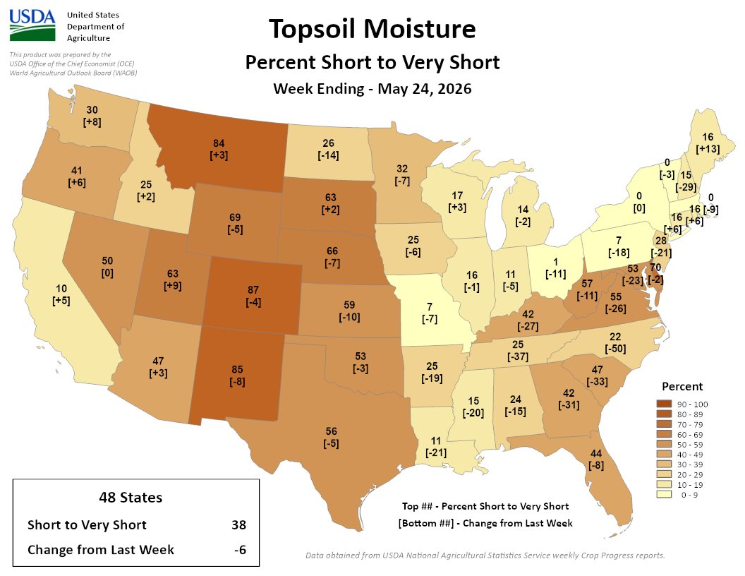
The Lower 48 saw a welcome 6% improvement over last week: 38% of the Lower 48 is short/very short.
While heavy rain brought relief to the Southeast, severe topsoil deficits remain in CO (87%), NM (85%) & MT (84%). #drought
I was a normal to slightly cool May by temperature standards. Precipitation was lackluster across the Upper Midwest, with the most precipitation across the Ohio River Basin.
Is it June or October? Cool was the rule this morning, as many stations saw temperatures tumble into the 40s, especially in the eastern region. The chilliest minimum reading was recorded at our site in Lewis County near Vanceburg...just shy of 45F! #kywx
The entire area should be dry for the next 48 hours, with no rain forecast. This will allow the few remaining rivers with higher water levels to continue receding, and no new river flooding is currently forecast.
@CoCoRaHS We appreciate everyone who has provided us feedback to help us build the best Mesonet for the commonwealth we can.
Thanks a bundle,
Andrew Q
The Mesonet Computer Person #kywx
@CoCoRaHS We now have a product that shows Mesonet rain totals from 7am-7am. Find out more about this program at https://t.co/Dkekyio9zz, and become a citizen observer today!
https://t.co/zyJo3k9VaH
We have a lot more products in the works and many are based on feedback from the community.
You can see the rain and heat as it sinks into the ground, it’s pretty neat stuff!
https://t.co/ZoccEikEeI...
https://t.co/oaiNoMQjFk...
@CoCoRaHS Formatted Rain Totals: We have created a new product to help support our community observers.
This was the #1 feedback we received after launching our new website. We really hope this will help folks out.
Data Heatmaps: For both temperature & precipitation/moisture, these heatmaps really improve visualizing and understanding what's going on above and below the ground.
🧵We have a minor website update with a few new features that just went live.
Home station selection: When you first visit https://t.co/aFQT3m5owx if you have not selected a home station you will now be given a prompt to help walk you through this process.
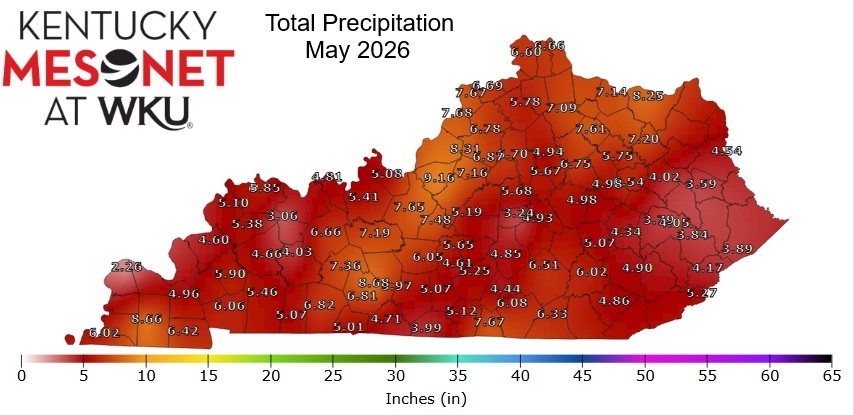
For perspective, average rainfall for March and April ranges between 4"-5" across the state. Several stations in the south-central and southeast portions failed to even reach that range for those two months combined. #kywx
🧵At the end of a meteorological #spring that had been remarkably dry for most of the Commonwealth, significant rainfall made a comeback at the end of May. Precipitation totals for last month exceeded those of the two previous months combined for many.
Little rainfall is expected across the region this week as high pressure and dry weather will dominate until this weekend when an unsettled weather pattern returns. Elevated river levels will continue falling this week, reducing the impact of the rain expected in days 6-10.
On this date in Weather History: Significant flash flooding occurred in the city of Paducah back on June 1, 2013 with 5.58". This was the 4th highest rainfall on record for a single calendar day. Meanwhile, back in 1917 F2 tornadoes struck the W KY counties of Graves & Hopkins.
@KYClimate@NOAADrought Webinars are regularly scheduled for the 1st THU of the month, with the opportunity of additional webinars in the case of drought episodes.
YouTube Channel: https://t.co/7MtB5gB4ig
Please let me know if you have any questions, and we look forward to seeing you THU at 2pm ET!#kywx
@KYClimate@NOAADrought Just click on the Zoom link below and then input the meeting ID and passcode below.
Zoom link: https://t.co/zL9IQEERqd...
Meeting ID: 945 6821 6001
Passcode: 957822
There is also the option to view the presentation live on our YouTube channel.
Happy Monday, June 1st everyone,
Please join us this THURSDAY (June 4th) at 2pm ET / 1pm CT as @wkuogden's Dr. Jerry Brotzge takes us through a look back at May, current conditions, and outlooks, followed by a time for questions and feedback.
That said, just as it takes time for drought to develop, it takes time for it to subside. Also, this week's update does not account for rain that has fallen since mid-morning Tuesday, when indices used in the U.S. Drought Monitor are tabulated. #kywx
The portion of the state officially in drought (D2 or worse) also declined by roughly 10%.
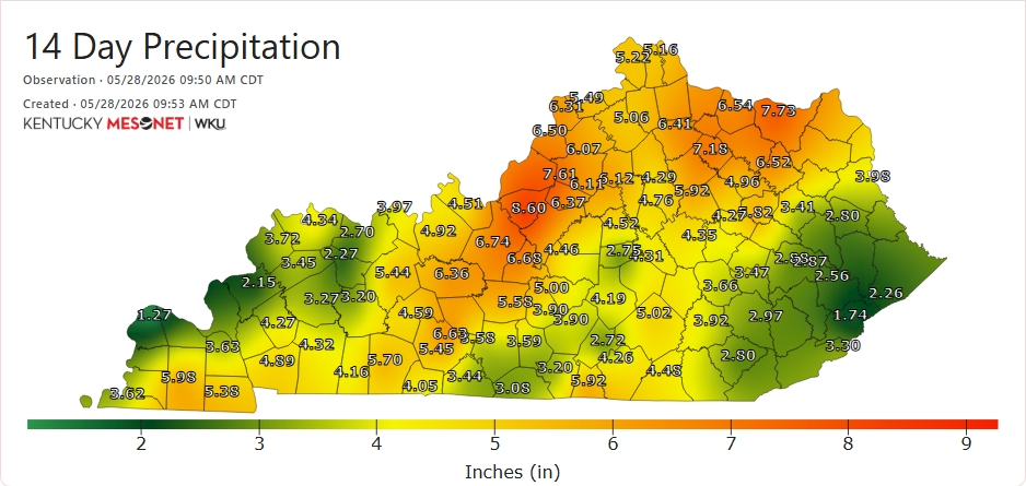
Rainfall amounts from the past week-to-14 days vary widely from county to county. However, many locations have seen rainfall accumulate over 5" in that period.
🧵This morning's updated #DroughtMonitor from @NOAADrought shows marked improvement from last week, thanks to significant recent rains. The most-expansive area of red - D3 (Extreme Drought) - shrunk from encompassing nearly half the state a week ago to now just ~ 5% of the state.
This is our 87th site in our 81st county. We are grateful for the partnership with Daviess Co. Fiscal Court & the Daviess Co. Emergency Management Agency for helping to make this happen!
We aren't stopping here. More growth is planned for our network in 2026...stay tuned!! #kywx