SeminoleSAFE (a.k.a. KeepFSUSafe) is your source for safety information, preparedness education, crime prevention tips and more from Florida State University.
Tradition will take the spotlight at FSU Homecoming 2026! Florida State University will host a series of Homecoming events Nov. 13, through Nov. 21, to honor tradition, foster connections and recognize alumni achievements.
Students, parents, alumni, friends and community members are invited to be part of the Homecoming parade and Seminole LIVE! 175 Carnival, on Friday, Nov. 20.
For info and schedule, visit https://t.co/Agxn6aSieL
11/13 4 PM ET/4 PM CT: BRRR! The coldest night of the season so far is on tap for tonight. Parts of SE AL, SW GA, and NW FL could see the first frost of the season with lows in the mid 30s tonight.
Protect People, Pets, and Plants, and Practice Fire Safety. #ALwx#FLwx#GAwx
There has been a temporary telecommunications outage - out of an abundance of caution all flights have been halted. Every flight has been accounted for and international flights will be handled on a case by case basis.
11/1/26 8AM EST ☔⏳🔮
How is it November already??😮💨 Also, Daylight Savings Time is done, as we've fallen back to Standard Time. 🔙
We kick things off today with...RAIN, after a dry October. A more progressive weather pattern is upon us. 🎢
#FLwx#GAwx#ALwx
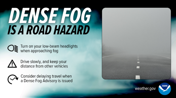
🚗⏱️ Dense fog greatly reduces the time you have to react to hazards or other vehicles in the road.
It's important to reduce your speed when encountering dense fog to increase your time to react!
Being on time to your destination is not worth your life.
#FogSafetyAwarenessWeek
10/20/26 ⚠️🌫️ Dense fog is a road hazard!
Slow down, increase your following distance, and allow extra commuting time. Use your low-beam headlights. In near-zero visibility, turn on hazard lights and immediately find a safe stopping place off the highway. #FogSafetyAwarenessWeek
10/19/26 8AM ET 🌡️☔🔮🎲
One of the stronger El Niño events on record is here to stay into early next year: https://t.co/thE733aYqX
This phenomenon is highly likely to make for a wetter-than-normal winter 2026-2027, per NOAA's outlook: https://t.co/U7yG5sVN9E
#FLwx#GAwx#ALwx
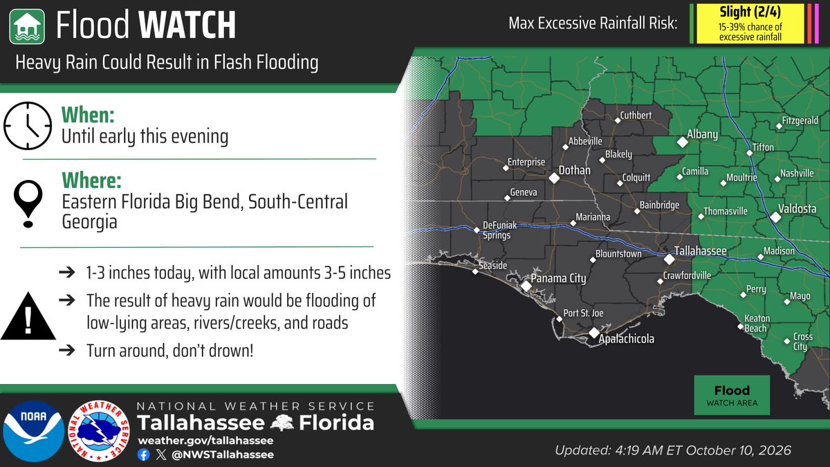
10/10 550 am ET: Isaias weakened overnight and is now post-tropical. All Hurricane and Tropical Storm Warnings have ended. We are left today with a lingering threat of heavy rain and a tornado or two over the eastern Big Bend and south-central GA. #FLwx#GAwx#ALwx
355pm - The favorable environment for tornadoes still remains offshore as evidenced by this strong cell's broadening rotation. However, this favorable environment is lifting north. Tornado threat will increase into the late afternoon and evening across the Florida Big Bend. #FLwx
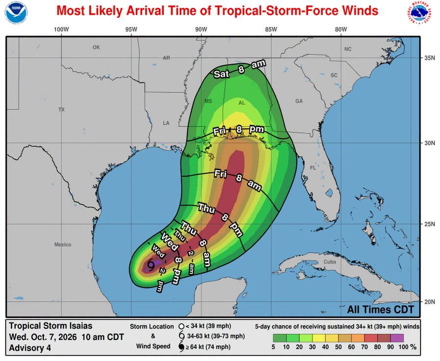
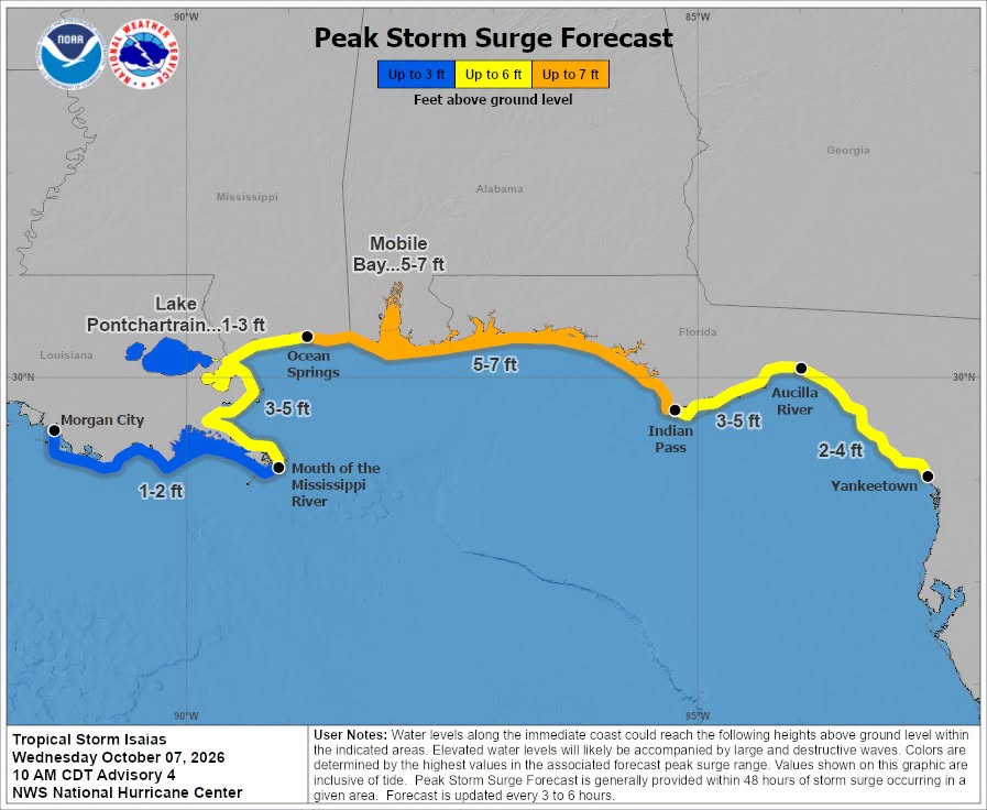
11am Isaias Update: Tropical Storm/Hurricane Watches now in effect for many coastal locations across the northern Gulf. Storm surge watch in effect as well. #FLwx#ALwx#GAwx
Motorists are urged to avoid the area and use alternate routes as emergency crews respond. Lanes are currently closed along North Monroe Street from Apalachee Parkway north to Park Avenue and east to Franklin Boulevard.
The Tallahassee Police Department is currently assisting the Tallahassee Fire Department with a fire-related incident in the downtown area, east of the Capitol complex near the Leon County Courthouse.
10/3/26:
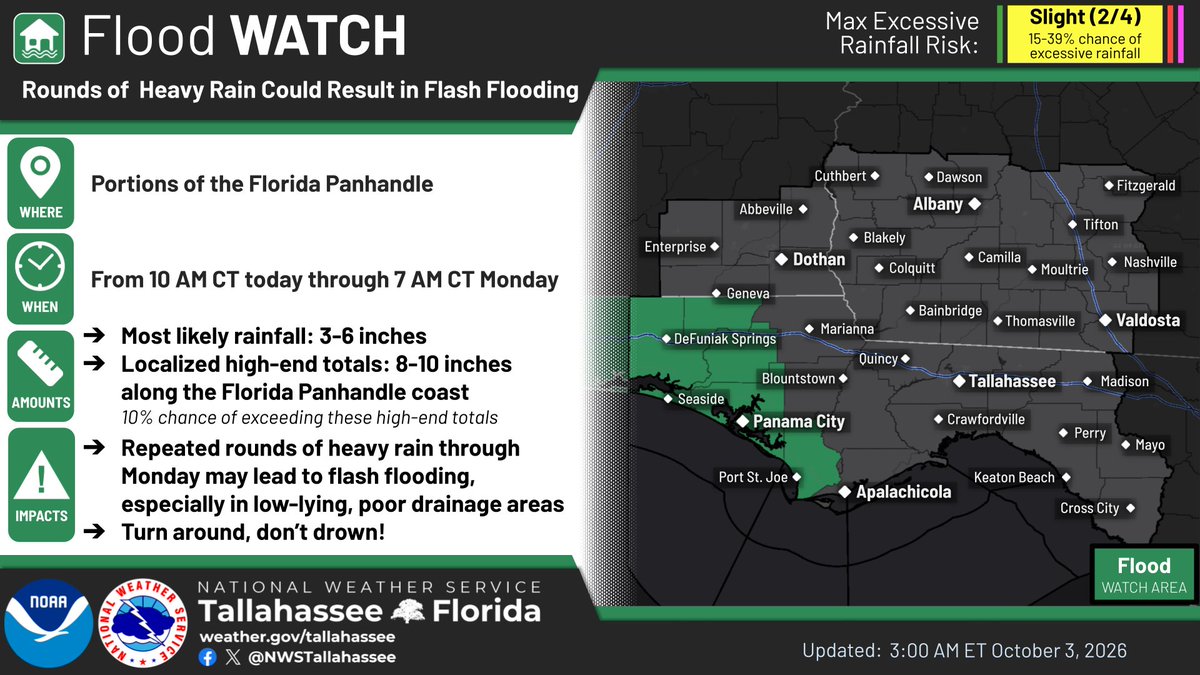
A Flood Watch is in effect for portions of the FL Panhandle this weekend into early Monday morning. Rainfall totals will generally rain between 3" to 6" in this area with locally higher amounts of 8"+.
Elsewhere, 2" to 5" of rain are forecast the next few days.
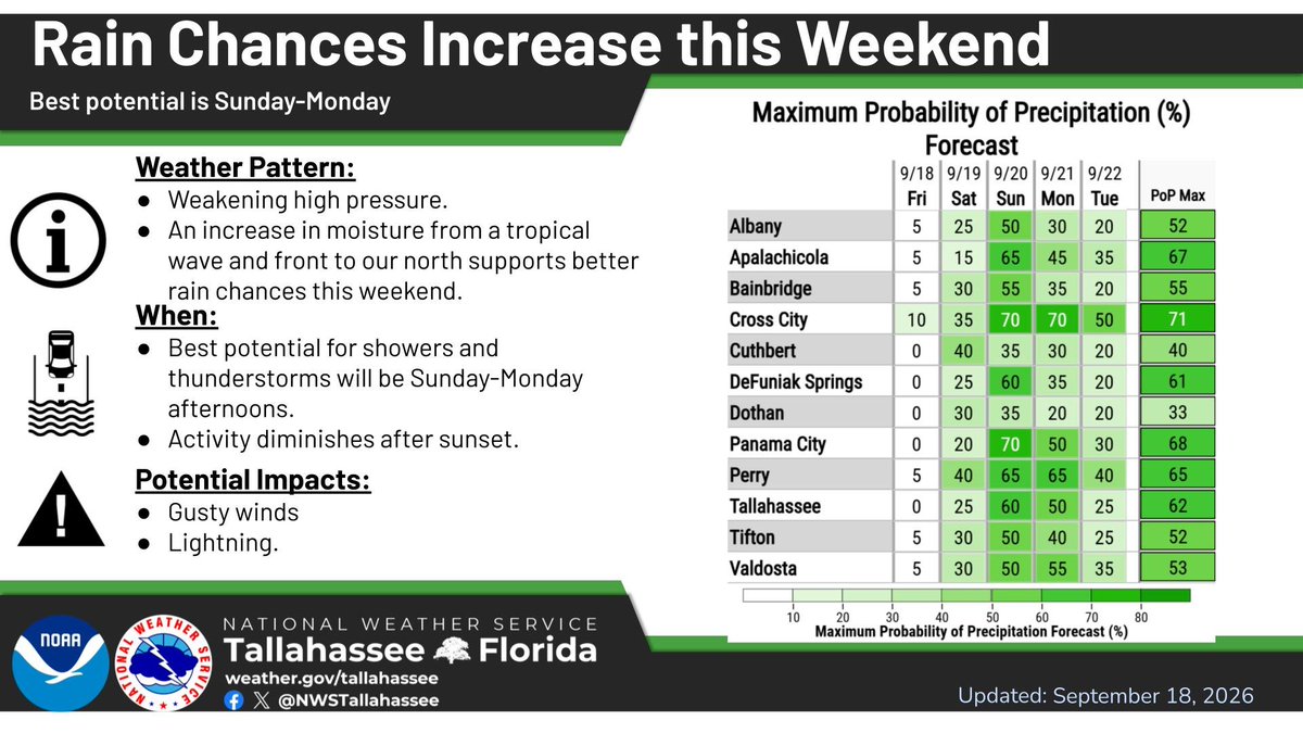
9/18/26 8AM ET 🌧️📉🔮
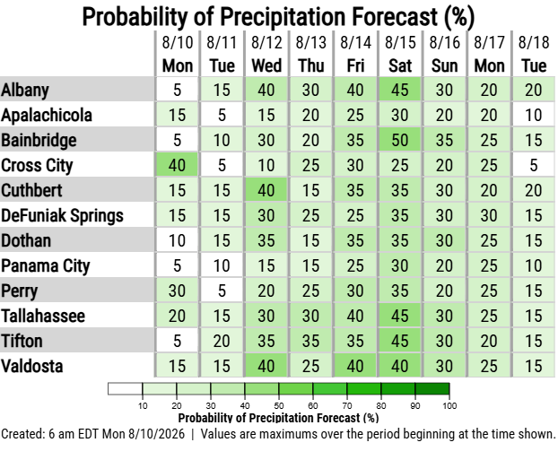
After a dry couple of days, rain chances are on the rise this weekend into Mon. Scattered showers/storms return as high pressure weakens and a tropical wave moves from the FL Peninsula into the East Gulf.
#FLwx#GAwx#ALwx
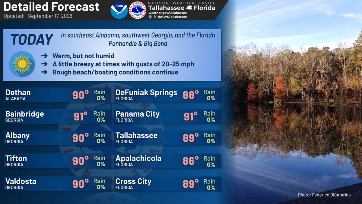
9/17: We're waking up to some crisp air, especially north of I-10 where many places are in the 60s. We'll reach the high 80s/low 90s with mainly sunny skies and a bit of a breeze. Rough beach/boating conditions continue today, but should improve in a day or two. #ALwx#FLwx#GAwx
8/21/26 6am ET
There is also another Heat Advisory in effect for the FL Panhandle & Big Bend, SE Alabama, and southern Georgia.
Showers and storms are forecast to blossom this afternoon with the potential to see strong gusty winds up to 60 mph.
#FLwx#GAwx#ALwx
8/20/26 7am ET
There is a Marginal Risk of Severe Weather (level 1 of 5) this afternoon and evening for the potential to see strong gusty winds up to 60 mph. ⛈️
There is also another Heat Advisory in effect for the FL Panhandle & Big Bend, SE Alabama, and southern Georgia. 🥵☀️
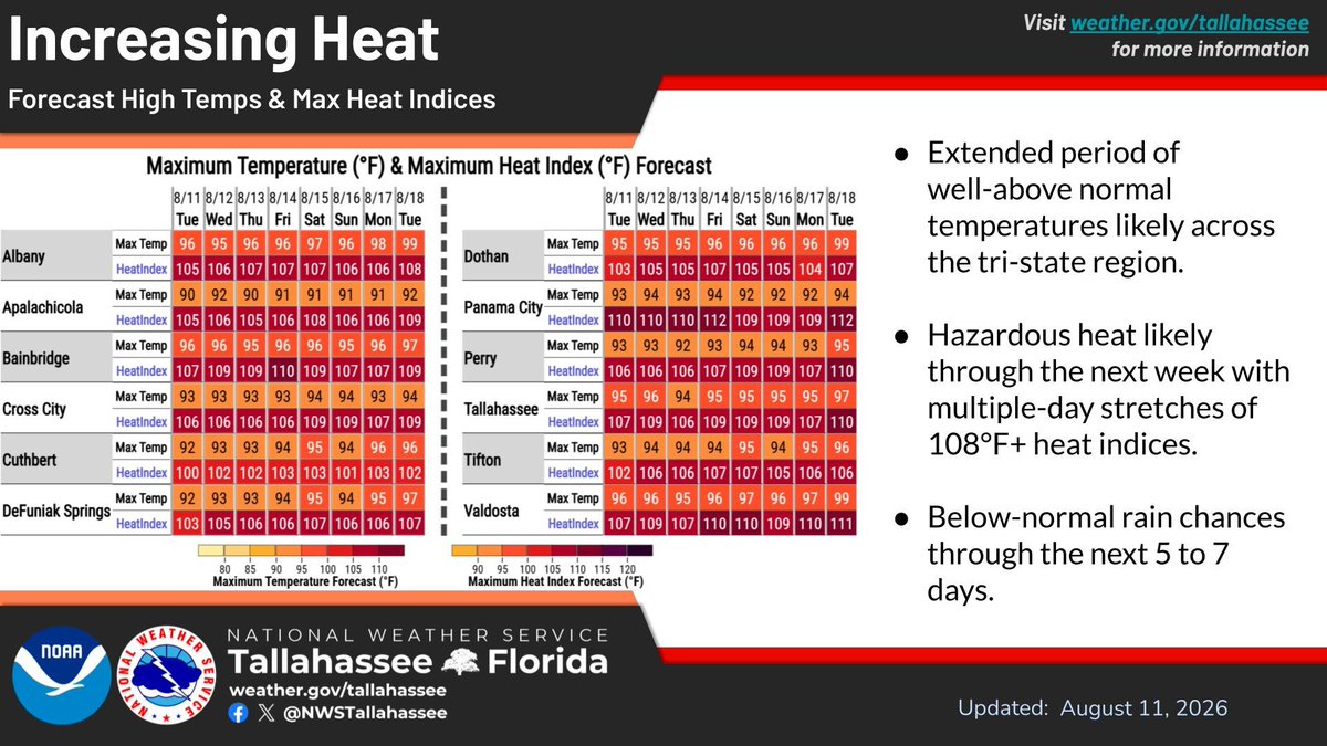
Temps will warm up and remain that way for an extended period of time as high pressure controls the prevailing pattern. Expect multiple days of hazardous heat with heat indices of 105-110.
#FLwx#ALwx#GAwx
As high pressure settles into the region the next few days, conditions will warm up while rain chances stay fairly isolated/scattered. Some heat index concerns creep into the forecast late in the week. #FLwx#ALwx#GAwx