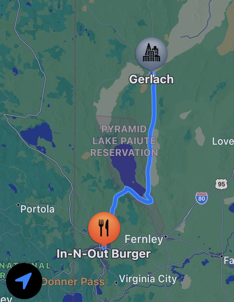
@bmantraffic For all those clueless ( everyone ) to where Patrick on Interstate Route 80 west bound, it is between Fernley/Wadsworth and Sparks/ Reno. Take the 445 / Pyramid Way route instead.
@bmantraffic From Bruno’s in Gerlach it is about 60 miles to 446 / Sutcliffe Hwy. Pyramid way actually intersects with 80 in Sparks not Reno. The In-N-Out in Sparks can be a faux end point for apple maps or can be selected as an alt route with google mapping routing.
@bmantraffic Avoid the 80 closure for West bound travelers is to take 446 ( West) in Nixon ( it’s the intersection with the gas station ) then turn Left on 445 South bound / Pyramid way down to 80 in Reno.
@SaltyConstitut2@bmantraffic I guess reading is not Saltys top skill “The Burning Man organization’s advice is for participants to delay their departures to avoid getting stuck in the mud, but people are free to leave should they choose to do so.”
@Jimmyhat911@bmantraffic BMIR around 6 pm that 300 vehicles are stuck in the mud that attempted to drive out. All of them blocking future outbound traffic / roads when conditions allow. People can walk out, if up to it. BLM permit likely requires that damage to the playa not be incurred when it is muddy
@bmantraffic Well you could look at this post and see there are solid reasons to stop the vehicles. Cluttering up the exit road with stuck vehicles makes everything worse when things dry out. https://t.co/HBnznQhiY7
Lot of stuck vehicles trapped by mud about a mile out attempting to exit from Burning Man. I just walked by about 30 various RVs and cars that can’t move.
⚠️ BAD WATCHDOG UPDATE!⚠️
Last week was the first time DHS IG Cuffari testified in front of Congress since #BadWatchdog was released. And in case you haven't heard, the hearing was a doozy.
@schwellenbach & @MarenMachles are here with a recap: https://t.co/bCWPYkuC4p
@FutureBoy 4.0 Quake (1st report at USGS) ! Or maybe 3.6 (2nd report)? From the south someplace. Looks like it was the Hayward fault epicenter and just 3.6 miles from my house
https://t.co/vcgZdE3Dh1
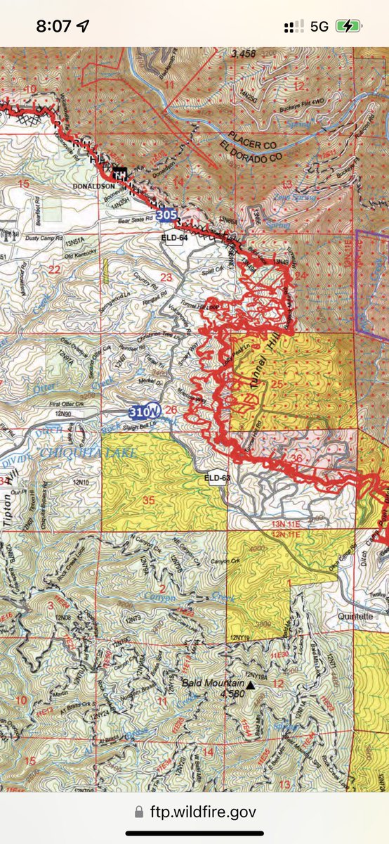
@CAFireScanner I don’t know if your google map is less accurate ( is it using hexagon quadrants instead?) than the image you published but the two don’t match. If the g map is true the fire has crossed Wentworth Springs rd at last - a big deal. Means my pals place is now gone.Heartbreaking.
@Tiffni1971@dawnification Where do mean gone ? These are is the best publicly available maps that I can find of the fire line this am in that area. I’m not sure what the yellow sections mean / are. If anyone can help clarify please do.
@CountyElDorado Next time please take care to place the streaming camera close to the speakers & maps - the maps were unreadable from the back of the room where the camera was placed. Perhaps even move the camera during filming for best view points.
@stacey_hb_ It’s all really helpful. Thank you so much. Nothing to apologize for or be sorry about. Get some good rest. We all try our best to do what we can do.
@stacey_hb_ Well that is a relief. Looks like the fire has not crossed Wentworth Springs Road yet - comparing to your previous image 9 9 1150 the image is at a little different scale. So using geography as reference. Thx for adding the streets previously.