Public Information Unit -- Lee's Summit MO Police Department This account is not monitored 24 hours a day, if you have an emergency, call 911 or 816-969-7390 #7
🌡Cold front moves through the area Wednesday and will push temps below normal by Thursday and onward.
🌬 Cold front will turn winds out of NW with speeds to around 20 mph and gusts to around 30 mph.
🌦 No notable rain chances until at least the latter half of the weekend.
Rather calm weather this week. Warm early on with more seasonable temperatures by Thursday and into the weekend. Breezy winds on Wednesday. #mowx#kswx#KC
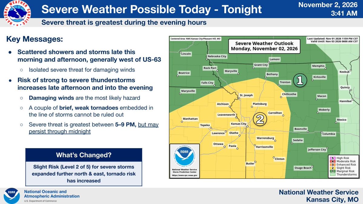
Severe storms are possible from this afternoon into the overnight hours. The severe weather risk is greatest from 5 to 9 pm, but may persist through midnight. Damaging winds are the most likely hazard but a few tornadoes are possible embedded within a line of storms.
When a driver is texting and driving, they are 23 times more likely to be in a critical incident (source: VA Tech). NOTHING is more important than each of us getting home safely, so put the phone down!
It's Halloween week! 🎃
Parents, remind yourselves that some costumes — similar to puffy coats — have excess material and can prevent a car seat from keeping your child SAFE in a crash.
Don't risk it — change them into their costumes at your destination. 🦄✔️
JACKSON COUNTY – MoDOT will be conducting a ramp closure from WB I-470 to SB MO-350 on Thurs., Oct. 22nd from approximately 9:00 am until 3:00 pm for lighting repairs. Motorists are encouraged to seek an alternative route. All work is weather permitting. https://t.co/yWB2CsnfXT
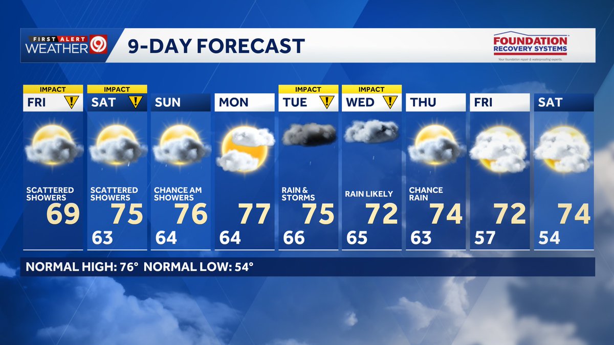
⚠️ Today is the first of several First Alert Weather Impact Days expected through next week. That being said, keep your outdoor plans this weekend!
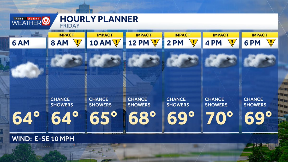
🌧️ Friday: Scattered light rain showers are likely through early afternoon. Lightning is unlikely during this time. Drier conditions will prevail late this afternoon and evening, though a lingering rain shower can’t entirely be ruled out.
🌧️ Saturday: Scattered showers with intermittent downpours are likely during the morning and early afternoon, with a low chance of lightning. Once again, drier conditions should prevail during the late afternoon and evening, though a lingering shower can’t entirely be ruled out.
🌥️ Sunday: Aside from scattered showers early in the morning, the remainder of the day should stay dry, albeit mostly cloudy.
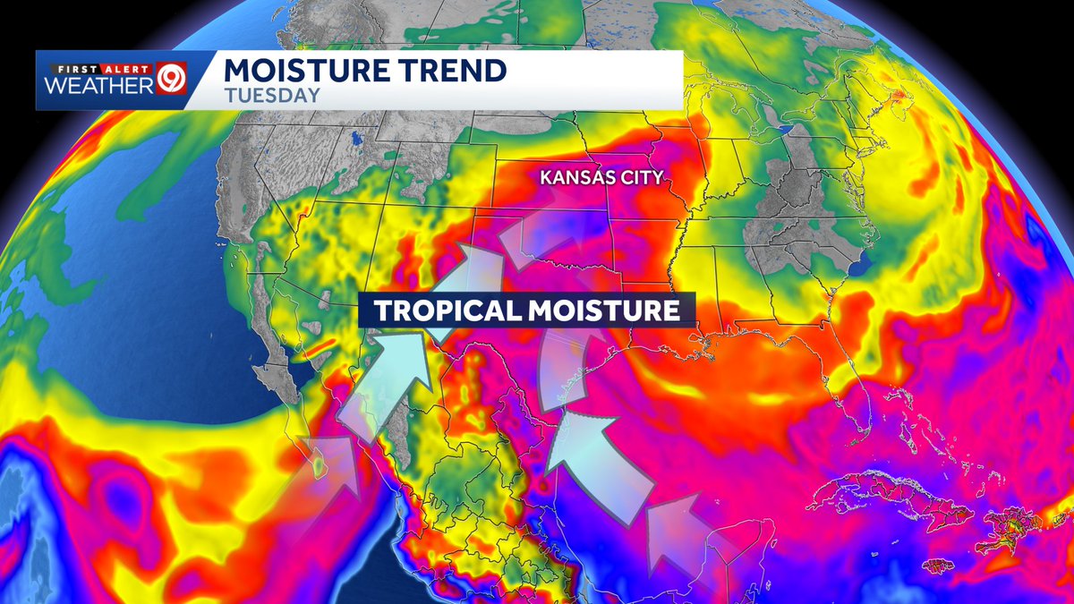
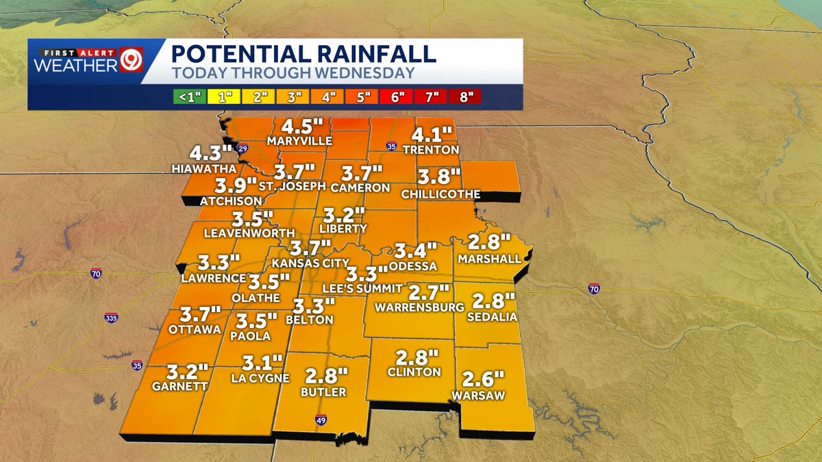
🌀 Our focus next week will be on a pair of Impact Days on Tuesday and Wednesday. A cold front may get a boost of tropical moisture from the remnants of Hurricane Polo as it crosses the mountains of Mexico and moves into the Plains. Periods of heavy rain and thunderstorms are likely during this time.
Posted Friday, September 25, 2026.
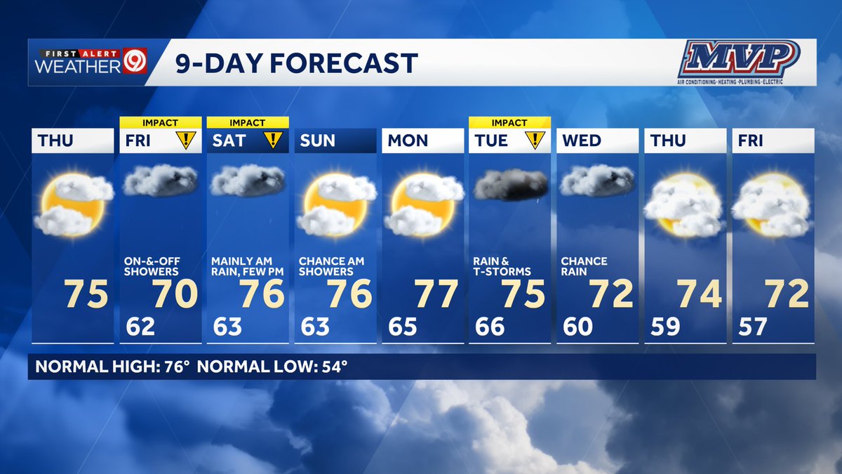
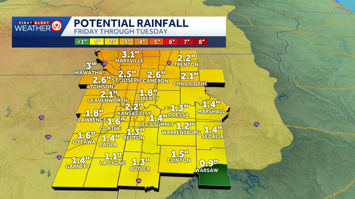
⚠️ Three First Alert Weather Impact Days have been issued for this weekend and next week: Friday, Saturday, and Tuesday. Let’s take it one day at a time!
🌦️ Friday: It won’t be a washout! I don’t anticipate widespread, prolonged, or heavy bouts of rain, and even the chance of lightning is very low. That said, a brief downpour could occur at any time during the morning, afternoon, or evening. Keep your outdoor plans, but be prepared with an umbrella or rain jacket in case a shower moves over your venue or event.
🌧️ Saturday: This is emerging as the rainiest day of the weekend, though conditions will vary greatly by location. Communities west of I-35 across northeastern Kansas and northwestern and north-central Missouri can expect longer-lasting downpours, with the potential for embedded lightning strikes Saturday morning. The rain could taper off, leading to drier conditions Saturday afternoon. Communities such as Kansas City and those in central Missouri should also be prepared for downpours and some lightning strikes Saturday morning, with lower chances Saturday afternoon and evening. I’m more concerned about your morning plans being disrupted than your afternoon plans, but I still wouldn’t cancel your outdoor activities just yet—unless you have to make that decision today (Thursday).
⛈️ Tuesday: The active weather pattern will continue around the middle of next week as a series of storm systems and cold fronts brings enough lift, moisture, and instability to produce widespread rain and isolated thunderstorms.
Yesterday was Day of Remembrance bringing loved ones and colleagues together to honor those who gave everything in service to Missouri.
A special thank you to our guest singers, Officer Nathan Cantrell with @LSPDPIO and Lieutenant Barry Kumpf with @MSHPTrooperA.
School buses are designed with safety in mind — from flashing stop-arms to high-visibility yellow paint and protective seat backing — but it's more dangerous for students to get ON and OFF the bus. 🚏
Here's how you — the driver — can help keep our kids even safer:
🛑 Stop for school buses.
🚸 Slow down in school zones and near bus stops.
📵 Stay focused and put away your cell phone.
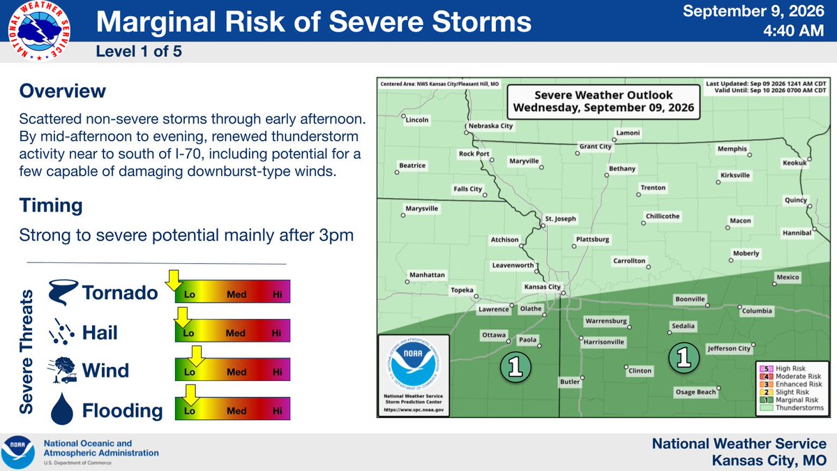
While the cold front slowly, agonizingly in some cases, drops through the state, there too will be the chance for a few strong to severe storms.
𝗪𝗵𝗮𝘁 - Strong/damaging winds (including downbursts)
𝗪𝗵𝗲𝗻 - ~3pm - 10pm
𝗪𝗵𝗲𝗿𝗲 - near and south of I-70
#kswx#mowx
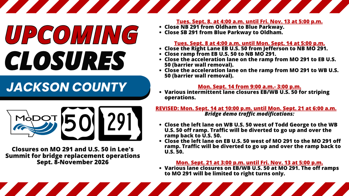
EVISED CLOSURES: Closures on MO 291 and U.S. 50 in Lee's Summit for bridge replacement operations Sept. 8-November 2026. DETAILS HERE: https://t.co/MCUhbWfnmG
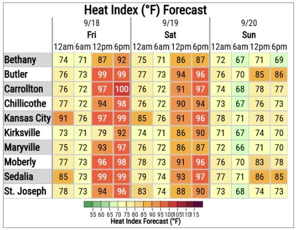
🥵🌡️ Renewed heat today ... but just one day for most of the area.
😎🌡️ Cold front begins to move across the area overnight tonight and Wednesday.
⛈️ Shower and storm chances tonight and Wednesday as the front moves through. Strong/damaging winds and mostly small hail possible.
This Labor Day weekend, remember that your plans shouldn't cost lives — yours or others.
If you plan to drink, make sure your plan includes a safe way home before the first sip:
⭕ Schedule a rideshare
⭕ Call a taxi
⭕ Have a sober friend drive you home
Drive Sober or Get Pulled Over. 🚔