☀️ Plenty of sunshine today, topping out near 88°. Sunday brings heat, humidity, and late-day storms, some strong. Monday cools to the upper 70s with sun and a light breeze. Mostly quiet early week before scattered storms midweek.
⛈️ Hot & humid today with sun early, then showers & t-storms likely. Some storms cold be severe this evening. High 93° with heat index above 100.° Saturday offers relief with sunshine & temps in the upper 80s. Storm chances return Sunday, then next week trends cooler & mostly dry
⛈️ Hot and even more humid today. Highs around 93; strong storms possible late with gusty winds and flooding rain. Friday brings more heat near 93° and afternoon storms. Weekend turns sunny and less humid with highs in the upper 80s before showers return Sunday night.
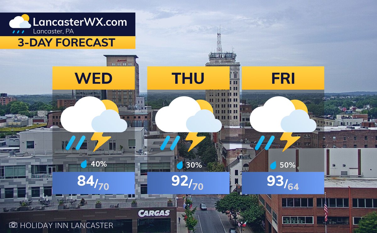
⛈️ Humid with clouds, sun breaks, and scattered showers or a thunderstorm. High 84°. Hot tomorrow near 92° with heat index over 100 and a chance of afternoon storms. Stormy Friday, then sunny and less humid for the weekend with highs in the upper 80s.
🌤️ Comfortable start today with sun and clouds, high 80°. Warmer tomorrow, high 84°, staying mostly sunny. Heat and humidity surge midweek with storms likely Wednesday, then highs push into the 90s Thursday and Friday before slowly backing off into the weekend.
☀️ Mostly sunny and hot today, High 91°. Saturday stays hot near 92° with late-day storms rolling through. Storms fade overnight with patchy fog, then sunny and warm Sunday. Early next week stays above normal with mostly dry, summerlike weather.
☀️ Sunny and comfortable today, high 83. Tomorrow turns warmer with sunshine and a high near 87. Big heat builds Friday and Saturday with highs into the 90s before showers and storms arrive late weekend bringing a cooler trend early next week.
🌤️Morning showers then becoming sunny & breezy today with a high near 75.° Tomorrow stays sunny & warmer with highs in the upper 70s. Expect a cooler but sunny Saturday in the 60s, then warming into the 70s Sunday. A dry & comfortable pattern dominates into the start of next week
🌥️ Foggy start then partly sunny with a high near 81°. A few scattered showers arrive late tonight. Tomorrow stays mostly cloudy with patchy morning fog and scattered showers, high near 79°. Sunshine and cooler, drier air return Thursday and last through the weekend.
🌥️ Morning rain and patchy fog giving way to slowly clearing skies this afternoon. High 78°. Tomorrow turns mostly sunny and warmer near 80°. Midweek brings a mix of clouds and scattered showers south, but a dry, pleasant stretch builds late week with highs in the 70s.
🌧️ Rain showers return overnight. Showers continue tomorrow morning, tapering around mid-day. Memorial Day will be mainly cloudy, warmer (75°) & more humid. Expect some clearing in the afternoon. A stray shower or storm may develop later in the day as a cold front crosses.
🌧️ Cool and damp today with periods of rain tapering by late afternoon. High 61°. Tomorrow stays mostly cloudy with spotty showers and a high near 60°. A wet, chilly Saturday ahead before showers taper Sunday. Temps begin to trend warmer Sunday & Monday but still below normal.
🌦️ Summerlike heat today turns stormy by afternoon with a high of 91°; a few storms may be strong. Cooler tomorrow with showers likely, high 66°. Big cooldown continues into the weekend with steady rain Friday and Saturday, highs only near 60°.
☀️ Hot and sunny today with a high near 95°, heat index near 100.° Scattered storms may pop up late. Tomorrow brings showers and a rumble of thunder with a High near 92.° Big cooldown arrives Thursday with highs in the 60s and a damp, rainy start to the holiday weekend.
☀️ Hot and mostly sunny today with a high near 95°, near record levels. Tomorrow may be even hotter around 97° with a light southwest breeze. Strong cold front Wednesday brings showers and storms, then temps tumble to the 60s by Thursday for a cooler, unsettled stretch.
☀️ Breezy start with some clouds then mostly sunny today, high 70°. Saturday warms quickly with sunshine and highs near 81°. Heat builds Sunday into the 90s Monday and Tuesday, the hottest so far this year, before midweek showers cool things back to springlike levels.
🌥️ Breezy and cool today with clouds and a few spotty showers. High 59°. Tomorrow turns partly sunny and milder, near 68°. Weekend warms quickly with highs in the 80s, mostly dry. Big summerlike surge into early next week with highs pushing upper 80s to 90.°
☀️ Cold this morning then sunny & pleasant with a high near 68.° Clouds increase tonight. Showers arrive Wednesday with a few late-day storms, high 73.° Showers linger Thursday, then drying and warming into the weekend with highs in the 80s by Saturday.
🌤️ Cloudy this morning, then turning mostly sunny with a high near 63.° Tomorrow stays sunny and a touch warmer around 67.° Showers and a few rumbles of thunder arrive Wednesday into Wednesday night, then clearing and cooler Thursday before a warm, dry weekend ahead.
🌦️ Morning rain and drizzle a few afternoon showers, High 68°. Sunday turns warmer near 74° with a few stray showers. Cooler and breezy Monday with lingering showers, then clearing and sunny by Tuesday as a stretch of dry, cool weather sets in.