*HEALTH REMINDER* The City of Leander is communicating regularly with regional partners like @WCCHD regarding Coronavirus (COVID-19) status. Consider following these health organizations for more updates and info: @WCCHD, @TexasDSHS, @CDCgov
The severe thunderstorm watch has been cancelled for Leander and Williamson County. Stay aware while driving this morning. Some low water crossings may still have water across them after storms have passed.
#DriveSafely#PreparingLeander
Lightning and gusty winds can lead to power outages. Monitor the outage map, check outages, and report outages at @PedernalesCoop via their outage map here: https://t.co/6V9uGutEa6
We've gotten reports of very low visibility in heavy rain. Please be careful. Slow down, leave extra space between you and the vehicle in front of you.
A look at the line of storms as it moves towards the I-35 area. If commuting over the next few hours:
-Slow down in heavy rain
-Turn headlights on
-Brake sooner and add extra space between cars in front of you
-NEVER park under overpasses
https://t.co/eSuCW5gVau
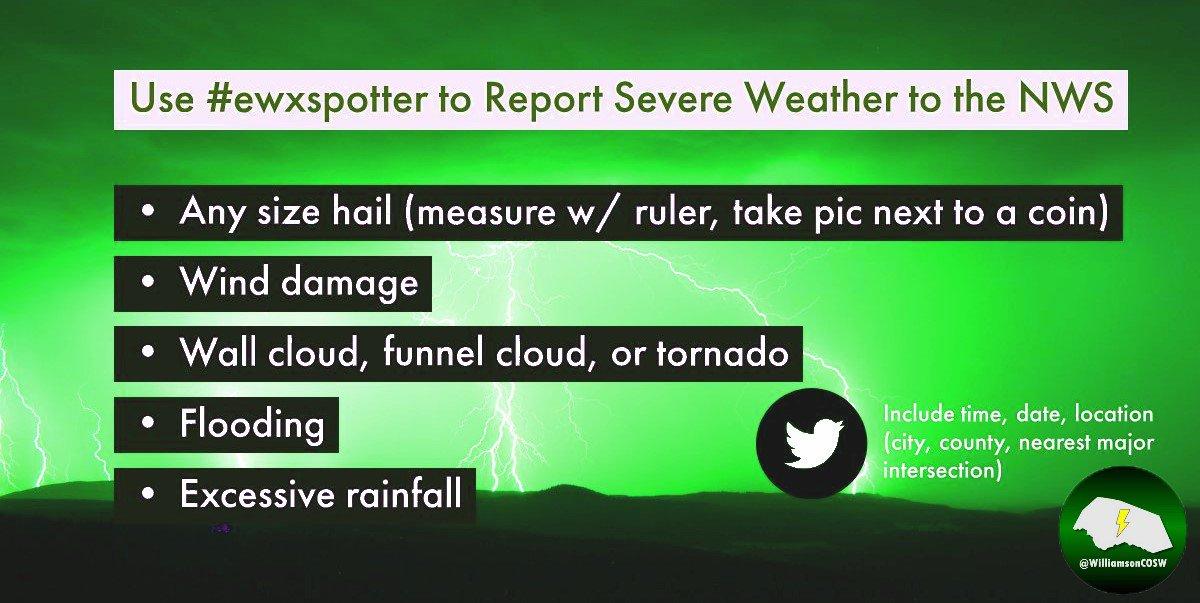
If you receive storm impacts this morning, please tag tweets with #ewxspotter and include cross streets of damage location.
Reports that are helpful include:
-Hail damage to structures, vehicles, or objects
-Wind damage to structures, fences, or trees
-Flooding on roads
If you receive storm impacts this morning, please tag tweets with #ewxspotter and include cross streets of damage location.
Reports that are helpful include:
-Hail damage to structures, vehicles, or objects
-Wind damage to structures, fences, or trees
-Flooding on roads
Reminders on severe thunderstorm safety:
-Shelter inside a sturdy building away from windows
-Drive carefully if on roads, NEVER stop under overpasses
-Protect self from lightning and damaging straight line winds
#PreparingLeander#TStormSafety
If you receive any wind damage or any large hail, please forward any photos or reports to our account. Be sure to only make reports SAFELY after the storm has passed. During the storm, take appropriate shelter actions from severe storms:
https://t.co/hgWmZhRxhM
If anyone is seeing wind damage or hail bigger than quarter size, send us reports via Twitter, Facebook, or phone call.
Wind threat increasing for northern Kendall County and southern Gillespie County.
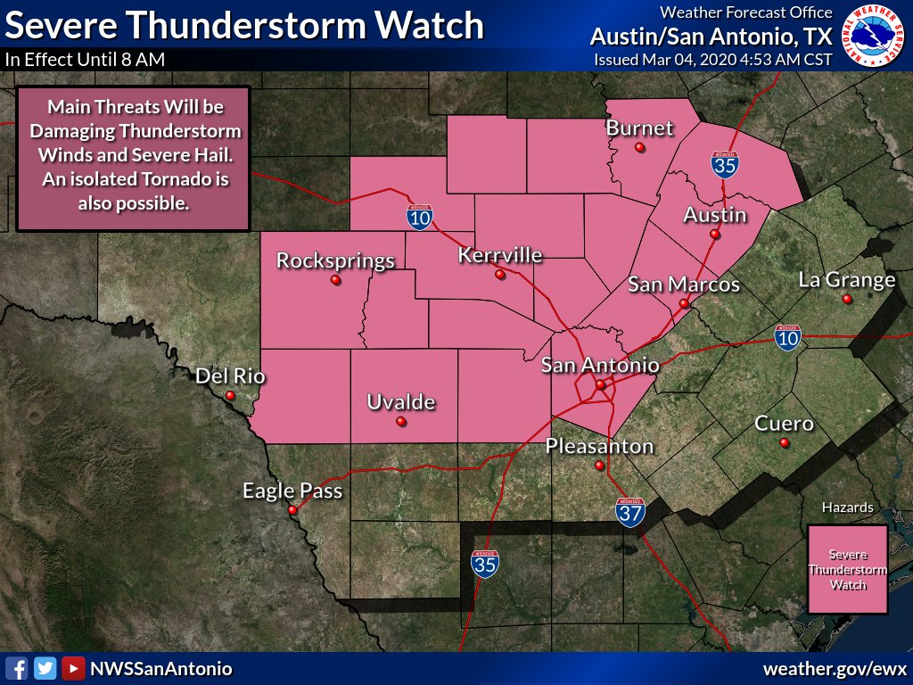
Severe Thunderstorm Watch has been expanded east and now includes the I-35 corridor. This watch expires at 8 AM with the main threats being damaging winds, severe hail, and an isolated tornado.
Be weather aware as you plan to head out this morning for your commute.
[3/4/20]: The National Weather Service has issued a severe thunderstorm watch for Williamson County until 8 AM. A line of storms is approaching from the west. Stay tuned to the weather as you start your morning commute.
https://t.co/ZDIqxRC8GX
Severe storms continue to track east this morning. Moving in to Gillespie, Kendall, Medina, and Llano County. Strong winds in excess of 60 mph, penny size hail, frequent lightning, and brief heavy rainfall are the main hazards.
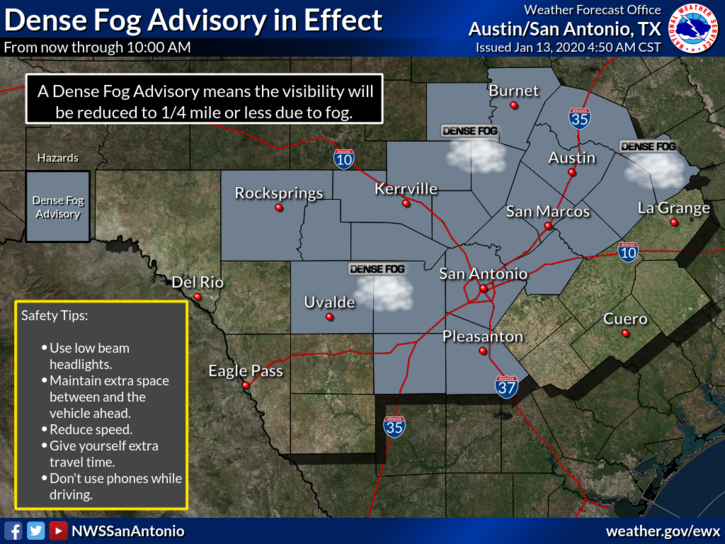
⚠️ NWS has issued a Dense Fog Advisory until 10 AM for Leander and Williamson County. ⚠️
Be safe on the roads - slow down and move over for any emergency vehicles or pedestrians on the side of the road.
#FogSafety#RoadSafety#BeAForce
https://t.co/s9oiVvR1bg
Monday, February 17: A Dense Fog Advisory is in effect until 10 AM CST for much of south central Texas. Dense fog will reduce the visibility to 1/4 mile or less. If driving, slow down, use your low beam headlights, and leave plenty of distance ahead of you.
Due to heavy rain, CR 177 at Brushy Creek has been closed due to high water across the road.
If you see water across any other roads, do not attempt to drive through it! Always #TurnAroundDontDrown! #TADD#FloodSafety
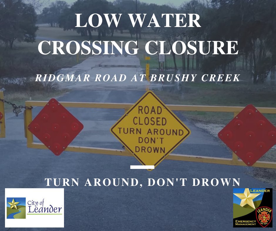
Due to heavy rain, Ridgmar Road at Brushy Creek has been closed due to high water across the road.
If you see water across any other roads, do not attempt to drive through it! Always #TurnAroundDontDrown! #TADD#FloodSafety
🌧💧Over the next few days, we could see 1-3 inches of rain! While only minor impacts are expected, be aware when driving through heavy rain and keep an eye out for high water levels over low water crossings. 💧🌧
🚧🚧🚧Turn Around, Don't Drown!🚧🚧🚧
#PreparingLeander#BeAForce
The next few days are looking stormy!
⛈Today, we have a marginal risk of severe storms. Any stronger storms will be very isolated in nature and only have a low threat of hail. Not all areas in the dark green will see a severe storm. ⛈
#PreparingLeander#EyesToTheSky#BeAForce
The National Weather Service has issued a Dense Fog Advisory for Leander and the Austin Metro until 10 AM.
Slow down during your commute and be careful near schools for children crossing crosswalks. Never use your high beams during fog!
#PreparingLeander#DenseFog#BeAForce
The National Weather Service has issued a Dense Fog Advisory for Leander and the Austin Metro until 10 AM.
Slow down during your commute and be careful near schools for children crossing crosswalks. Never use your high beams during fog!
#PreparingLeander#DenseFog#BeAForce
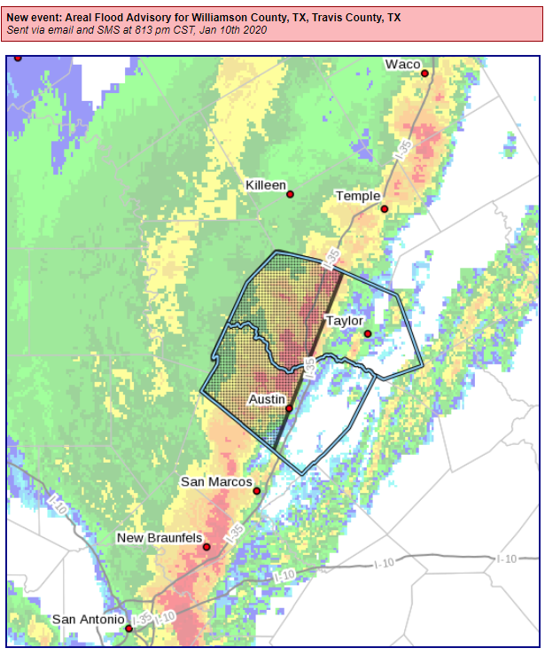
NWS has issued a Flood Advisory for Leander until 11:45 PM for heavy rain due to thunderstorms.
Be careful if out on the roads tonight. Some roads may have ponding water on them. Avoid any low water crossings during the advisory time.