Hello Everyone.
In light of the current situation, I have decided to return (at least temporarily) to reporting about Lebanon.
As some of you may know, I mapped out the war in 2024 (Under the name "Cheetah Intel - Project Cheetah").
Since the conflict between Israel and Hezbollah escalated yesterday, I have been working intensely to map out everything amidst the chaos.
Now I am excited to announce Project Cheetah V2!
Currently, I am actively mapping out:
- Air strikes
- Artillery shelling
- Evacuation warnings
- Ground incursions
And more!
I am putting in as much work as I can, but I am also just a human. While I am giving my absolute best at staying transparent and reliable, I can also make mistakes and map data may be inaccurate, false or baseless.
Especially for air strikes and shelling, data may be inaccurate (as it is an ENORMOUS effort to verify every single strike).
Any dates / times mentioned on the map are in local time.
Please note that work is still in progress and some things are still to be added. Everything is based on OSINT (Publicly available information).
And lastly, if you have any suggestions, just let me know! I am happy to adapt the map to what's best for you to view.
View the map here:
https://t.co/qvIAOoxRuV
Israeli forces launched a new ground attack in the eastern direction of Ghandouriyeh earlier today, coming from Qantara via Wadi Al-Hujeir.
According to Hezbollah statements, confrontations have so far been limited to the eastern outskirts of the town.
Unconfirmed reports also speak of an Israeli attempt to advance towards the Beaufort castle and Arnoun from the direction of Yohmor, claiming that clashes are taking place in the area. Other reports also state that heavy shelling is targeting the area.
However, as said, these reports have so far not been confirmed by any official or independent source. I will update as soon as more information becomes available.
Additionally, Hezbollah confirmed yesterday the Israeli ground attack on Debbine - Marjayoun, stating that they targeted a tank in the area.
The IDF reportedly launched a new ground attack towards Marjayoun and Dibbine.
According to current reports, the IDF sent out a warning to residents of Marjayoun, prohibiting them from crossing the red line (marked on the map).
The area has been shelled over 100 times with artillery and air strikes in the past few hours, and Israeli troops have reportedly reached Jdeidet Marjayoun by now.
Heavy machine gun fire is also reported to be heard in the area.
Please note that this data is currently only based on reports, there is no official or independent confirmation for any of the events happening at this time.
I will update as soon as more information is available.
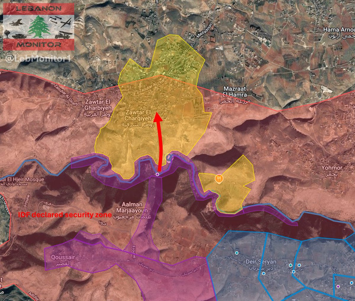
In addition to the ground attack on Zawtar Al-Charqiyeh, the IDF started infiltrating Yohmor (located east of Zawtar Al-Charqiyeh).
High resolution satellite imagery published on X, dated today morning, shows Israeli tanks and armored vehicles reaching as far as the pond of the town.
The IDF continues it's ground attack on Zawtar Al-Charqiyeh, here is what we know as of now:
- Israeli forces are trying to push towards the eastern areas of the town, where clashes are taking place, according to reports.
- Hezbollah stated that they repelled an attempt to advance towards the scout camp.
- In addition to other operations, Hezbollah also stated that they targeted Israeli positions at the cultural complex and at the Zattam farm.
- Sentinel 2 satellite imagery from yesterday (May 26) shows heavily used roads (indicating ground activity) reaching into the Al-Khazzan neighbourhood. Lots of damage across the entire area is also visible.
Apologies for the edit about Haddatha. After following up, I realised that the statement was talking about the Israeli attack on May 19 - Dawn of May 20, not the attack which occured later on May 20.
After advancing towards the Litani river around 2 weeks ago, the IDF launched a ground attack on Zawtar Al-Charqiyeh today. Hezbollah stated that clashes erupted in the morning and are still ongoing as of noon.
The IDF launched another attempt at advancing towards Haddatha today.
Based on currently available information, Israeli forces infiltrated towards the eastern parts of the town:
- According to statements from Hezbollah, clashes took place around the Hussainiya.
- Hezbollah also stated that they targeted Israeli positions at the pond.
- I geolocated an image published by Lebanese media which shows what appears to be a controlled demolition in the eastern part of the town.
IDF ground operations in Southern Lebanon - May 20, 2026
Since the ceasefire began on April 16, the IDF continued operations on the ground, advancing on all axes. Here is what happened since the last map update;
Western Sector:
- Israeli forces infiltrated Chihine and Jebbayn, as well as areas of the Hamoul valley.
- On May 7, the IDF launched a ground attack towards Byout Al-Sayyad, reaching it's outskirts by May 9. Ground activity has not yet been confirmed in the town itself.
Central Sector:
- The IDF reached the majority of Bint Jbeil, with only a few small areas without visible ground activity remaining.
- On May 8, the IDF began an attempt to advance towards Haddatha. According to Hezbollah, they were able to repel the attack. As a result, the Israeli forces retreated back to Rachaf before launching another attack on May 13, where confrontations continue until now. Hezbollah stated that they repelled multiple attempts to advance, including an attack yesterday (May 19), in which the IDF infiltrated via two roads, reaching parts of the southern and eastern neighbourhoods before retreating. Sentinel 2 satellite imagery from May 19 shows ground activity on the southern outskirts of the town.
- Additionally, the IDF entered and reached the majority of Srebbine (located west of Rachaf) around May 14.
(Central) Eastern Sector:
- On May 4, the IDF launched ground maneuvers towards the Litani river south of Zawtar al-Charqiyeh and Yohmor, first reaching parts of the valley around May 9. Following this, an attempt to cross the Litani and advance towards Yohmor's western outskirts was made on May 17. Sentinel 2 satellite imagery from May 19 shows extensive damage in the area, but no clear signs of ground operations.
Additionally, the IDF reached Qussayr (west of Deir Seryan), as well as areas around Deir Mimas.
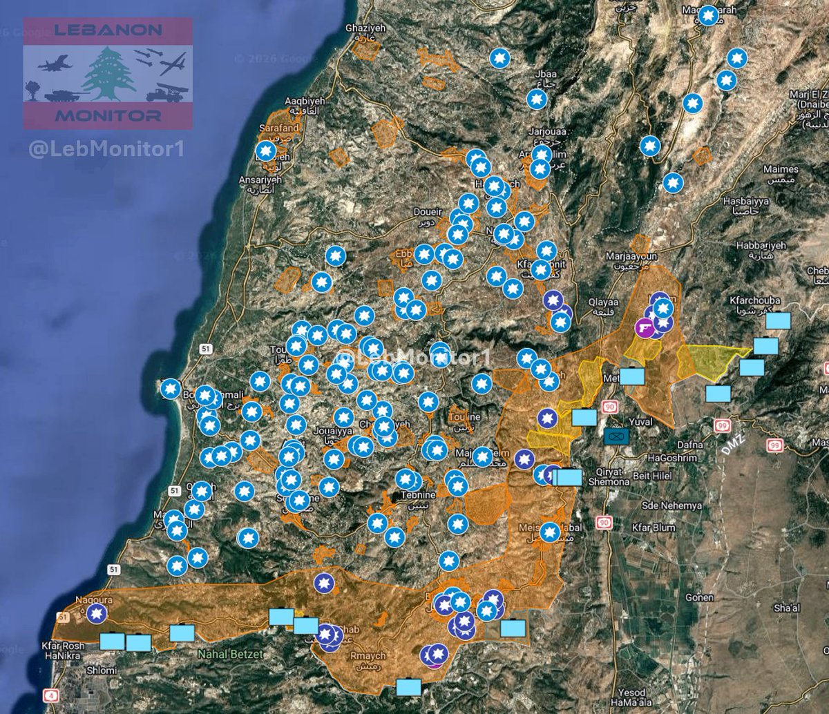
If you want to follow the situation live, make sure to check out my interactive map. I'm giving my best at staying accurate and updating it as much as possible. So far the map includes more than 200 individually documented and assessed areas, as well as 140+ geolocations of imagery and incidents.
Link:
https://t.co/1xJniNUsgS
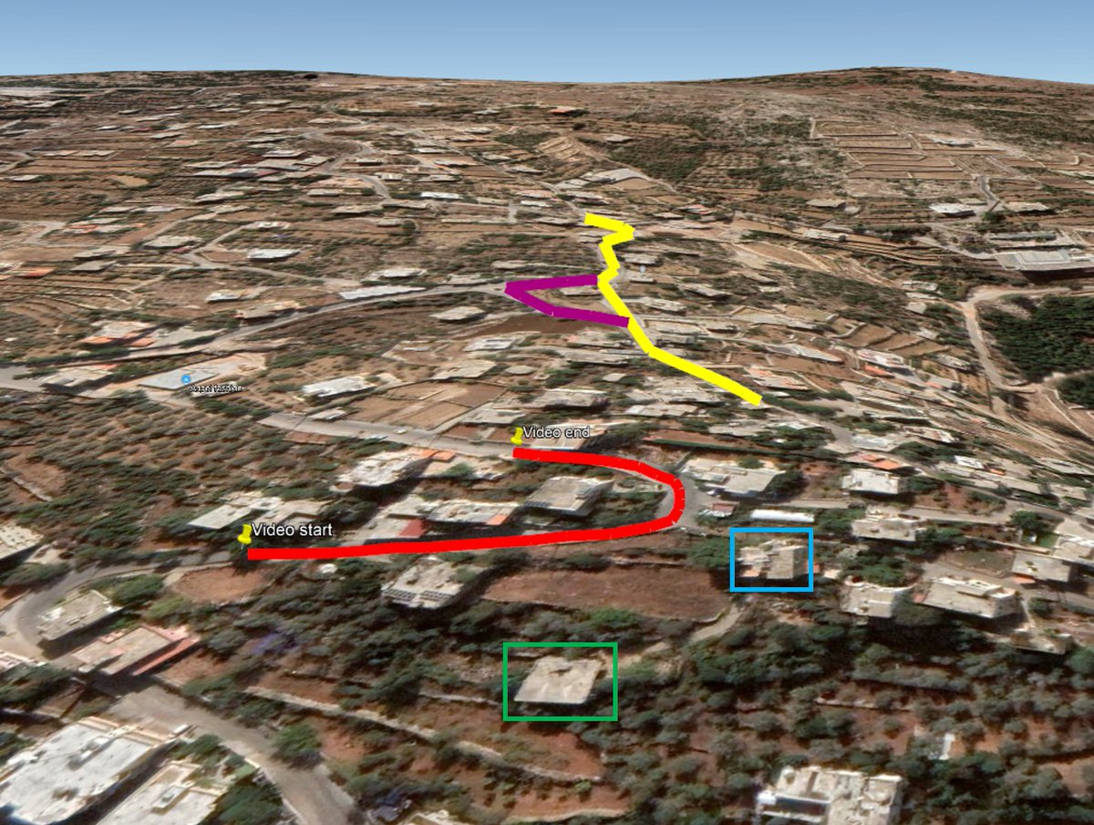
Also, in another video, Israeli vehicles conducting demolition operations in Beit Lif at 33.13541, 35.3326
Video: https://t.co/8bEJdLKhmd
@GeoConfirmed
Monitoring IDF ground operations in southern Lebanon - 24.04.26 update
Since the ceasefire between Israel and Lebanon went into effect, Israeli forces continued their advances on the ground.
Newly released Sentinel 2 satellite imagery (via @SoarAtlas and the copernicus data space ecosystem) confirms new Israeli ground activity in the following areas:
- Bayada
- Chamaa
- Beit Lif
- Rachaf
- Hanine
- At-Tayri
- Bint Jbeil / Ainata
- Maroun Al-Ras
- Mays Al-Jabal
- Houla
- Markaba
- Aadchit (Al-Qusayr)
- Area between Al-Qusayr and Deir Seryan
- Khiam
Additionally, hints of ground activity are visible in Dibbine, where the IDF confirmed to have carried out a raid shortly before the ceasefire. It is likely that the IDF withdrew from the area again, as it lies outside of the yellow line.
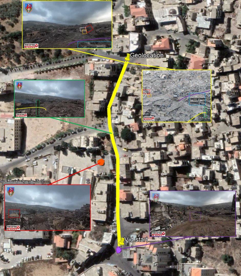
In Bint Jbeil, Israeli forces seem to have reached a majority of the city. However, Hezbollah still appears to be present in some areas, as clashes erupted yesterday (April 24) around the center of the city (Geolocated by @Me1Ray / https://t.co/JoRMEX2G8k).
Also, for the record, I managed to geolocate some footage from Bint Jbeil and Beit Lif:
Bint Jbeil:
Israeli tank photographed. Location of the picture is visible on another video (0:40), on which, at 0:18, we can see part of a mosque, and at the start of the video we can see the roundabout.
Pic: https://t.co/TbjyxaNZfY
Video: https://t.co/clGpJVmWit
Location: 33.11802, 35.43577
Beit Lif:
Israeli vehicle driving along a road at 33.1337, 35.3359
Video (2:30 - 2:58):
https://t.co/hYHPx2RhFj
@GeoConfirmed
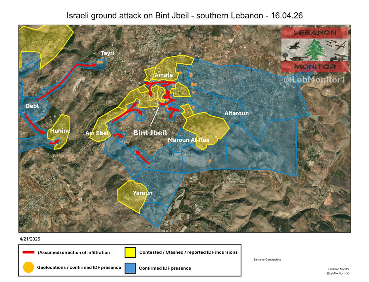
Israeli ground operations in southern Lebanon: Bint Jbeil - 16.04.26 (pre ceasefire)
Between April 10 and April 16, Israeli forces continued their siege and attack on Bint Jbeil.
After assessing various reports, geolocations, and Sentinel 2 satellite imagery, this is the final snapshot of Bint Jbeil before the ceasefire:
- New IDF ground activity is visible in neighbourhoods on the northern and eastern parts of the city, as well as on the western and southwestern outskirts (around Ain Ebel).
- Additional ground activity from the direction of Debl towards Hanine.
- Israeli forces also advanced towards Tayri, a town northwest of Bint Jbeil.
- On Sentinel 2 satellite imagery, enormous damage is visible throughout the area.
While satellite imagery shows massive destruction in the area, this does not directly confirm ground activity or control. In this case, the confirmation methods for ground activity used in the map are newly paved roads or newly dug up soil visible in the area, as well as geolocated evidence.
Apologies for not posting recently, had some technical issues. I'm back now, currently following up on everything and working on map updates. Stay tuned!
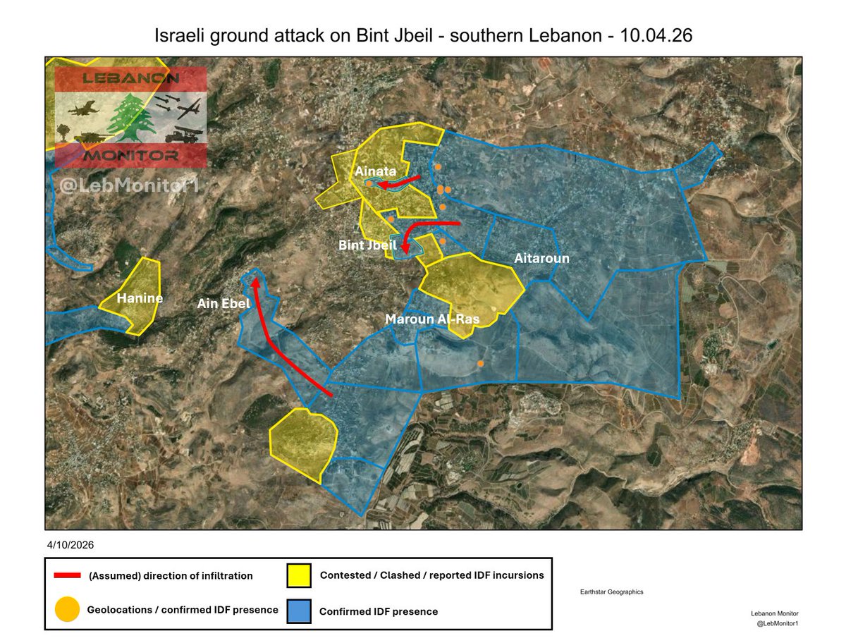
Israeli attack on Bint Jbeil update - 10.04.2026:
According to statements released by Hezbollah, Israeli forces reached the vicinity of Al-Ishraq school (located in Ainata / north of Bint Jbeil), where they were targeted with missiles.
Additionally, after assessing sentinel 2 satellite imagery from April 9 (via @SoarAtlas and the copernicus data space ecosystem), ground activity is visible from the direction of Yaroun towards the eastern outskirts of Ain Ebel, which further confirms attempts to besiege the city.
Ground activity is also visible in a small area of the eastern part of Bint Jbeil.
The IDF has begun a ground attack on Bint Jbeil, one of the major border area cities in Southern Lebanon.
Following an attack towards Ainatha (located northeast of the city) and the eastern outskirts of Bint Jbeil, which started on March 29, the IDF reportedly started besieging the city from multiple directions and has now launched an attack from the eastern direction towards the Bint Jbeil market area, where clashes between the IDF and Hezbollah are currently taking place.
On the map below, I marked the current reported direction of infiltration, as well as possible directions of besiegement.
Please note that due to the lack of available information, it is currently unknown from where exactly and to what extent the city has been besieged.
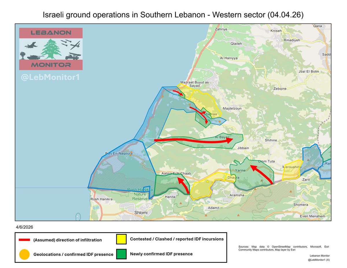
Israeli ground operations in southern Lebanon - Map update and a detailed analysis (04.04.26):
After carefully assessing newly released sentinel 2 satellite imagery from April 4 (via @SoarAtlas and the copernicus data space ecosystem), new geolocations, and various reports with @Stinky915846091, here are our results.
General overview / Summary (detailed analysis and infographics are in the thread):
Western sector:
- New ground activity in Tayr Harfa, the southern outskirts of Aalma Ash-Shaab, Bayada, the southern outskirts of Chamaa, and Yarine.
Central sector:
- New ground activity in Beit Lif's southern and eastern outskirts, Aitaroun, Maroun Al-Ras, eastern Ainata, the area between Yaroun - Maroun Al-Ras, and likely Hanine.
(Central east) / Eastern sector:
- New ground activity in the eastern part of Qantara and in western Khiam.
Detailed analysis and infographics are in a thread below🧵