There are still seats available for Disaster Preparedness and Survival: A guide for individuals, families and communities! To learn how to keep you and your family safe before, during, and after a disaster register with the link below.
(1/2)
Did you know that floods are the most common and costliest natural disaster in the United States?
Did you know that standard homeowners and renters’ insurance generally do not cover flood damage?
(1/5)
Please remember that where it can rain, it can flood. While we at DES deal in emergency management and emergency preparedness every day, we need you to prepare yourselves, as well, to recover from a disaster.
(4/5)
Following the passage of the cold front, temperatures will turn cooler 🥶 and winds 🌬️ will pick up for Saturday.
Please ensure you have multiple ways of receiving severe weather alerts. 📲📺📻
(2/2)
Strong to severe storms (level 2 of 5) ⛈️ are expected to pass through the region tomorrow Friday October 16th, during the afternoon & evening, with the passage of a cold front. Damaging winds🌬️ will be the primary hazard, although a tornado 🌪️ cannot be ruled out, as well.
(1/2)
All are welcome to attend and hear her account of that day and the days that followed.
Date: October 12th, 2026
Time: 10am-12pm or 1pm to 3pm
Click here to register: https://t.co/ZuiNoxMKqB
(2/2)
On October 12, 2026, DES will be hosting two presentations from Norina Bentzel, who was principal at North Hopewell-Winterstown Elementary School on February 2nd, 2001, when an armed attacker entered her building. She will discuss the incident and its subsequent aftermath.
(1/2)
A Heat Advisory is in effect, as heat index values are expected to approach 100°F today🥵, providing plenty of fuel for thunderstorms.
As always, please ensure you have multiple ways of receiving severe weather alerts📲📺📻!
(2/2)
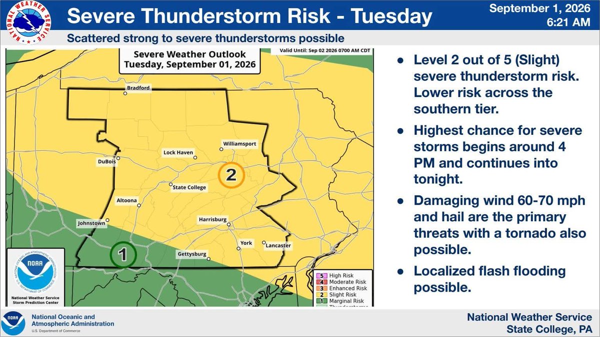
Keep your eyes👀 on the sky today as severe storms⛈️ (level 2 of 5) are expected to impact the region. All hazards are on the table, with damaging winds🌬️ being the primary hazard, with hail☄️ and a tornado🌪️ or two also possible.
(1/2)
These storms will be fueled by high heat and humidity, as the heat index should approach 100°F each day🥵. If you have outdoor activities planned, please drink plenty of fluids to stay hydrated and have multiple ways of receiving severe weather alerts📲📺📻!
(2/2)
Today, September 1st, through Thursday, September 3rd, multiple rounds of severe storms⛈️ and flooding downpours🌊 are possible during the day and overnight. Damaging winds🌬️ will be the primary hazard each day, though hail☄️ and tornadoes🌪️ can’t be ruled out.
(1/2)
Storms will be capable of producing very heavy rain. Urban areas and locations that see multiple rounds of rain will be most susceptible to flooding. Large hail and tornadoes cannot be ruled out.
Please ensure you have multiple ways of receiving severe weather alerts!
(2/2)
A Flood Watch is in effect from 12pm today, August 27th, until 2am tomorrow morning, as severe storms (level 2 of 5) are expected to develop this afternoon and evening. Damaging winds will be the primary hazard across the region.
(1/2)
Severe thunderstorms (lvl 2 of 5)⛈️ are expected to impact the region tomorrow, August 27th, in the afternoon & evening. The primary hazards for these storms are damaging winds🌬️ & flash flooding (lvl 2 of 4)🌊 in urban areas & areas that receive multiple rounds of storms.
(1/2)
The American Red Cross is hosting a Blood Drive🩸 at DES this Friday, August 21st, 2026, from 11:30am to 4:30pm. Every donation can make a difference for someone in need. Click the link below to register today and reserve your spot!
https://t.co/B4CPNQEfcK