🚨Update: That pesky nor’easter that's been lingering out in the Atlantic Ocean for the past few days has strengthened into a subtropical storm named Josephine. But it's still too far away to cause any major problems in NJ. #njwx
https://t.co/ss6SlCnWyQ
🧐 If you are an early riser, don't forget to look for the Orionid meteor shower. Best viewing times will be between 2:30 a.m. and 6:45 a.m. Thursday, after the moon sets and before the sun comes up. #nj#njwx#astronomy
https://t.co/05YZA3cVqG
🚘 🦌 A reminder for drivers in NJ: Deer dating season is in full swing, so more bucks and does are darting out into local roads & highways. More details in the link below from my colleague Lia Opperman @oppermanlia. #nj#deer 🦌
https://t.co/Y3zqQDaOxn
⛈️ The sky over the Pennsylvania Turnpike turned pitch black when storm clouds were moving in at about 6:10 pm Friday as I was driving from NJ to Lancaster. I drove through a few downpours with gusty winds. ⛈️ 🚙 #pawx#njwx
⛈️ More details about the severe thunderstorm watch that's now in effect for all 21 counties in NJ, along with the NYC metro area. (See link below) ⛈️ #nj#njwx#nywx
https://t.co/nzfoSR3GfG
🥶 While everyone's attention is focused on the potentially strong thunderstorms that we might see later today, don't forget about the cold temps coming this weekend. 🥶 #njwx
https://t.co/sMMtqgCSEt
⛈️ Here's what we can expect later this afternoon and this evening in the NJ region. And after the thunderstorms move through, temperatures will be plunging and winds will remain gusty. 🍃 #njwx#nywx#pawx
We've got a bit of a wild weather ride ahead of us, with much warmer air moving in by this afternoon, a stormy evening, then windy and colder weather with a chance of frost in much of the area by tomorrow night.
⛈️ Weather forecasters are growing more concerned about the threat of severe thunderstorms for NJ, eastern PA and the NYC metro area on Friday. #njwx#nywx#pawx
https://t.co/gsS1smwMSH
😲 Our up-and-down weather pattern in NJ continues. After summer-like warmth today (some towns hit the upper 80s), we could get some strong thunderstorms and gusty winds on Friday, then a widespread frost this weekend. #njwx
https://t.co/tzdYSUdAQ9
🥵 ➡️ 🥶 NJ will be getting a taste of summer weather followed by a taste of early winter, all within several days as temps rise into the low to mid-80s on Wednesday before dropping to the 50s on Saturday & into the 30s Saturday night. #nj#njwx
https://t.co/sMmzjwPIBO
❄️ New Jersey had a blockbuster winter last year, with lots of cold snaps and more snow than normal. This winter will likely be different, according to forecasters from @accuweather. #nj#njwx
https://t.co/0tppuKoMtU
😎 Temperatures in the NJ region on Wednesday will feel more like late summer than the middle of fall, running about 15 degrees warmer than normal for Oct. 14. We could see some daily record highs matched or broken, especially down in the AC area. #nj#njwx
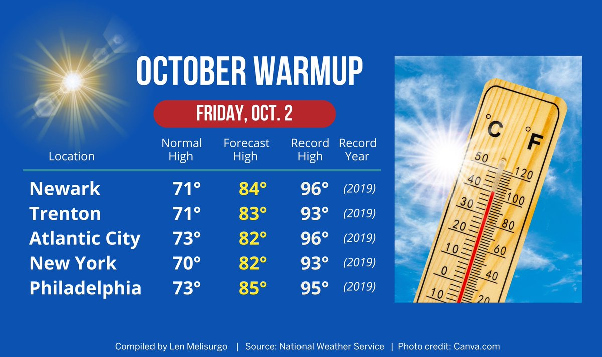
🎃 October has arrived, but it's feeling more like summer than autumn. Highs in the NJ region today will be rising into the upper 70s. On Friday, many areas will see a bigger warmup, with temps running 10° to 12° warmer than average for early October. #nj#njwx
🙁 Serious flooding in Stone Harbor, as per @Zeke_O. Keep in mind, we still have to get through another high tide cycle tonight and Sunday morning. 🙁 #njwx
🍃 Top wind gusts reported in NJ as of early Saturday morning (data from @NWS_MountHolly):
🟣 74 mph - Surf City
🟣 70 mph - Island Beach State Park
🟣 69 mph - Harvey Cedars
🟣 67 mph - Ship Bottom #njwx
🍃 More wind gusts can be found here:
https://t.co/uU09eI6xlp
💡 The big nor'easter has already caused more than 28,000 power outages in NJ. Here's the breakdown as of 8:40 am:
🔴 17,560 - JCP&L
🔴 5,828 - AC Electric
🔴 3,956 - PSE&G
🔴 1,010 - Orange & Rockland #njwx
https://t.co/BeYw3VDF3A