British Institute for Libyan & Northern African Studies (BILNAS) is a membership body sponsored by @BritishAcademy_ We support scholars in Libya and the region
📣 Last week's BILNAS lecture ‘The Right to the City: Strategies for Elite Neighbourhood Development over the Long Antiquity’ by J. Andrew Dufton, is now available to stream (with a full transcript) on the BILNAS YouTube channel.
Click on the link 👇
🔗 https://t.co/dPN96HjQSQ
🐯 Libyan zoo welcomes its first white tiger cub
Tripoli zoo welcomes the birth of its first-ever white tiger cub. The newborn was abandoned by its mother and has been put in an incubator for special care.
The glorious and immense Roman Empire
Leptis Magna, Libya. One of the best preserved Roman cities in the world.
It was built up by Septimius Severus, the first Roman emperor born in Africa. He turned this port town into a second Rome.
After the empire declined it was abandoned and buried under sand for about 1000 years.
These ruins are 2000 years old and you can still walk the original road, sit in the theatre, see the baths where water still collects after rain.
🇱🇾 Ghadames, Libya's 3,000-Year-Old Desert City | Graatje Weber
Once a crossroads of the Garamantes, Roman and Byzantine civilizations, Ghadames later came under Islamic and Ottoman rule. It was an important hub on the ancient trans-Saharan trade routes.
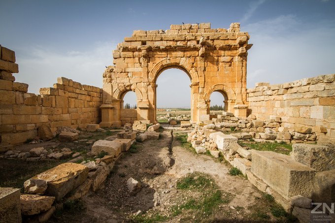
Diana Veteranorum, today called Ain Zana, was an ancient Numido-roman city in Algeria. It was founded in the connection with the settling of veterans of the Legio III Augusta, the only legion in Africa, under the emperor Trajan 98-117 AD.
#Algeria#Numidia#Archaeology
This BILNAS lecture "Troubling Memories and Forgotten Futures: A Jewish Childhood in the Muslim Mediterranean (2023)" by Rebekah Vince, is now available to stream (with a full transcript) on the BILNAS YouTube channel.
Follow this link: https://t.co/sXxiLWVyI1
📣 Less than a week to go until the next BILNAS Lecture:
'Troubling Memories and Forgotten Futures: A Jewish Childhood in the Muslim Mediterranean (2023)' by Rebekah Vince.
📆 Thurs 19 Feb, 5pm (online via Zoom)
Click here to register: https://t.co/DoYSaI8FJR
All welcome.
🗄 The BILNAS Archive was pleased to welcome Libyan researcher Khalifa Bashbash for a research visit last week.
Khalifa is doing research into the many local Libyans who worked with Olwen Brogan at Ghirza and other sites.
Other than the obnoxious cult of personality & pointless AI slop, the museum does offer some interesting insights into Libyan military history like this rare tactical map of late January 1978 of the LAAF offensive on Objective: Ounianga Kebir lakes by the 69th infantry brigade.
Declassified CIA-created map of Libya (1974)
"A Cold War-era strategic overview of Libya’s geography, regional structure, and transportation network during the early Gaddafi era."
Declassified 1974 Libya Map Created By The CIA
This 1974 CIA map of Libya is a political-administrative map showing the country’s provincial divisions, transportation routes, population centers, and the geographic structure of Libya shortly after the rise of Muammar Gaddafi.
The map emphasizes how much of Libya is sparsely populated desert. Most major cities and infrastructure are concentrated along the Mediterranean coast, including:
Tripoli,
Benghazi,
Misrata,
and coastal transport corridors.
Large interior regions show few roads and settlements, reflecting the harsh Sahara environment.
The legend highlights:
roads and tracks,
administrative boundaries,
ports,
airports,
and populated places.
This was strategically important because Libya’s geography strongly shaped both politics and economics.
Oil fields discovered in the 1950s transformed Libya into one of Africa’s major petroleum exporters, even though much of the population remained concentrated near the coast.
By 1974 Libya had recently undergone the 1969 coup in which Gaddafi overthrew King Idris. During the Cold War, the CIA and U.S. intelligence closely monitored Libya because:
of its growing oil wealth,
anti-Western politics,
military expansion,
and increasing Soviet connections.
The map reflects a transitional period:
Libya was modernizing rapidly due to oil revenues, while still lacking dense infrastructure outside coastal areas.
In essence, this map is a Cold War-era strategic overview of Libya’s geography, regional structure, and transportation network during the early Gaddafi era.
More Declassified 1970s CIA Maps: https://t.co/VU22jc7a8U
Book Club: Mohammed Alnaas's award-winning Libyan novel explores masculinity, tenderness and the cost of conforming to society's expectations of manhood.
https://t.co/CVj326yK1y
Hellenistic and Roman-era portraits of Libyans from the "Sanctuary of Cyrene". These were most likely high-status and wealthy Libyans who were integrated into Cyrenean society. It shows that foreign origins and customs did not prevent social integration (from Hodos 2006)
JIM 17/4 is out! Ibadi Manuscripts in Libya: Ibāḍī Manuscript Samples Documented by Ennami; Libyan Heritage in the Sormani Library (Milan) and the Archive of the Lincei (Rome); the Libraries of Nafusa Project; the Library of al-Mzābī; an Omani in Nafusa.
https://t.co/DBcMiKqG2m