🌨️ Heaviest snow tonight will be from 8 p.m. to midnight with accumulations up to 6 inches. Some areas will see rain turning to snow.
RIDOT’s crews are coming in to pre-treat and then get ready to plow. Tomorrow – be aware that temperatures will drop dramatically reaching single digits at night.
Icy roads or patches are possible. Please drive carefully and don’t crowd the plows!
A cold weather burst is headed our way, bringing temperatures below 20 degrees over the next few days. 🌬️ This is a significant drop, so now is the time to prepare and stay safe.
Here are a few tips to keep in mind:
❄️ Bundle Up: Wear layers, hats, gloves, and scarves when heading outdoors.
❄️ Stay Indoors: Limit your time outside, especially during the coldest parts of the day.
❄️ Protect Your Pipes: Let faucets drip to prevent freezing and insulate exposed pipes.
❄️ Check on Neighbors: Look out for the elderly or those in need.
❄️ Pet Safety: Keep your furry friends indoors and away from the cold.
***NOTIFICATION***Road conditions are poor. Multiple vehicles off of the road in area of Breakneck Hill from 146 to Great Rd. Also reports of vehicles off of the road in area of Jenckes Hill and Wilbur. Please be aware of emergency vehicles in the area. Stay safe!
❄️🎶It's timeeee🎶❄️
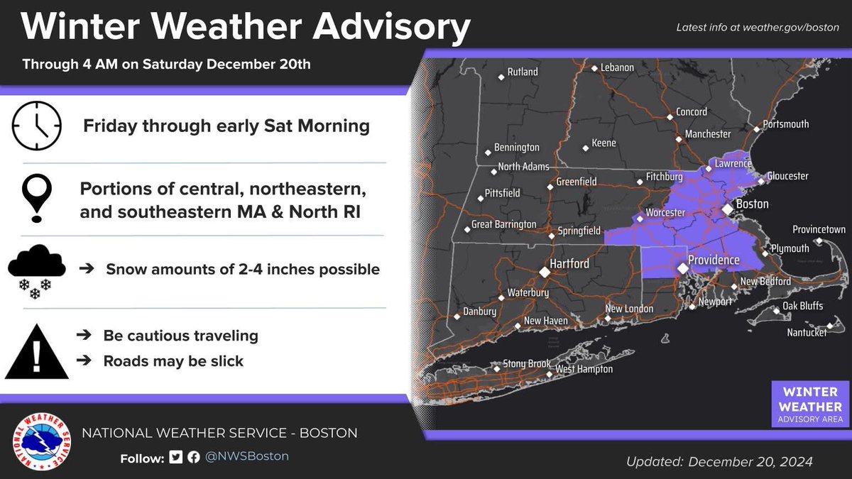
The US National Weather Service Boston MA has issued a ‼️Winter Weather Advisory‼️ for areas in Rhode Island from 12/20/24 10:00AM to 12/21/24 4:00AM.
Snowfall accumulations of 2 to 4 inches. Use caution while traveling.
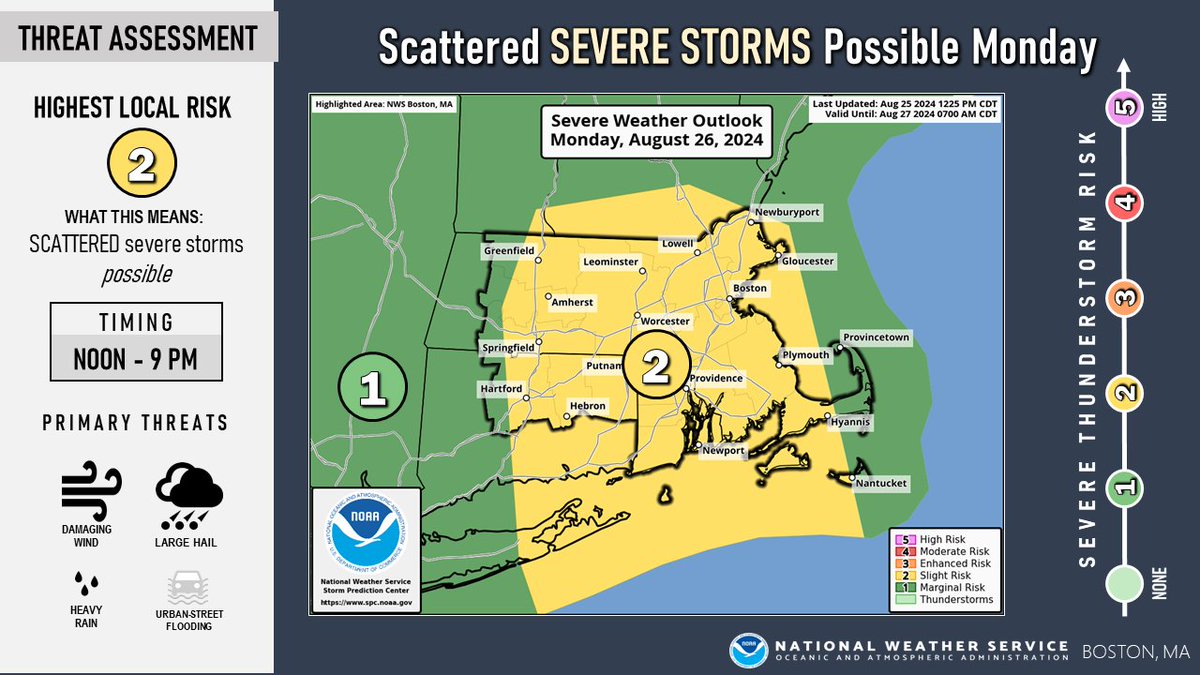
Scattered strong to severe thunderstorms possible across much of southern New England Monday afternoon into the evening (risk greatest Noon to 9 PM). Main threats are damaging winds, large hail, & heavy downpours which may lead to localized flooding. #mawx#ctwx#riwx
[Heat & Isolated Severe Weather Threat] Heat Advisories have been extended into Wed and also expanded to cover the rest of eastern MA including Boston. There also is an isolated severe/very localized flood risk between 2 & 10 pm this evening with the greatest risk north of I-90.
It will be quite warm today and Tuesday, with a heat index between 95°F and 100°F, prompting a Heat Advisory for parts of southern New England. Drink plenty of fluids, stay in air-conditioned rooms, avoid the sun, and check on relatives and neighbors. #MAwx#CTwx#RIwx
Severe Thunderstorm Warning for Providence, Bristol, Kent, Newport, Bristol, Washington until Jun 30 4:15PM. A severe t'storm is happening or imminent. Stay indoors and away from windows until the storm passes.
Update: Lincoln Incident. Red Cross will be staging in town throughout the morning. Contact 1-800-RED-CROSS (733-2767) for assistance with placement if necessary.
Storm Path through Lincoln:
Angel Road/Twin River/ BreakneckHill/ Dexter Rock/ River Road.
If you have lost power, report it to RI Energy at 1-855-743-1102. If there are downed or arcing wires in your neighborhood please stay away and dial 9-1-1.
Town of Lincoln Large Wind event 11:20PM. Heavy damage throughout town. Trees, electrical wires, phone wires and more down. RI energy, RIEMA, NWS, and RedCross in the area assisting with assessment.
[Dangerous Heat & Humidity] After a beautiful weekend, dangerous heat & humidity begins to overspread parts of the region Tue & peaks in the Wed through Fri time frame. Outside of any relief on the immediate coast from sea breezes...expect heat indices between 95 and 105 degrees.
[Dangerous Heat Next Week] Be ready for a long stretch of very hot and humid weather Tue-Fri. Outside of any relief on the immediate coast from sea breezes...expect heat indices between 95 and 105 degrees.
FEMA Disaster Recovery Center
Providence County – DRC #5
CCRI Lincoln Campus
1762 Louisquisset Pike
Lincoln, Rhode Island 02865
Parking available at main parking lot (entrance B): NOW OPEN Monday-Friday 0800-1830;Saturday 0800-1630, Sunday – CLOSED
https://t.co/TeeQh7WsOG
[Updated Storm Briefing] A late season Nor'easter will bring heavy rain/river flooding as well as sleet and snow into Thu. The main winter weather impacts will be in the higher terrain and near the NH border. Strong to damaging winds along with coastal flooding are also expected.
***ROAD CLOSURE*** Smithfield Ave from Woodland St to Grandview Ave. in Lincoln. Please use caution in the area. Consider Walker St. to Chapel St. as an alternate. Also impassable; Smithfield Ave at Reservoir Ave. near Cumberland Farms. First responders in the area.




![NWSBoston's tweet photo. [Heat & Isolated Severe Weather Threat] Heat Advisories have been extended into Wed and also expanded to cover the rest of eastern MA including Boston. There also is an isolated severe/very localized flood risk between 2 & 10 pm this evening with the greatest risk north of I-90. https://t.co/n7Q7AoIieQ](https://pbs.twimg.com/media/GSCJE4ebgAAc6es.jpg)


![NWSBoston's tweet photo. [Dangerous Heat & Humidity] After a beautiful weekend, dangerous heat & humidity begins to overspread parts of the region Tue & peaks in the Wed through Fri time frame. Outside of any relief on the immediate coast from sea breezes...expect heat indices between 95 and 105 degrees. https://t.co/FCOxPpOyQx](https://pbs.twimg.com/media/GQGl5yjacAAn36D.jpg)
![NWSBoston's tweet photo. [Dangerous Heat & Humidity] After a beautiful weekend, dangerous heat & humidity begins to overspread parts of the region Tue & peaks in the Wed through Fri time frame. Outside of any relief on the immediate coast from sea breezes...expect heat indices between 95 and 105 degrees. https://t.co/FCOxPpOyQx](https://pbs.twimg.com/media/GQGlytLbEAAC6C8.jpg)
![NWSBoston's tweet photo. [Updated Storm Briefing] A late season Nor'easter will bring heavy rain/river flooding as well as sleet and snow into Thu. The main winter weather impacts will be in the higher terrain and near the NH border. Strong to damaging winds along with coastal flooding are also expected. https://t.co/jzaCah4OLI](https://pbs.twimg.com/media/GKRCbQXWQAAfVVe.jpg)
![NWSBoston's tweet photo. [Updated Storm Briefing] A late season Nor'easter will bring heavy rain/river flooding as well as sleet and snow into Thu. The main winter weather impacts will be in the higher terrain and near the NH border. Strong to damaging winds along with coastal flooding are also expected. https://t.co/jzaCah4OLI](https://pbs.twimg.com/media/GKRCXbiXEAAKWEn.jpg)
![NWSBoston's tweet photo. [Updated Storm Briefing] A late season Nor'easter will bring heavy rain/river flooding as well as sleet and snow into Thu. The main winter weather impacts will be in the higher terrain and near the NH border. Strong to damaging winds along with coastal flooding are also expected. https://t.co/jzaCah4OLI](https://pbs.twimg.com/media/GKRCUiSWoAAwTWO.jpg)


![NWSBoston's tweet photo. [Heat & Isolated Severe Weather Threat] Heat Advisories have been extended into Wed and also expanded to cover the rest of eastern MA including Boston. There also is an isolated severe/very localized flood risk between 2 & 10 pm this evening with the greatest risk north of I-90. https://t.co/n7Q7AoIieQ](https://pbs.twimg.com/media/GSCJRDfaIAAO9k6.jpg)

![NWSBoston's tweet photo. [Dangerous Heat & Humidity] After a beautiful weekend, dangerous heat & humidity begins to overspread parts of the region Tue & peaks in the Wed through Fri time frame. Outside of any relief on the immediate coast from sea breezes...expect heat indices between 95 and 105 degrees. https://t.co/FCOxPpOyQx](https://pbs.twimg.com/media/GQGmf8ubkAAe3B8.jpg)
![NWSBoston's tweet photo. [Dangerous Heat Next Week] Be ready for a long stretch of very hot and humid weather Tue-Fri. Outside of any relief on the immediate coast from sea breezes...expect heat indices between 95 and 105 degrees. https://t.co/hszFbgOa7B](https://pbs.twimg.com/media/GQI7S01bYAA1w2K.jpg)

![NWSBoston's tweet photo. [Updated Storm Briefing] A late season Nor'easter will bring heavy rain/river flooding as well as sleet and snow into Thu. The main winter weather impacts will be in the higher terrain and near the NH border. Strong to damaging winds along with coastal flooding are also expected. https://t.co/jzaCah4OLI](https://pbs.twimg.com/media/GKRCeZMWoAA0mwg.jpg)


