An interesting/worrying forecast for the South West Indian Ocean, with another tropical cyclone on the way.
ECMWF IFS: growing likelihood of the cyclone making 2nd landfall in MDG.
AI models: storm staying out in Moz channel, or even landfall in MOZ
https://t.co/1Wwio1NuEs
.@CroixRouge PR: priorities of response to 'chaos and fear' #CycloneChido has unleashed on #Mayotte are water, food, hygiene, shelter; UK @UniofReading scientists note Indian Ocean has been 'incredibly' warm, possibly fuelling storm; pic @Interieur_Gouv - https://t.co/vVPGvKEKb3
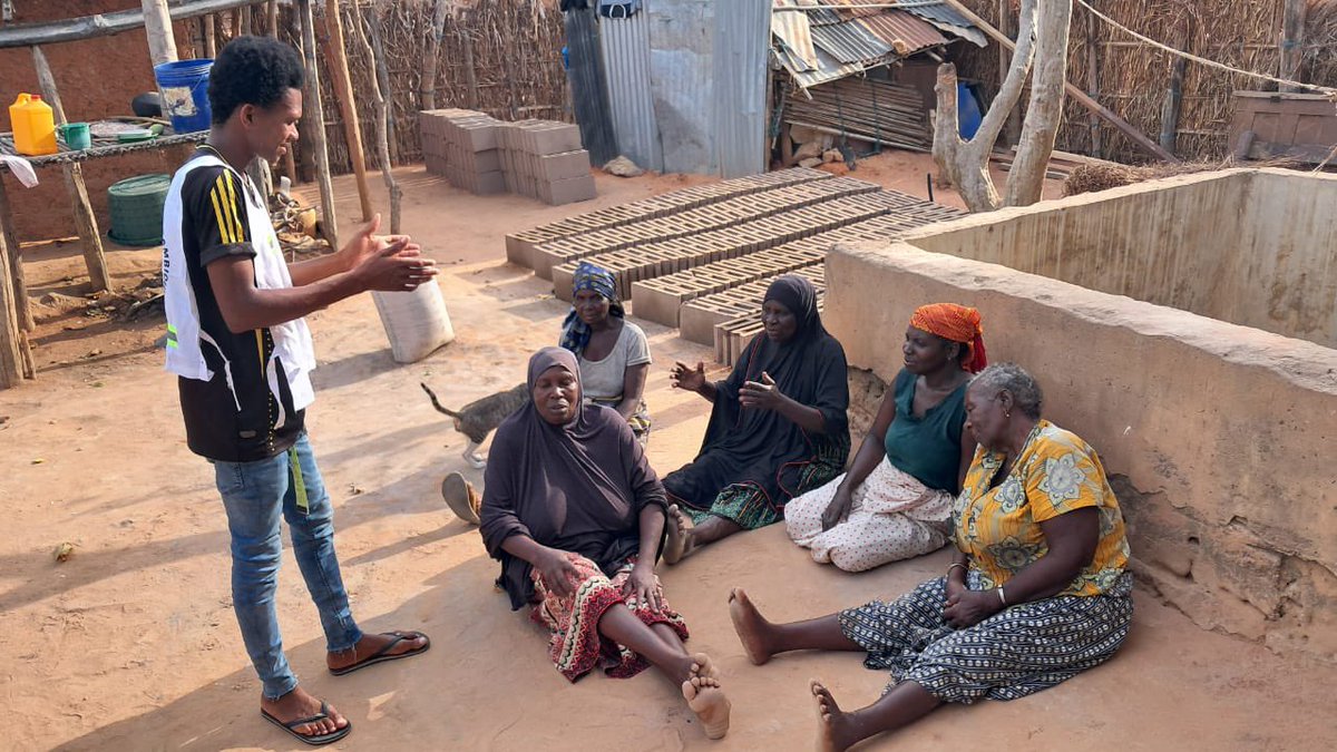
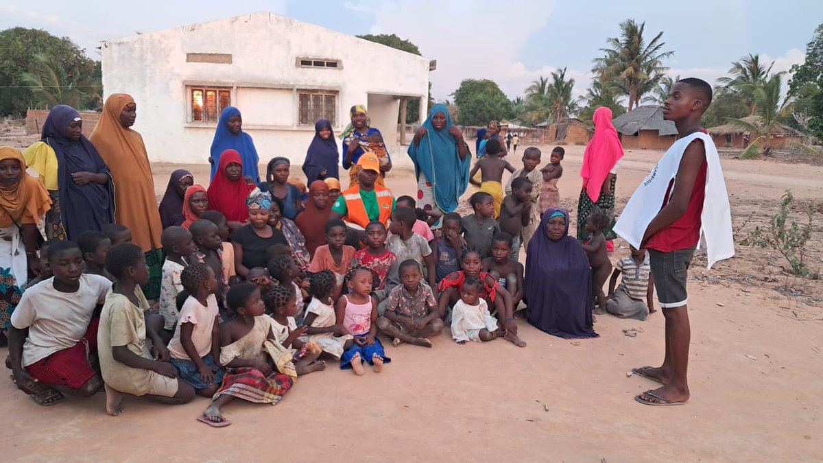
The landfall of #CycloneChido in Mozambique as a Cat4-equivalent storm was well forecasted, providing @Red_Cross_Moz sufficient time to support vulnerable communities with anticipatory actions.
As #CycloneChido made landfall in #Mozambique, increased preparedness by @Red_Cross_Moz proved vital.
Over 2,000 families received life-saving messages ahead of the cyclone, vulnerable families have received emergency supplies, and boats were prepositioned for search & rescue.
Small islands must be supported to build resilience to tropical cyclones. It is not enough to just improve early warning systems. We must strengthen homes and critical infrastructure to ensure that people have somewhere safe to shelter and essential services remain operational.
Small islands are extremely vulnerable to cyclones. The path of Cyclone Chido was well forecasted several days ahead, but communities on small islands like Mayotte can't move out of the path of the storm - there's nowhere to go.
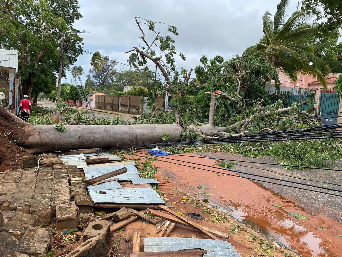
Cyclone #Chido made landfall in Mayotte with devastating wind conditions and heavy rains triggering severe flooding. Extensive damage has been reported across the island, including destroyed infrastructure and widespread power outages.
The situation on the ground is still uncertain, and it is to be feared that the needs are immense. The French Red Cross @CroixRouge, in coordination with its Indian Ocean Regional Intervention Platform @PIROI_CRF, is mobilizing to assist those affected, having activated its emergency plan in anticipation of the cyclone's arrival.
My thoughts are with everyone impacted by this disaster.
The intensity of tropical cyclones in the South West Indian Ocean is increasing. This is consistent with what we expect in a changing climate as warmer oceans fuel more powerful storms.
Watch how #PepitoPH#ManYi is deflected by its landfall on Catanduanes island. If the forecast model gets the track of the cyclone slightly wrong, the deflection looks quite different.
After striking the island of Catanduanes in the #Philippines, Typhoon Pepito / Man-yi is forecast to soon make another landfall over Luzon near Baler with winds of around 185 km/h 🌀 #PepitoPH
Rafael Navarro, veí de Xiva, va gravar des de la finestra de sa casa, la vesprada del 29 d’octubre, com augmentava el cabal de la rambla de Poio durant, aproximadament, quatre hores.
🔴 Segueix el minut a minut: https://t.co/Zm8At8CvLL
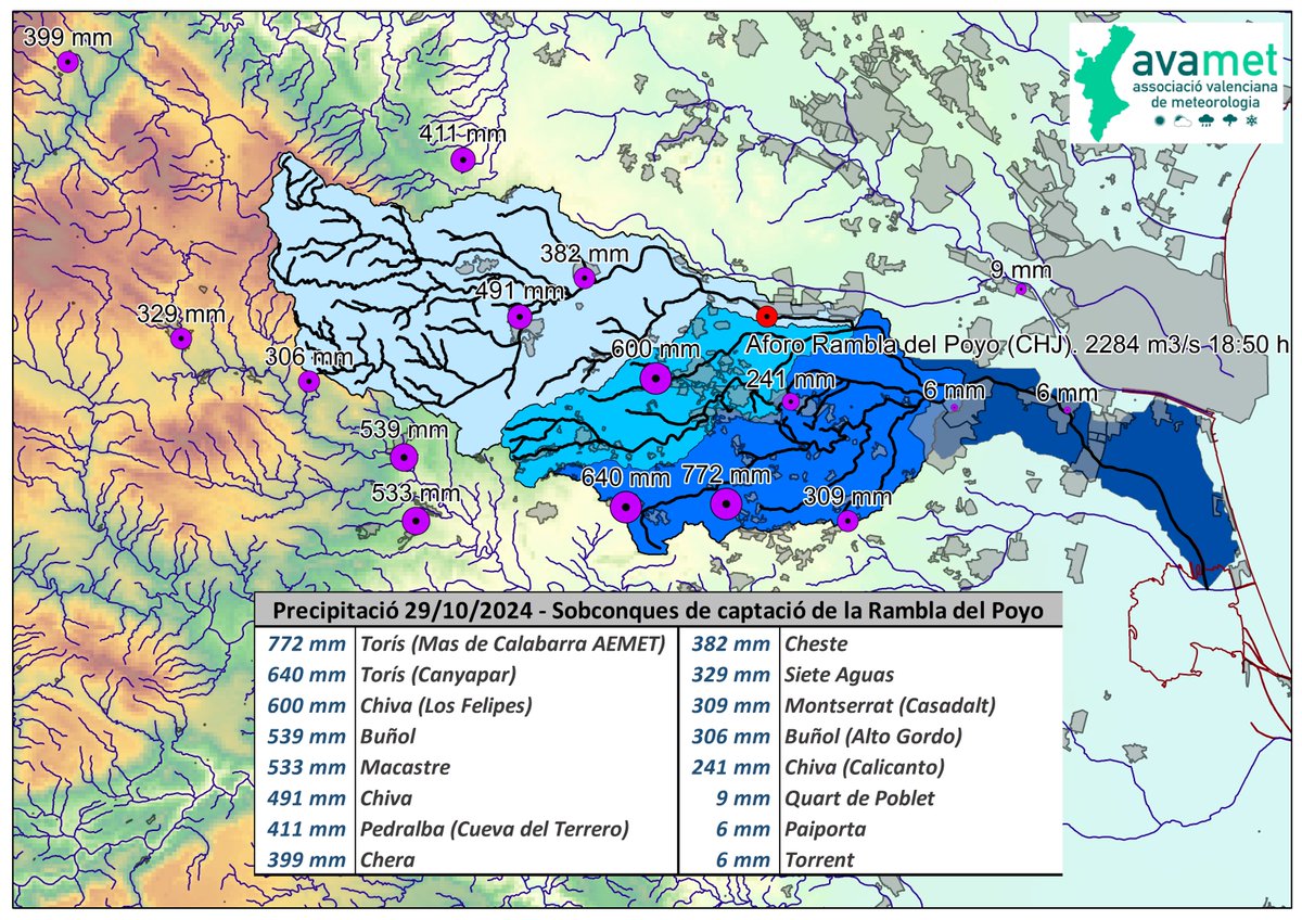
Hem preparat un mapa de la conca de la Rambla del Poyo i les pluges caigudes el 29 d'octubre.
La riuada a l'Horta Sud va tindre un cabal molt superior a eixos 2.284 m3/s que va registrar l'aforament perquè aigües avall la rambla va arreplegar molta més aigua d'altres barrancs.
Great thread (for weather nerds at least) on rainfall observations from Valencia floods last week.
I'd be interested to know how far back the sub-daily measurements go.
DATO OFICIAL | Precipitación acumulada en la estación meteorológica de Turís Mas de Calabarra.
29 de octubre de 2024:
Total diario: 771.8 l/m²
Precipitación máxima en 1 h: 184.6 l/m²
Precipitación máxima en 30’: 102.8 l/m²
Precipitación máxima en 10’: 42.0 l/m²
Duración: 14h 00'
@HayleyJFowler@JamesPope10 I made a mental note to never be surprised what water can do after watching videos of the storm surge during Haiyan / Yolanda:
https://t.co/0S7O9zRIR0
You can see in this video why flash floods are likened to inland tsunamis. Even with a warning it is difficult to get out of the way in time. The danger also comes from the amount of debris carried in the flow. Extreme rainfall can cause these walls of water. #Valencia
Really like this framing from Prof. Ana Camarasa-Belmonte of rainfall events in Eastern Spain becoming less of a resource and more of a risk: https://t.co/wC7vrVPCXk
@PeaseRoland@RCClimate@royalsociety@JoyOmmer And we have just published this paper calling for the scientific community to be more imaginative when it comes to researching unprecedented weather / climate events: https://t.co/cWZipjZqre
@PeaseRoland@RCClimate@royalsociety@JoyOmmer I also really like this approach from scientists at Willis Towers Watson: https://t.co/4eCg9lnXlG
In fact, last week we ran a session in Berlin on how to harness imagination to anticipate unprecedented events, and incorporated some excellent presentations from both Joy & Jess.