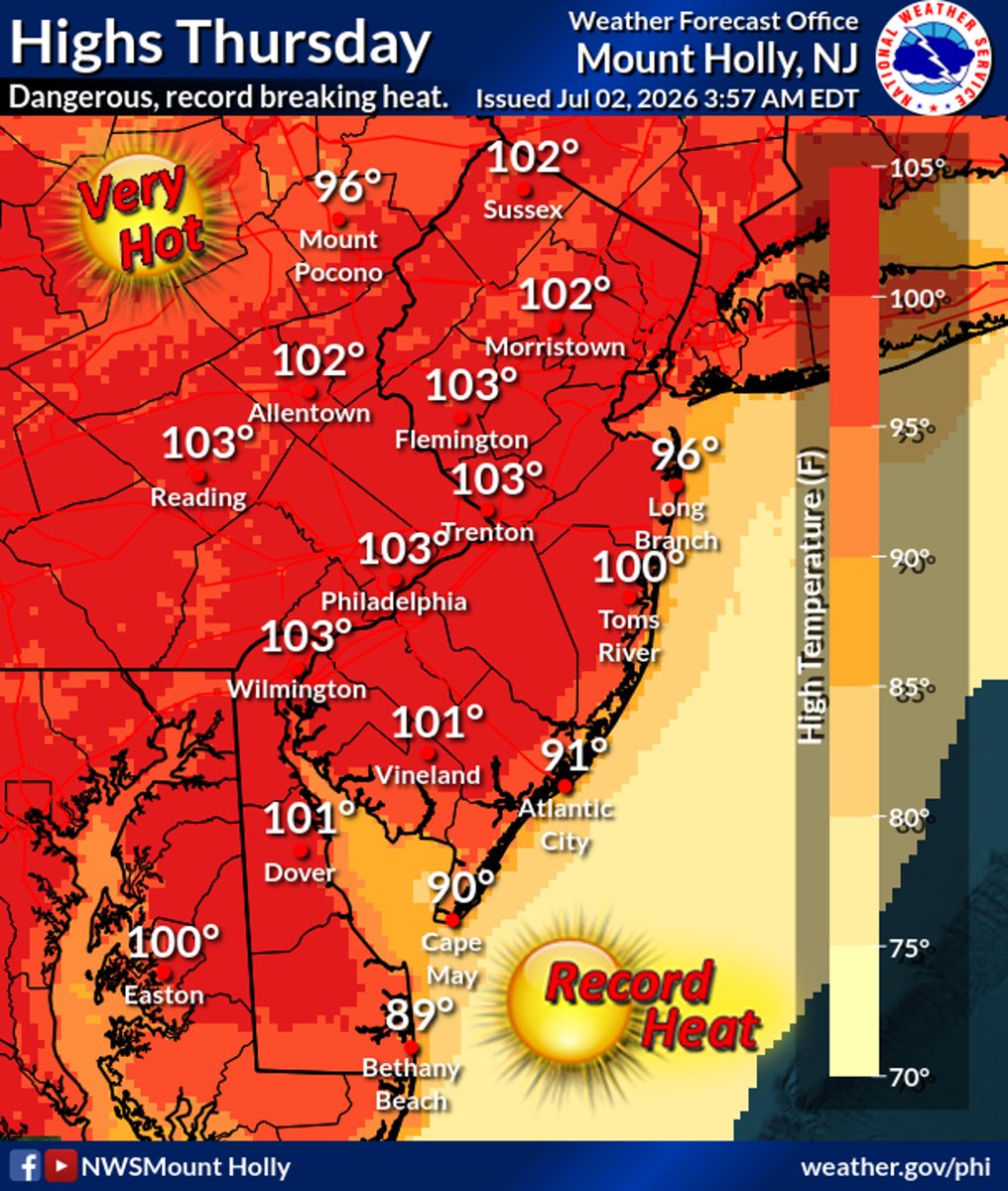
⚠️💯🥵 Triple digit temperatures expected inland today, along with heat indices of 105-115° in most areas. The hottest conditions are expected today through Friday, but dangerous heat will continue through Saturday. (1/2) #PAwx#NJwx#DEwx#MDwx
Concern is growing that dangerous heat will build for mid to late week as a heat dome expands eastward. Model guidance shows highs nearing or exceeding 100 degrees Thursday, and possibly again on Friday. Heat index will be higher. #NJ#NJWX#WX#Weather
Severe thunderstorms, damaging wind, and periods of heavy rain are forecasted for New Jersey later this afternoon and through the evening.
Remain alert, monitor your local weather forecast, and never drive through a flooded area.
⛈️ A few severe storms are possible again later this afternoon and evening. Coverage of storms is anticipated to be lower than Thursday, and not everyone will see storms. Damaging wind gusts are the main threat today. Remain alert for changing conditions! #PAwx#NJwx#DEwx#MDwx
Belleville, Essex County, New Jersey - The May 3, 2026 fire turned into a 12 alarm.
The fire broke out at 347 Cortlandt Street at a Mattress warehouse.
This was not an industrial complex when I grew up here. This area of Belleville was called the Valley. It is 3 blocks up from Route 21 and the Passaic River.
🔥All Belleville Public Schools are closed today, Monday, May 4, due to the fire's ongoing impact on local services.🔥
🔥Town Hall and the Police Department lost power during the incident. Consequently, 911 calls are being handled by Nutley.🔥
Families in the immediate area were evacuated. Nearby towns of North Arlington and Lyndhurst have been advised to keep their windows shut due to the heavy smoke and air quality.
At one point, firefighters ran out of water and tanker trucks had to be brought in by the U.S. Army.
This fire is still raging as of this morning, May 4, 2026.
BREAKING NEWS: Belleville has declared a state of emergency and closed all schools this morning as a massive warehouse fire spread to multiple buildings and force evacuations across the town.
https://t.co/Vybq8QxzDh
#News12NJ#Belleville#BreakingNews
Heads up, New Jersey – the weather may be beautiful right now, but we are expecting thunderstorms this afternoon, and some storms could turn severe.
Please monitor your local forecast and stay safe!
BLIZZARD WARNING: Gov. Mikie Sherrill said New Jersey is prepared for the approaching blizzard as a state of emergency begins at noon.
https://t.co/GzosB29yk9
SURPRISE SNOWFALL FRIDAY NIGHT FROM AN ARCTIC FRONT ❄️
A strong, negatively-tilted upper-level trough will rotate through the region, producing a quick but impactful thump of snow late Friday into early Saturday as ground temperatures will be cold enough to support "stickage". Strong lift along the front should be enough to squeeze out at least a coating for most, with surprise 1–2" totals (locally higher)—especially north and west of NYC and into the suburbs.
Roads could turn slick fast during the overnight hours, so don’t be caught off guard.
This is Part 1 of a two-part winter saga, as a much harsher and more dangerous Arctic air mass pours in behind it, setting up bitter wind chills and brutal cold through the weekend.
@PIX11News
Today, I joined @GovSherrillNJ and legislative leaders for an OEM briefing on the impending snow storm. Our state is coordinating closely as it approaches but please stay off the roads and stay safe! Visit https://t.co/uvK4Mcsn1W for preparedness tips.
8AM STORM UPDATE | SHORT-RANGE MODELS SPLIT ON SLEET CHANGEOVER
**NO Updates until later this morning as I will be driving into the city** I am on TV at 2pm on CHANNEL 11
One of the biggest questions today is how fast (or if) NYC changes from heavy snow to sleet.
The NAM aggressively flips the city to intense sleet this afternoon.
The HRRR? Not buying it — keeps us mainly snow.
That difference alone is the difference between:
➡️ A few more inches of snow
➡️ Or a sleet-fest that compacts totals
Here’s what’s happening:
By late afternoon, strong lift (omega) moves over the city, setting up a major “air battle” about 7,000 feet above ground.
• The NAM drives temperatures at 700mb to +1°C to +2°C — warm enough for sleet
• The HRRR keeps that layer colder — favoring snow
The wildcard: dynamic cooling.
When snowfall rates get intense enough, they can cool the column and fight off warm air intrusion. That effect is often under-modeled — but it only works if snowfall is truly heavy (S+ rates).
If banding locks in, snow may hold longer.
If it doesn’t, sleet wins.
Bottom line:
This is potentially worth an additional 2–3" of snowfall for NYC — or another inch of sleet in addition to what's coming.
Impossible to know exactly how it plays out until it happens — but this is the critical battleground today.
Love a good plot twist. 🎭❄️
@PIX11News