08/06/26 Australian Bureau of Meteorology.
Mapa #Global y #Sudamerica
Anomalía #Precipitaciones respecto al promedio.
- Semana 13 al 19 Junio 2026
- Semana 20 al 26 Junio 2026
(Modelo al 08 Mayo 2026) https://t.co/yLVwbJmIIN
08/06/26 #ElNiño costero #ATSM#Región1+2 #Región3#Calentamiento continuidad reforzamiento
y expansión, asociado al arribo de pulsos
#OndaKelvin positiva
(Pronóstico: 09 al 17 Junio 2026)
Achurado #ATSM +3°C a mayor
Fuente: CEMS - Copernicus
08/06/26 Señal Altimétrica #AnomalíaNivelMar (ANM)
#OndaKelvin positiva alcanzando #Región1+2
y borde sudamericano, reforzando #Calentamiento
(Animación: 16 Marzo al 01 Junio 2026)
(01 Jun 2026 vs 01 Jun 2015 vs 26 May 1997)
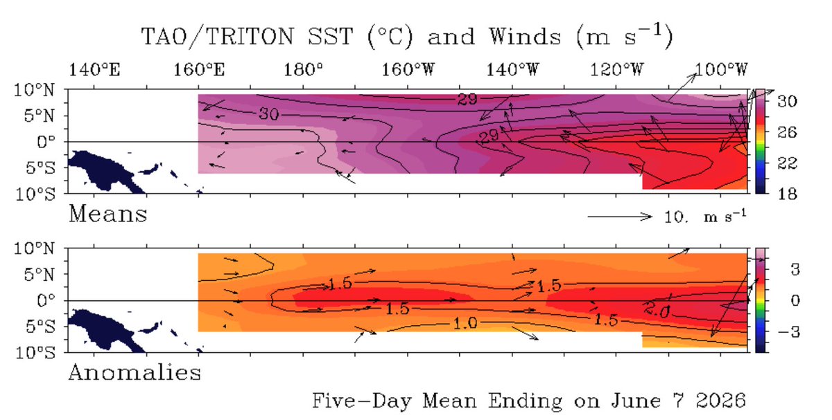
08/06/26 #ATSM Pacífico ecuatorial oriental
(promedio diario)
#Región3#ElNiño Fuerte (+1.6°C)
#Calentamiento continúa incremento en progreso, asociado a surgencia de #OndaKelvin a superficie
y mayor debilitamiento de #Vientos de bajo nivel durante última semana.
08/06/26 Señal Altimétrica Regiones #ElNiño#AnomalíaNivelMar (ANM)
#VolumenAguaCálida (VAC)
Comparativo: 02 Junio 2026 vs 2023
vs 2015 vs 1997
(Fuente: Copernicus Marine Service)
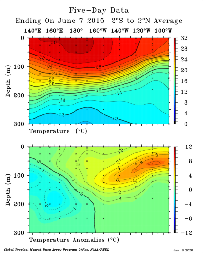
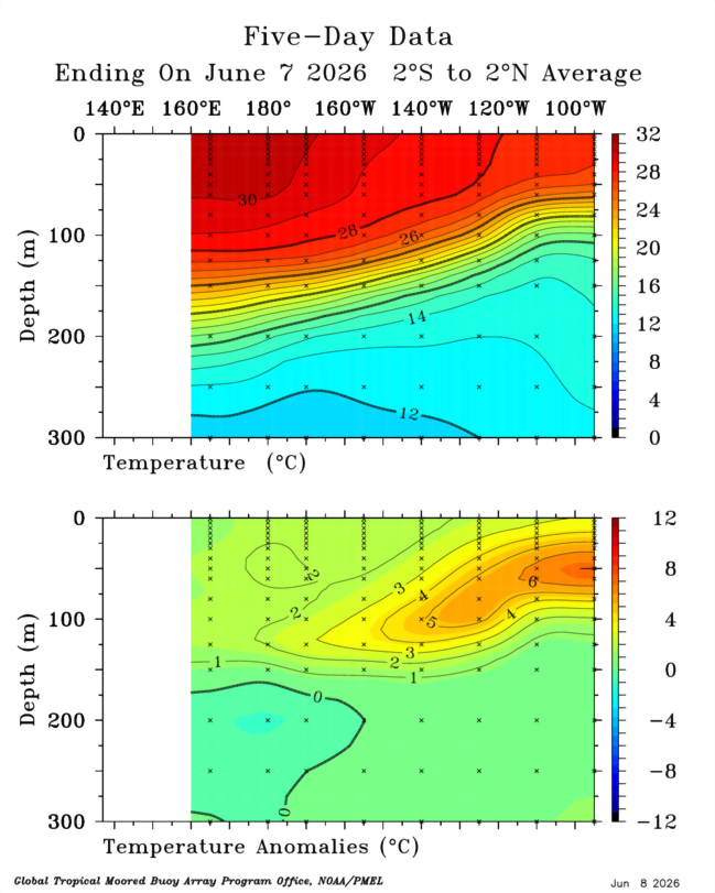
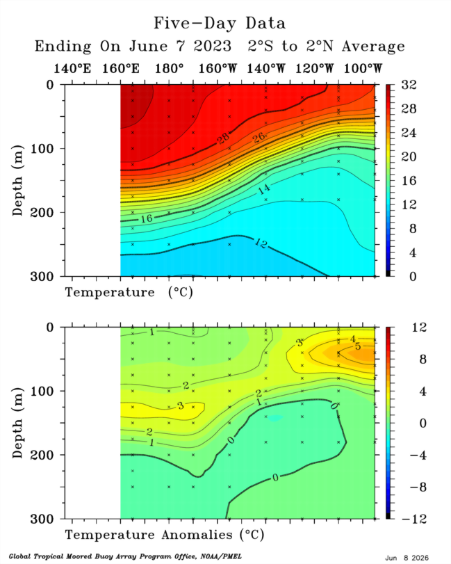
08/06/26 Estructura térmica subsuperficial
en el Pacífico ecuatorial tropical.
Comparativo: Mayo 2026 vs Mayo 1997
vs Mayo 2015 vs Mayo 2023
Además, se ha formado una 4ta #OndaKelvin
y en progreso, que reforzará la #Expansión
e #Intensidad del evento actual.
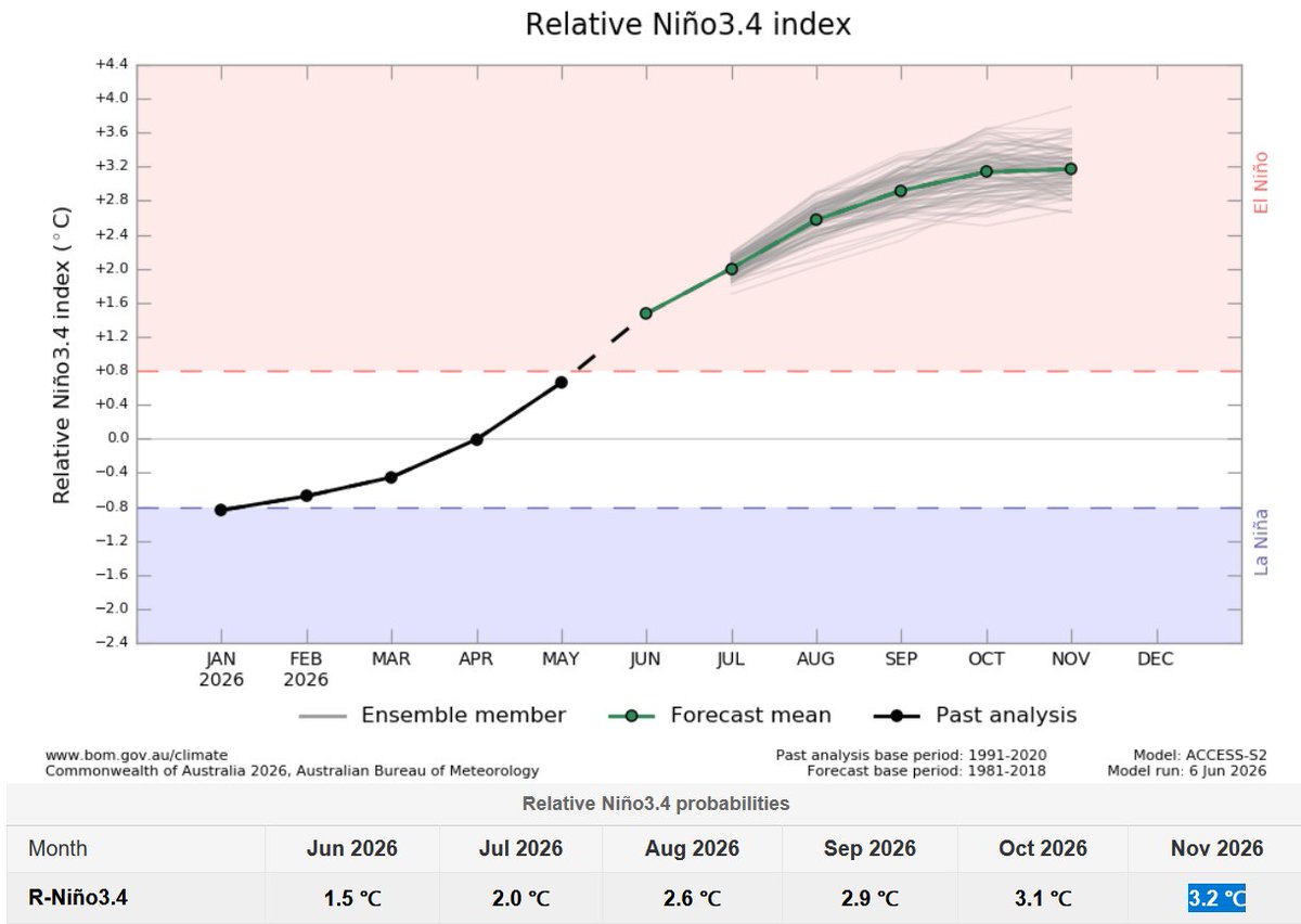
08/06/26 #ATSM#ElNiño BoM (Australia)
- #Región3.4 Moderado hacia Fuerte+
(durante Junio a Noviembre 2026)
- #Región3 Moderado hacia Muy Fuerte++
(durante Junio a Noviembre 2026)
(Actualizado al 06 Junio 2026)
08/06/26 #ATSM BoM (Australia)
Mapas de Regiones #ElNiño
Julio - Agosto - Setiembre 2026
Mayor fortalecimiento mensual
en expansión e intensidad.
(Actualizado al 08 Junio 2026)
08/06/26 #Climate#ENSO#ElNiño Global
(Actualizado a Junio 2026)
Probabilistic forecast similar to NOAA's,
using 643 ensemble members across
13 different models.
Peak Nov +3.0°C Very Strong+
Here are the current results using the
Relative Oceanic Niño Index (#RONI).
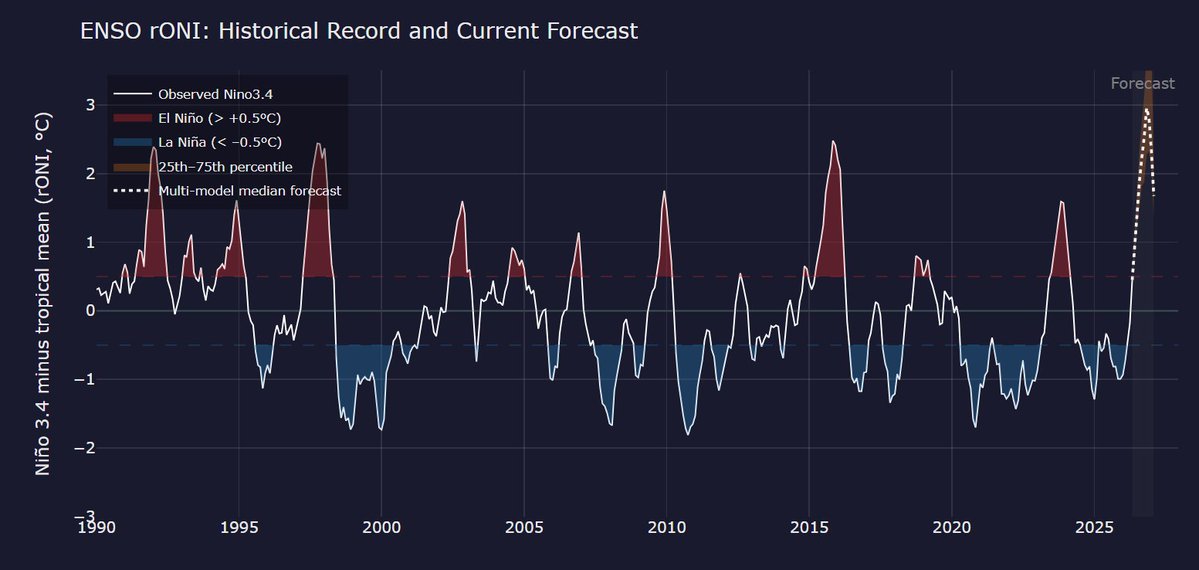
08/06/26 #Climate#ENSO#ElNiño Global
(Actualizado a Junio 2026)
Probabilistic forecast similar to NOAA's,
using 643 ensemble members across
13 different models.
Peak Nov +3.4°C Very Strong++
Here are the current results using the
Oceanic Nino Index (ONI).
When it comes to El Niño, atmospheric changes matter just as much as changes in sea temperatures.
That's because it's a coupled ocean-atmosphere phenomenon.
Looking at velocity potential, which marks areas of rising air (green) and sinking air (brown) in response to warming and cooling tropical seas, a very strong atmospheric El Niño response is forecast during the months ahead — with abundant rising air above the Pacific.
That response is predicted to be similar to or even more intense than past super El Niño events, such as in 2015, 1997 and 1982.
A positive Indian Ocean Dipole is also looking increasingly likely to develop later this year, which would reinforce El Niño's effect by causing yet more sinking air over Indonesia.
However, because warm water is forecast to extend farther west in the Pacific than during the most recent super El Niño events, there may also be more rising air farther west this year. This could influence the weather patterns that this El Niño produces.
The atmospheric response in 2026 is forecast to be much stronger — and markedly different — than in 2023.
These changes in rising and sinking air arise from warm ocean waters shifting from west to east across the tropical Pacific, leading to more thunderstorms in the eastern Pacific and fewer in the west.
This, in turn, influences weather patterns across the globe by altering jet streams and storm tracks, as these thunderstorms release heat into the atmosphere.
Such long-distance links between weather patterns are known as teleconnections.
06/06/26 #NCEP NOAA
Modelo: #CFSv2 (Dic 2026 y Ene 2027)
#NMME (Dic 2026 y Ene 2027)
Mes Inicio: Junio 2026
Mapas de Pronóstico
Ratio de Anomalía Precipitación
#ElNiño Global Pacifico Ecuatorial Tropical
06/06/26 #NCEP NOAA Modelo: NMME
Mes Inicio: Junio 2026
Mapas Pronóstico #ATSM#ElNiño Global Pacifico Ecuatorial Tropical
Animación: Julio 2026 a Enero 2027
06/06/26 #NCEP NOAA Modelo: CFSv2
Mes Inicio: Junio 2026
Mapas Pronóstico #ATSM#ElNiño Global
Pacifico Ecuatorial Tropical
Animación: Julio 2026 a Enero 2027
06/06/26 CPC / NCEP / #NOAA Modelo CFSv2 #Región3.4 #ElNiño Global (Jul 2026 a Ene 2027)
1 Datos registrados (crudos) +3.7°C Nov
2 Datos #PDF corregidos +2.6°C Nov
3 Datos registrados (Relativo) +3.1°C Nov
4 Datos (Relativo) #PDF corregidos +2.2°C Nov