Semi-regular confessions of a Polluter.
Dysgwr Cymraeg / Prif Peiriannydd Draenio / WRU ref (retired) / International runner (retired).
All opinions are my own.
In our new video case study, I discuss the benefits of Sustainable Drainage (SuDS).
Keen to get involved? Check out our jobs at https://t.co/YDvK1qUUkk
https://t.co/cQEVYovPk7
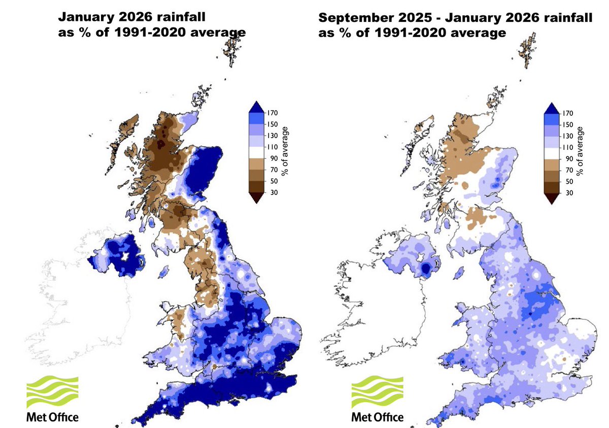
Good maps from @UK_CEH January Hydrological Summary showing just how wet it was for some parts of the UK during January and the Autumn/Winter period.
The relative dryness of western Scotland is also noteworthy.
https://t.co/0LmO221IMT
#StormBram has been named by Met Éireann and now meteorologist, Holly O’Neill, explains why it has been named, how it is developing and the impacts we can expect across the country from tonight.
#StormBram has been named by @MetEireann and is forecast to bring strong winds and heavy rain to the UK later on Monday and through Tuesday #WeatherAware
⚠️ Yellow weather warnings issued ⚠️
Heavy rain and strong winds from Monday evening to Wednesday morning
Latest info 👉 https://t.co/QwDLMfRBfs
Stay #WeatherAware⚠️
Over 100 mm of rain could fall across exposed hills in Wales and western England by the end of Monday - around half of what would typically be expected to fall throughout the whole of December 🌧️
Flooding and disruption is expected so take care if travelling ⚠️
⚠️⚠️ AMBER weather warning issued ⚠️⚠️
Rain across south Wales
00:00 Monday until 23:59 Monday
Latest info 👉 https://t.co/QwDLMfRBfs
Stay #WeatherAware⚠️
Students aged 19+ can still apply for Welsh Government Learning Grant FE. Household income under £18,370? Up to £1,919 in support is available – don't miss out. https://t.co/ZgHCJU7BCj #CymruStudentSupport
⚠️⚠️ Amber weather warning issued ⚠️⚠️
Heavy rain across central parts of England and Wales
Friday 1200 – 2359
Latest info 👉 https://t.co/QwDLMfS950
Stay #WeatherAware ⚠️
Potentially serious situation for tomorrow & Saturday
Severe flooding is possible as a result of very heavy and prolonged rainfall affecting entire river catchments.
Worst conditions look like eastern Valleys and the Wye, Dore, Lugg and Teme catchments.
Don’t take lightly.
Tomorrow’s forecast rain is concerning partly because it’s being forced by an easterly wind.
This will focus highest rainfall over eastern facing high ground, generally protected from prevailing SW winds.
Rivers in the circled area may receive a lot of water very quickly.
⚠️ Yellow weather warning issued ⚠️
Rain across parts of England and Wales
Friday 0600 – Saturday 0600
Latest info 👉 https://t.co/QwDLMfRBfs
Stay #WeatherAware⚠️