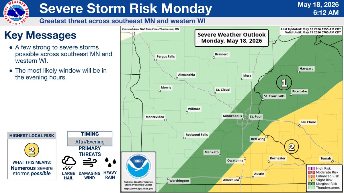
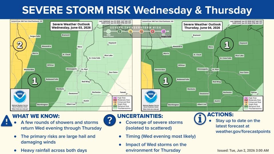
Today and Wednesday will be hot and humid with heat indices in the 90s. This heat will bring chances for severe weather tonight and Wednesday. Damaging winds are the primary threat tonight while all severe hazards (wind, hail, tornadoes) are possible Wednesday. #mnwx#wiwx
The severe risk extends east on Thursday, though confidence is low on the extent and timing of severe storms due to round of storms Wednesday night. See less
Some weather to keep an eye on. stay safe everyone.
From the National Weather Service:
Good Morning,
Confidence is increasing for an active stretch of weather starting Wednesday evening and lasting through Friday.
It is likely that some locations will exceed 1" where storms persist for several hours, and some areas could see well below an inch if storms avoid your area.
A few storms have the potential to become strong to severe, especially Wednesday evening across western Minnesota.
Another round of showers and storms are likely today, with a few strong to severe possible over southeast MN and west-central WI, though the best environment is to the south of us.
Burn Ban for Martin County:
The National Weather Service has issued a Red Flag Warning for 66 counties across Minnesota, effective today, April 20, until 8 p.m., due to extreme fire risk conditions.
Visit the National Weather Service (https://t.co/QeXfmH95Vp) for updates.
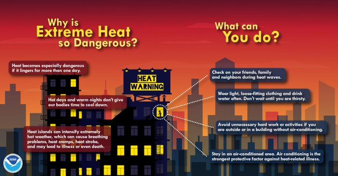
Warm temperatures can quickly rise to dangerous levels — especially in the summer and in parked cars.
Stay #WeatherReady and don’t underestimate the heat. https://t.co/PaQRcPKfFO #mnwx#wiwx
The final day of Severe Weather Awareness Week is Extreme Heat & Wildfires!
Finding relief from the heat and drinking plenty of fluids is vital to getting through a heat wave! Taking breaks and limiting time outdoors also helps. More info at https://t.co/ALG3Na1CuC #mnwx#wiwx
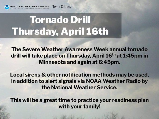
Tornado Drills will occur today at 1:45pm and 6:45pm for Minnesota.
This is a great opportunity to practice a tornado safety plan at work or home, and a great reminder that sirens are only meant for those outdoors!
More info at https://t.co/mwDPPvh6ih #drillsergeant
From NWS:
Day 4 of Severe Weather Awareness Week continues with road safety.
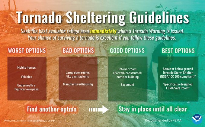
You know to take shelter immediately if your area receives a Tornado Warning. But what makes a good shelter? Take the time now to figure out your options. More info at https://t.co/8ycWQZM2zt #mnwx#wiwx
From NWS:
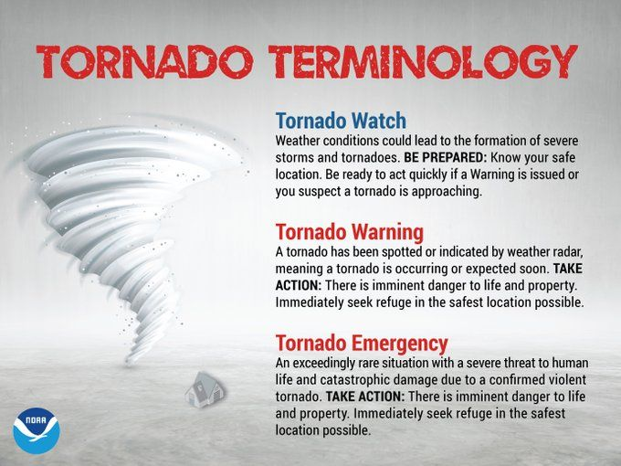
Day 4 of Severe Weather Awareness Week is about tornadoes!
Tornado Watches highlight where tornadoes are most likely to develop. Tornado Warnings mean a tornado is occurring or expected soon. Tornado Emergencies are for confirmed violent tornadoes causing damage. #mnwx
As a Reminder:
Today's topic for severe weather awareness week is Tornadoes. The sirens will be going off today at 1:45 and 6:45 PM in participation with the statewide tornado drills. Here is a website with some resources to help better prepare.
https://t.co/COcHiKBojF
NWS:
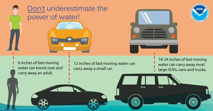
It is important to never drive or try to walk through flooded roadways. Not only do you not know what the road looks like beneath the water, it also can sweep you away very easily, even in a vehicle!
Turn around, don't drown! More info at https://t.co/sDqUoVoKe8 #mnwx#wiwx
From the NWS:
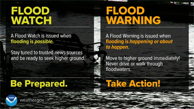
Day 3 of Severe Weather Awareness Week begins with the topic of flooding.
A Flood Watch means flooding is possible, while a Flood Warning means flooding is happening or will happen soon. Turn around, don't drown! More info at https://t.co/sDqUoVoKe8 #mnwx#wiwx
NWS:
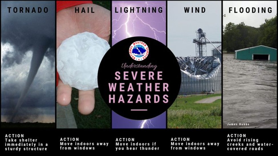
We cap off day 2 of Severe Weather Awareness Week by taking a look at the various hazards associated with thunderstorms.
Knowing what action to take ahead of time and having a plan in place is essential! More info at https://t.co/v7ixfIdOcc #mnwx#wiwx
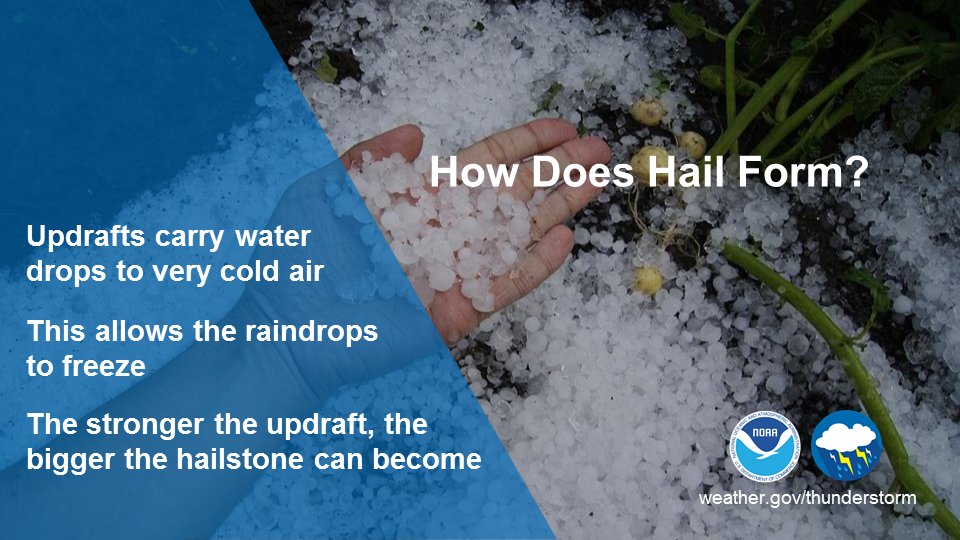
Day 2 of Severe Weather Awareness Week continues with hail! Hail occurs when water is lofted to sub-freezing temperatures within a storm. Hail is best measured next to a measurement device or common object, no marbles please! More info at https://t.co/v7ixfIdOcc #mnwx#wiwx
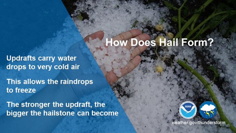
Day 2 of Severe Weather Awareness Week continues with hail!
Hail occurs when water is lofted to sub-freezing temperatures within a storm. Hail is best measured next to a measurement device or common object, no marbles please! More info at https://t.co/XH6qSzKdLm #mnwx#wiwx
Day 2 of Severe Weather Awareness Week begins with Lightning Safety!
We do not issue warnings for lightning, however all thunderstorms do contain lightning. When thunder roars, go indoors! More info at https://t.co/XH6qSzJFVO #mnwx#wiwx