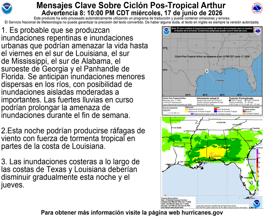
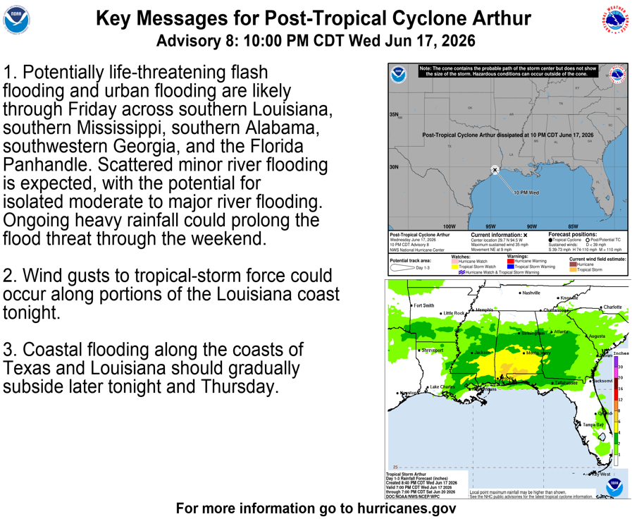
6/17 10 PM CDT Key Messages: Arthur degenerates to a post-tropical low. Life-threatening flash and urban flooding are likely over portions of the southern and southeastern U.S. through Friday. For more information, visit https://t.co/tW4KeGdBFb and https://t.co/SiZo8ozBbn.
Tropical Storm #Arthur Advisory 7A (7 PM CDT, Wed Jun 17): Center of Arthur Re-Forms Northeastward Near Galveston Texas. Life-Threatening Flooding Expected Across Portions of the Southeastern United States. https://t.co/tW4KeGdBFb
Tropical Storm #Arthur Advisory 7 (4 PM CDT, Wed Jun 17): Life-Threatening Flooding Expected Across Portions of the Southeastern United States. Tropical Storm Warning Remains in Effect for Portions of the Texas and Louisiana Coast. https://t.co/tW4KeGdBFb
Tropical Storm #Arthur Advisory 6A (1 PM CDT, Wed Jun 17): Tropical Storm Warning Remains in Effect for Portions of the Texas and Louisiana Coast. Life-Threatening Flooding Expected Across Portions of the Southeastern United States. https://t.co/tW4KeGdBFb
🛑 SIGNIFICANT RAIN FOR PARTS OF THE STATE
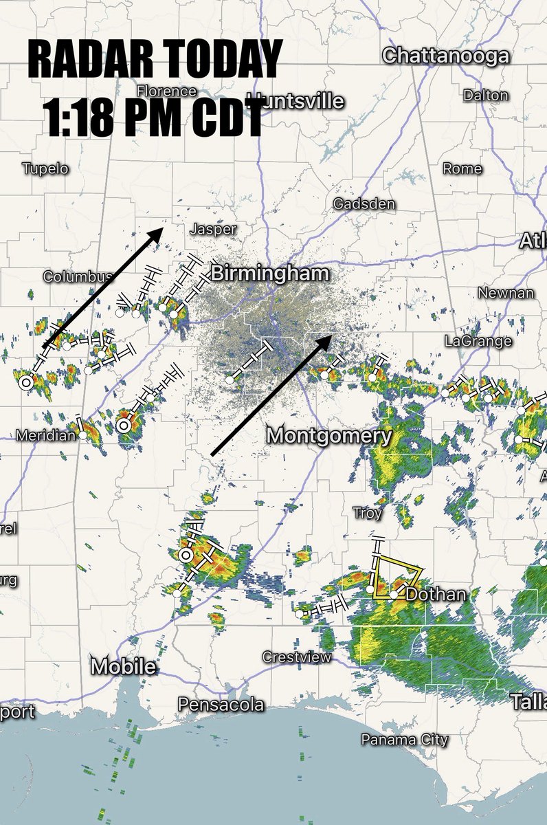
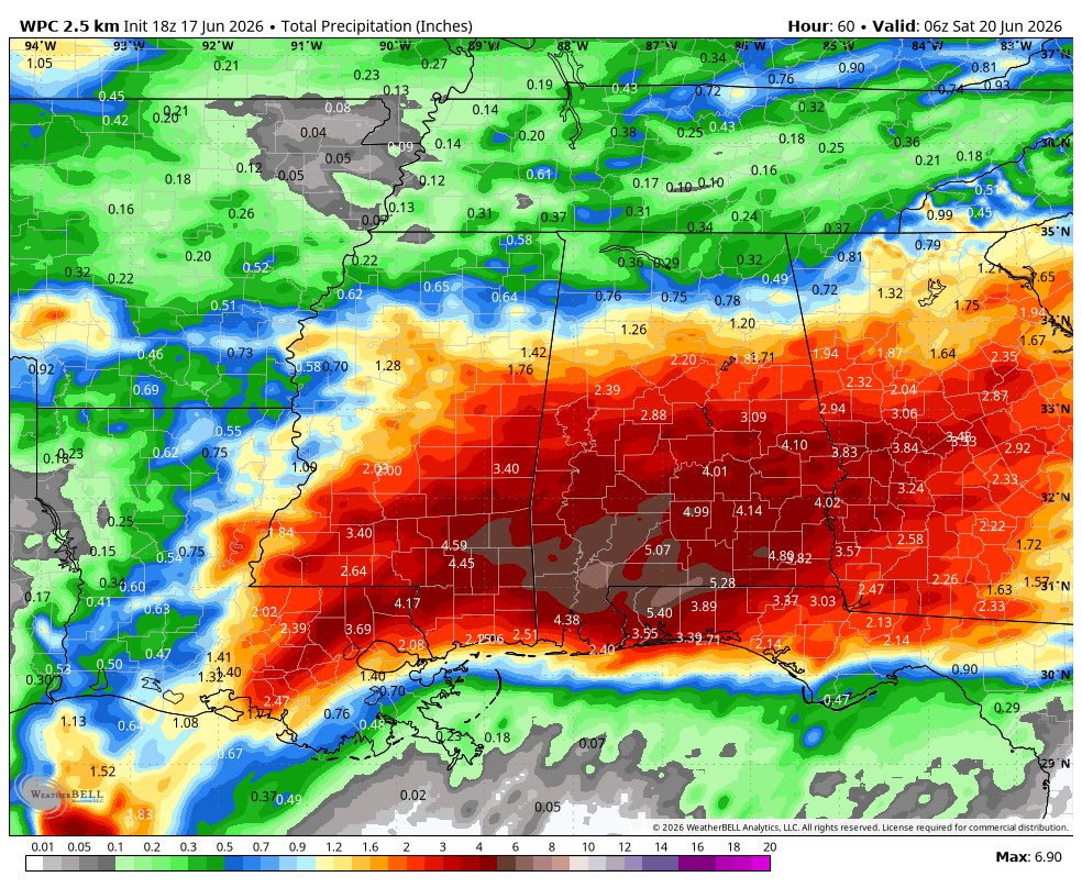
This afternoon’s radar shows scattered showers and storms lifting in from the southwest. Tropical Storm Author meanwhile, remains over the northwest gulf. The system moves inland and weakens but all the tropical moisture moves our way, with rain likely during the day tomorrow. This system will spread some significant rainfall across parts of the region. The highest totals occur over south Alabama where rain amounts could approach a half foot.
The main risk will be flooding, especially over our southern counties where rain amounts may exceed 4”. There could be similar totals in a few areas further north.
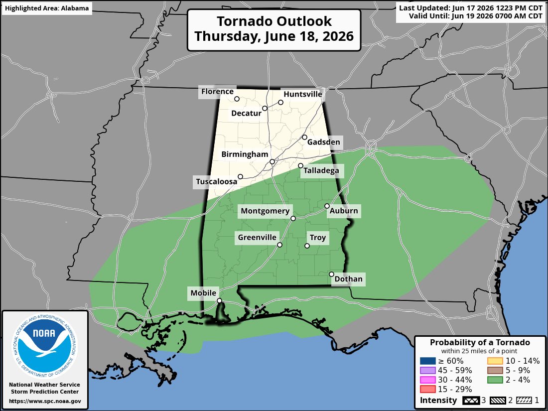
🌪️ Will we see a tornado risk? It’s low but non zero with a system like this. Greatest risk is east of the low, which would mean we need to monitor southeast counties. Also, with a system like this brief rotation can develop quickly and not last long, so stay weather alert tomorrow.
More rain and storms wrap in on the backside of the system Friday so the flood risk will continue before improving weather on Saturday.
📲 Stay with WBRC for continued updates on this system. First Alert Weather Days have been declared for Thursday and Friday.
Tropical Storm #Arthur Advisory 6 (11:30 AM CDT, Wed Jun 17): Tropical Storm Warning Extended Southward. Life-Threatening Flooding Expected Across Portions of the Southeastern United States. https://t.co/tW4KeGdBFb
June 17 1130AM CDT: Tropical Storm Warning extended along upper Texas coastline for Tropical Storm #Arthur. Stay up to date with the latest information at https://t.co/tW4KeGdBFb
Tropical Storm #Arthur Advisory 5 (10 AM CDT, Wed Jun 17): Tropical Storm Arthur Develops Near the Middle Texas Coast. Life-Threatening Flooding Expected Across Portions of the Southeastern United States. https://t.co/tW4KeGdBFb
Jun 17 10AM CDT: First Tropical Storm of the season forms in the Atlantic Basin. Here are the Key Messages for Tropical Storm #Arthur. For the latest information visit https://t.co/tW4KeGdBFb
I'm looking at one of the most active weather patterns I've ever seen for mid-June. Yes, you expect heat advisories, fire weather, etc. You don't expect to see a significant outbreak of severe weather in the Midwest, flood risk in the southeast, and tropical storm warnings. 🤯😬
Potential Tropical Cyclone #One Advisory 4A (7 AM CDT, Wed Jun 17): Low Pressure System Moving Northeastward Along the Middle Texas Coast. Expected to Cause Life-Threatening Flooding Across Portions of the Southeastern United States. https://t.co/tW4KeGdBFb
A flood watch is in effect from 7 am Thursday through 7 am Friday for most of Central Alabama. Heavy rainfall may cause localized flooding. A few storms may be severe Thursday and Friday with damaging winds possible both days and a tornado risk on Thursday.
Chances for showers and some storms today with best potential south. Highs in the 80s. Showers and some storms increasing tonight from the southwest, lows in the low 70s. Rain and storms Thursday, heavy rain may cause localized flooding, some storms may be severe. Highs near 80.
6/16 10 PM CDT Key Messages for Potential Tropical Cyclone One. Please visit https://t.co/tW4KeGdBFb and https://t.co/SiZo8ozBbn for the latest information.
Potential Tropical Cyclone #One Advisory 3 (10 PM CDT, Tue Jun 16): System Near the Texas Coast. Expected to Cause Life-Threatening Flooding to Portions of Texas and Louisiana. https://t.co/tW4KeGdBFb
Heading to the beach this weekend? Be careful in the surf as a HIGH rip current risk is expected along the Alabama Gulf Coast through at least the next 5 days. Always swim near a lifeguard and know what to do if caught in a rip current friends!🚩🌊
#alwx#ripcurrents#wbrc