UPDATE: The Army still plans to set off the lead azide blast in southeast Iowa by Tuesday, but the wind has FLIPPED since Friday's forecast...
A court has paused the permit for now, but the Army says the degraded explosives are an emergency. No time has been set yet.
If it happens Monday, a northwest wind would carry the plume southeast, toward Wever, Dallas City and La Harpe, Illinois. If it's Tuesday, a lighter northeast wind would push it southwest, toward West Point, Donnellson and Montrose.
Either way, the towns from Friday's map to the north are no longer in the path, and the Army will release its own plume map shortly before the expected detonation.
Records from 1913 have fallen AGAIN...
One day after the Upper Midwest had its warmest late-November day on record, Saturday did it again. Highs that had stood since 1913 fell in five cities, including Madison, Green Bay and Traverse City, and four more tied.
This marks two days in a row that records that had stood for 113 years were broken.
The chances of this storm off the Southeast coast becoming Kyle are dropping fast...
It’s now down to just a 10% chance of developing, as it moves north into conditions that won’t allow for it to become tropical.
However, gusty winds, dangerous surf, rip currents and coastal flooding will continue for the Southeast to the Mid-Atlantic coast into early next week, along with heavy rain and flash flooding for the coastal Carolinas and Mid-Atlantic this weekend.
A low moving in from the Gulf could spark a brief tornado or two across South Florida this afternoon, including the Miami, Fort Lauderdale and West Palm Beach areas!
Thanksgiving Day is looking WET for much of the East Coast...
Rain moves into the Southeast on Wednesday, then spreads up the coast Wednesday night. It looks steadiest on Thanksgiving Day itself from Norfolk and D.C. to New York and Boston. A few showers could linger into Friday before things dry out by the weekend.
The good news: Wednesday, the big travel day, looks mostly dry from D.C. to Boston until the evening!
This has NEVER happened this late in the year in recorded history.
Minneapolis, Madison, Milwaukee and Green Bay all climbed into the mid to upper 60s yesterday (11/20).
Each city has hit temperatures like this this late in the year before, but only a handful of times in over 140 years, and never all four on the same day. The closest was 1913, when three of the four did it.
The Upper Midwest just had its warmest late-November day in recorded history.
Parts of Brevard County, Florida, have now picked up 2 FEET of rain twice in the same month...
A gauge near Cocoa Beach measured 24.26 inches in just the last 3 days, and Merritt Island has picked up 22 inches.
It’s the 2nd time this month: from 11/1 to 11/3, a gauge near Grant-Valkaria in south Brevard measured almost 25 inches! Just over two weeks later, the same county got hit almost as hard again.
Ski season in California just went from zero to 6 FEET in 8 days...
Three storms since last Thursday have dumped over 6 feet of snow on the state’s highest peaks, with 79 inches at Lassen Park and about 4 feet at Kirkwood, Tioga Pass and Mammoth Mountain.
A week ago, there was almost no snow on the ground anywhere in California’s mountains.
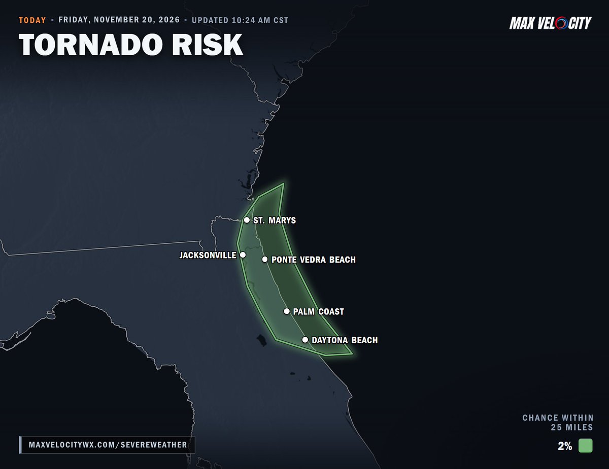
On top of the flooding, a brief tornado or waterspout can’t be ruled out along the northeast Florida coast this afternoon and tonight, from Daytona Beach and Palm Coast up through Jacksonville!
I got to meet the LEGENDARY forecaster Chris Broyles, alongside so many other incredible meteorologists at the Storm Prediction Center!
It was an absolute honor to tour the Storm Prediction Center in Norman, Oklahoma, and get a behind-the-scenes look at how they forecast severe weather.
The technology, expertise, and dedication that go into these forecasts on a daily basis is truly incredible.
Huge thank you to everyone at the SPC for taking the time to show me around!