Read all about it 📢🗞️! Data collected by your favorite blue radar during the @NSF BEST project in the Greenfield, IA tornado revealed winds over 300 mph in town, and first-ever mapping of Linear Dual Polarization (LDR) in a tornado, what winds destroyed wind turbines. Link ⬇️
That's hail, not snow! 🧊 Severe thunderstorms swept through southeastern Pennsylvania on Thursday, leaving piles of hail up to 19 inches deep and forcing a road closure in Brookhaven.
For a flash freeze to occur, air temperatures must be 32°F or lower. As such, snow squalls can happen anytime between November and March.
Remember this video when snow squalls are in the forecast. There is no safe place on a highway during a snow squall.
#SnowSquallSafetyPA
@VinceWaelti@a_dose_of_wx Wild times for the radar community. If there’s one takeaway, it’s that listening to your users matters more than anything. Fortunately, there are some fantastic teams pushing weather technology forward. Love what you guys are building!
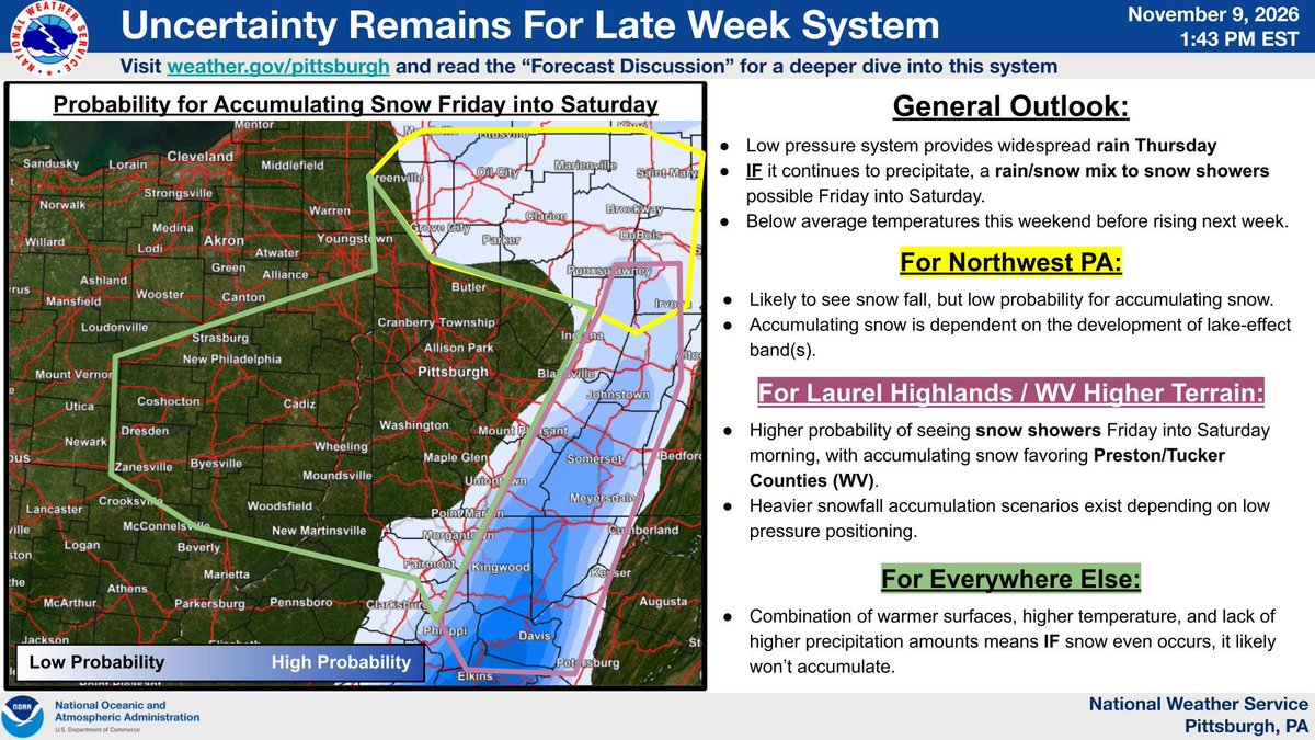
Here's an update on snow potential during the late week/weekend period. Confidence is still highest in the Laurels/WV ridges, with spottier chances at best elsewhere. A large portion of the region may see non-accumulating flakes. More details to come over the next couple of days!
A storm system will likely bring the first accumulating snow to the higher elevations of the central Appalachians and the interior Northeast late week into the weekend. In the low elevations, precipitation will mostly fall as rain. Visit https://t.co/D8jZlzOsbd for more details.
The Pacific Northwest continues to be closely monitored by @NOAA’s #GOESWest (#GOES18) 🛰️ today. #GaleWarnings have been issued along the coastline of the region, where rain and snow from Pacific storm systems is expected.
For more information: https://t.co/dCLQuXK3jp
You may have seen/heard/whispered about the potential for snow late this week. So what do we think of it?!
Here is an overview of what to expect and where the potential for accumulating snow is highest. Continue monitor the forecast trends in case these probabilities change.
#FloodWatches and #FloodAdvisories are in place in southern Texas this morning, where rainfall is expected. This water vapor imagery captured by @NOAA’s #GOESEast (#GOES19) 🛰️ highlights the high concentrations of moisture currently present over the region.
Learn more: https://t.co/DsjXh9jvlf
Our theme for Snow Squall Awareness Week is simple: There is no safe place on a highway during a snow squall.
After you watch this video, you'll see why.
Stay tuned all week long to learn more about this dangerous winter hazard.
#SnowSquallSafetyPA
Baltimore First Snow Update: Inverted Trof? See that yellow line on the Friday forecast (Euro) map below? 👇 It looks like something called an "inverted trof" to me. And if this were the heart of winter, snowhounds would be howling! 😁 Why? Because the area under this type of feature can get smoked with heavy snow. But it's not the heart of winter! It will likely be too warm during the day around Baltimore for stickage. Maybe just a cold rain, with a little snow mixed in. Still a few days to track, so stay tuned...❄️🚂
Enhanced color imagery from @NOAA's #GOESWest (#GOES18) 🛰️ shows several weather systems impacting the contiguous U.S. today.
A Pacific frontal system is bringing rain to parts of the West Coast, while a low-pressure system over the central U.S. is expected to produce showers and #thunderstorms. Meanwhile, another area of low pressure over Florida is also bringing rain to the region.
Latest updates and advisories: https://t.co/DsjXh9jvlf
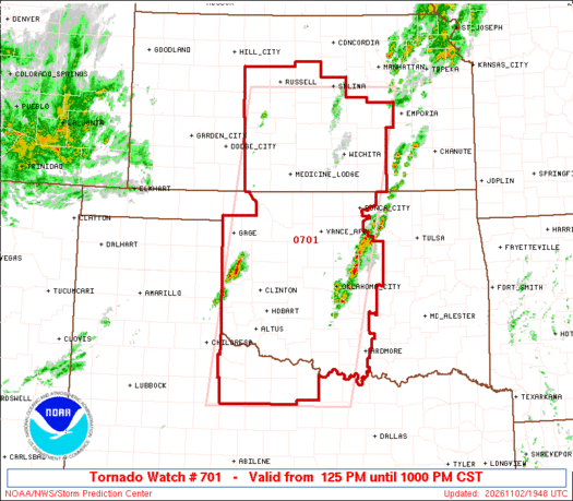
A #tornado watch is in place in western and central Oklahoma, central Kansas and a small part of western North Texas.
There will likely be two rounds of storms - this is the first round. A few tornadoes are likely (a couple possibly strong). #OKwx#KSwx#TXwx