I'm definitely keeping my eye on the Gulf, not so much for the current disturbed weather, but for what potentially follows. There are plenty of hints in the long-range ensemble data showing a potential low pressure system moving northward through the Gulf around the weekend of the 13th/14th. An Eastern Pacific -> Central America -> Gulf crossover disturbance. Could be a tropical system, so I'll be tracking this potential closely.
This year definitely has the feel of producing some kind of a lower-end named storm in the Gulf in June. That's just a nearly three-decade-long-career-meteorologist's-gut feeling! 😆
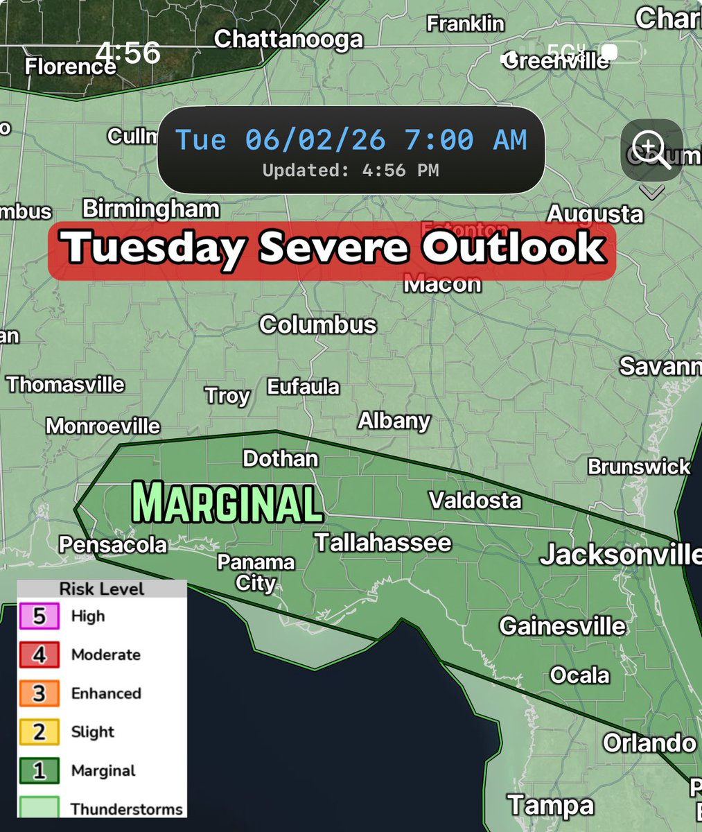
⛈️ Remain weather-aware Tuesday afternoon across the Southeast as isolated to scattered showers and thunderstorms will pop. The overall coverage is questionable, as you can see from two of the main short-range, hi-res models. The SPC has part of the area outlined under a Marginal Risk, level 1/5. Depends how this impulse moving in from the northeast triggers convection during the heating of the day.
🖊️ Bottom line: Any storms that form could produce gusty winds and some hail, along with heavy downpours and frequent lightning. The movement will be generally southward or south-southwestward. The threat will increase through the afternoon, then wind down Tuesday evening.
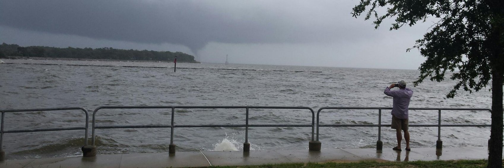
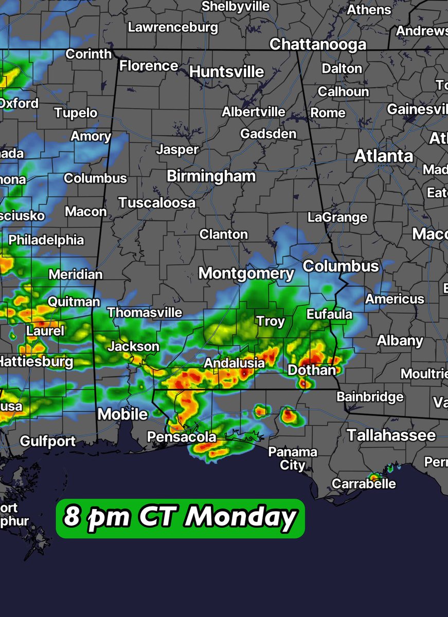
A significant line of showers and thunderstorms is moving southward across North Alabama early Monday afternoon. There’s certainly a chance this makes it into South Alabama this evening. A good day to keep an eye on the radar! ⛈️ Gusty winds are possible at times. 💨
More scattered showers and thunderstorms are on the way for Monday and Tuesday and a few stronger thunderstorms could produce gusty winds, frequent lightning and locally heavy rain.
The Storm Prediction Center has parts of the South outlined in a Marginal Risk for both Monday and Tuesday.
Looking at the latest guidance, Monday will feature scattered thunderstorms dropping southward. A few stronger cells may survive into Southeast Alabama, but widespread severe weather is not expected. Tuesday looks similar with scattered afternoon and evening thunderstorms, some capable of brief strong wind gusts. The overall severe threat remains isolated, but worth recognizing and paying attention to.
A definite westward shift this weekend in the placement of weak energy in the Gulf over the days ahead. Looks like the focus will be towards Texas later in the week with deep moisture, while high pressure takes hold over the Southeast.
🌧️ Wet weather in Texas/Louisiana.
☀️ Dry stretch for Alabama/Georgia/Carolinas/much of Florida.
🏖️ Beach plans looking good!
🚜 Outdoor work made easier!
Lots of model support for this - I’ll keep watching it.
Quick reminder as we approach tropical season. If you’re seeing the GFS model posted with crazy phantom storms, question it. Tropical forecasting is WAY more complicated than posting a GFS run. It’s an inferior model as-is and the latest 30-day model verification reinforces that. Unless/until there’s development consensus with the various ensemble data and AI modeling, there’s not much to worry about. GFS posts are usually for engagement farming.
Pretty good 72-hour rain totals across the South. 🌧️ We *really* needed this moisture.
There are still some weak spots on the map that haven’t seen much. If that’s you, hang in there…rain chances remain elevated for the week ahead.
Warm and humid this weekend with “popcorn” showers and thunderstorms across the Deep South. ⛈️ Some get wet, some do not. Beware of lightning strikes if they move in. Most of these will be quick-hitting, moving generally northward.
NOAA is forecasting a below normal Atlantic hurricane season for 2026, with 8-14 named storms, 3-6 of those becoming hurricanes and 1-3 of those becoming major hurricanes. The main reason for the lower numbers is the development and likely persistence of El Niño, which can help suppress tropical activity in the Atlantic, especially in the Main Development Region.
That said, it only takes one storm to make for a dangerous season, so now is the time to review your hurricane plan and take inventory of supplies. While El Niño typically increases wind shear in the Caribbean and Atlantic - which can help limit storm formation - the Gulf is less susceptible to the influences of the El Niño Southern Oscillation phase.
Forecast technology continues to improve as NOAA is adding new AI-based models, drones, upgraded satellite data and enhanced flood mapping tools to its arsenal this year to improve forecast accuracy and warning lead times. Get ready, the Atlantic Hurricane Season begins June 1!
This year just has the feeling of featuring a sloppy June tropical system. There's now a hint of that potential in the long-range ECMWF Ensemble, looking into the first week of June. The ECMWF sub-seasonal weeklies also show this potential, with lower-than-normal mean sea level pressure for the first couple weeks of June across the Gulf and Southeast US.
No guarantees on this, but definitely something to keep in mind if you have any beach or coastal plans as we head into June.
Warm and humid weather continues this week, with highs reaching the upper 80s to lower 90s. Throw in the extra humidity and isolated pop-up PM showers and thunderstorms will result. 🌧️
Pinpointing exactly where the rain will fall is difficult, so use these images as a general guide. The main window for the hit-or-miss activity will be from around 4 pm to 9 pm daily.
We’re flipping the switch this weekend from comfortable spring weather to some early-summer heat! Lows in the 50s early Saturday…highs well into the 80s. We’re only going up from here! 😎 🥵 🏝️
We made a dent in the drought, but it’s not going away. The latest ECMWF Ensembles projection of rainfall through 1 pm next Saturday (May 23) paints a pretty dry picture across the Wiregrass and beyond, with many spots struggling to even pick up a half-inch of rain over the next 10 days. That’s not exactly what you want to see heading deeper into May with the heat and humidity about to crank up.
We may get a few pop-up afternoon thunderstorms here and there, but widespread soaking rain? That signal just isn’t showing up right now. Lawns, gardens, farms and ponds are going to feel the stress again, starting early next week.
There’s going to be a bit of a chill in the air for the early-mornings ahead. Friday and Saturday look to feature widespread 50s, which is nearing record territory across the South. This is due in large part to a batch of unusually dry air moving in starting Thursday.
A shift occurs this weekend, though. Temperatures begin to rise with highs reaching the upper 80s to lower 90s in spots. If you’re longing for summertime weather and the pool or beach…it’s coming! 🏖️ 🌴
An exciting day for meteorologists as the ECMWF (European Centre for Medium-Range Weather Forecasts) upgraded their physics-based IFS model and their AI-based (AIFS) model, plus ensembles.
These improvements will help me - and others - produce even better forecasts. The ECMWF data are key tools in the forecasting toolbox. Always exciting to see improvements to the profession I've dedicated my life to!
🚨 Alert…next week is going to be HOT!! 🚨
Enjoy these cooler readings while you can, because the atmosphere is about to hit the “flip to summer” switch across the Deep South.
The transition begins this weekend with highs reaching the upper 80s to lower 90s in spots. The humidity starts creeping back in, too. Next week is looking downright summerlike across the entire Southeast. Some areas could be pushing heat index values well into the 90s by the middle of the week.
We’re basically going from “I can’t believe it’s so cool for the middle of May” to “I can’t believe it’s so hot and humid” in a matter of days! 😂
Wow, what a cool blast for the end of the week! 🥶 Lows in the lower to middle 50s on May 15 is a rarity across the South. Soak it in because the upper 80s to lower 90s for highs quickly return this weekend! 🥵 Summertime weather is on the way! 😎