🌪️TORCON 4 TODAY🌪️
-There is a risk of tornadoes today centered along I-35 at the Kansas and Oklahoma state line. This is a relatively confined area, considering thunderstorms are expected from Wyoming to New York. Be safe everyone!
THUNDERSTORMS & TORNADOES
-TORCON 3 in Colorado and Wyoming. A few tornadoes are possible today in relatively good chase locations, so watch the livestreams today. Otherwise, widespread thunderstorms could produce hurricane force wind gusts of 75mph. This will include Abilene, Oklahoma City, Tulsa, and Wichita.
-Severe thunderstorms are also possible in the Delmarva and Eastern North Carolina. Damaging wind would be the main threat.
Be safe everyone!
#weather #WeatherUpdate #tornado
⚡️A TON OF STORMS TODAY⚡️
-After a weekend that saw nearly 50 tornadoes, more storms return today. While the risk for tornadoes has abated some, numerous thunderstorms with winds 60+mph are likely to occur from New York to Alabama. Imbedded tornadoes are possible. The storms should begin by early afternoon.
-Thunderstorms with large hail(2”+) are the concern in Eastern Colorado, Western Nebraska, and Eastern Wyoming.
-This week looks to stay active with storms in a variety of spots. Look for updates each morning.
#weather #WeatherUpdate #hail
🌪️FATHER’S DAY TORNADOES🌪️
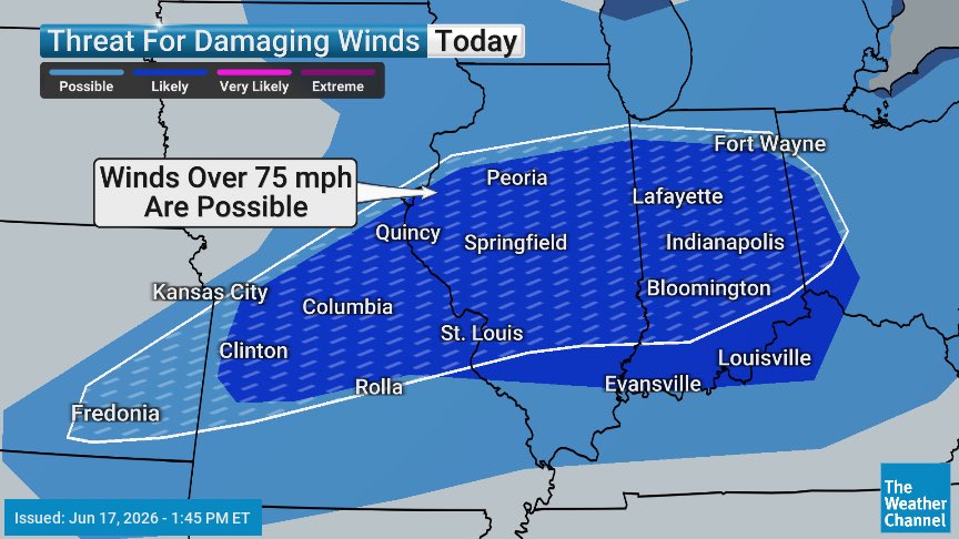
-There is a risk of tornadoes today with a TORCON 4. Areas affected include, Indianapolis, Evansville, Louisville, St Louis, Springfield, and Joplin. A cold front will drape across the Ohio Valley and back into the Texas Panhandle. A few strong tornadoes are possible, as well as large hail and very gusty winds.
-Storms will be present this the morning in Iowa. Kansas and Missouri. More storms continue east through the day and reintensification is likely by late afternoon.
-Large and destructive hail is possible from Illinois to Colorado. Hailstones could reach 2” in diameter or larger. Park your car in a garage if possible.
Be safe everyone and Happy Father’s Day!
#fathersday #weather #tornado
🌪️LATEST TORCON MAP🌪️
-TORCON remains a 7. Minor tweaks to the map, but largely the same message: large and strong tornadoes, extreme straight-line winds, and large hail. The weather will be rough across the Midwest through tonight.
-Have a sturdy place to shelter from the storms before they strike. Be mindful of trees around your property and the possibility of them falling on your home or vehicle. Consider staying off of second story and do not drive during these storms if at all possible.
#weather #WeatherUpdate #tornado
🌀NEW🌀
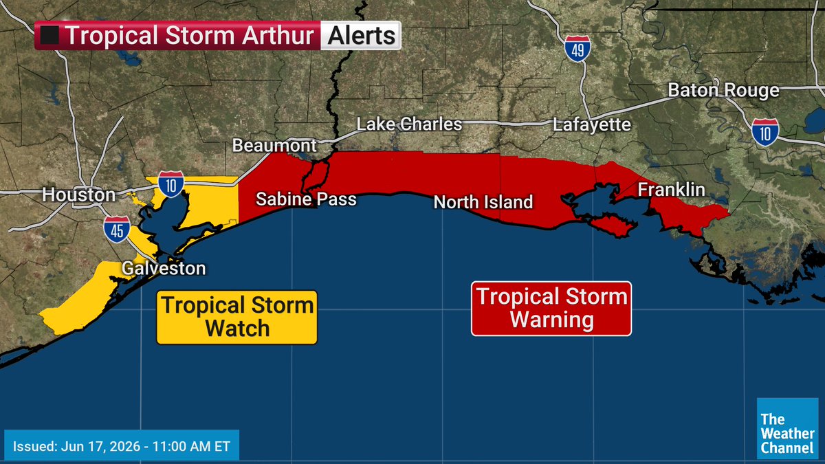
Tropical Storm #Arthur forms off the Texas coast. Tropical storm warnings have been expanded. The biggest threat remains heavy rain and flooding in the coming days.
🌪️VIOLENT WEATHER DAY AHEAD🌪️
-A severe weather outbreak is likely across the Midwest with a TORCON of 7 in Illinois and Indiana. On the 1-10 scale, this is a medium/high risk for large, destructive, and long-track tornadoes. Areas from Michigan/Ohio to Missouri should be on alert for numerous tornadoes, as well as hail over 2” in diameter and straight line wind gusts in excess of 75mph. Please be ready to shelter at a moment’s notice inside a safe structure. A mobile home is not safe in these circumstances. Please find alternate refuge.
-Storms will be present this morning, and a strong bow echo has produced 90+mph winds already, but the atmosphere should recover enough to produce a very intense outbreak by mid-day. Severe thunderstorms and tornadoes could last a few hours past dark. This could be a dangerous scenario, as you head to bed. Make sure your cell phone is nearby so you can receive the warnings. All newer smartphones receive the warnings automatically from the National Weather Service. A NOAA weather radio is a great backup to have as well.
-I’ll try to post updates throughout the day as warranted(they’ll be warranted).
Be safe everyone.
#tornado #weather #ilwx #inwx
🌀POTENTIAL TROPICAL CYCLONE 1🌀
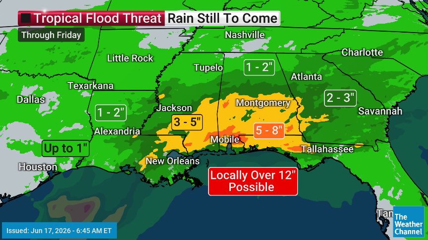
-The disturbance in the Gulf still has the potential to become Tropical Storm #Arthur today. Tropical Storm watches and warnings have been issued. Minor storm surge and nuisance winds will take a backseat the extreme rainfall headed for the southern states. A large swath of 3-5” is expected, with isolated areas of 12”. This will cause widespread river and flash flooding. Avoid driving on any water-covered road and monitor water levels closely if you live by a creek or stream. Be prepared to evacuate if orders to do so.
#weather #ptc1
94MPH WIND GUSTS!!
-Storms this morning are producing extreme winds. A serious gust was reported near Marshaltown, Iowa This is NOT the big event. That happens later this afternoon. Don’t be fooled by what happens this morning. The atmosphere reloads by midday.
-I’ll post another update around 9/8ct with the latest outlook, but his one has all the signatures of a bad day.
🌀TROPICAL STORM ARTHUR??🌀
It’s becoming increasingly likely we’ll have Tropical Storm #Arthur. Tropical storm watches have been issued for Texas and Louisiana.
We’re living in the future. My first experience with #Waymo
The ride was surprisingly pleasant. It drives smoothly. Its reaction time seems faster than humans. It’s wildly intuitive. I was impressed.
104 matches. 3 nations. 16 cities. But for the world-class athletes competing in 2026, the toughest opponents will be the weather. 🌎⚽️
From grueling altitudes to suffocating humidity, @mikebettes breaks down the science of playing in North America using Immersive Mixed Reality.
*BREAKING*
TORCON upgraded to a 7. There is a likelihood of intense EF3+ tornadoes today in Iowa and Illinois. This threat is very close to Chicago. Please be weather alert today and have plans to be in a safe structure when the storms arrive this afternoon/evening.
🌪️HEARTLAND GETS HAMMERED🌪️
-Yet another day of intense storms with a threat of tornadoes. TORCON 5 today in Illinois, Wisconsin, Iowa, and Missouri. This does include the Chicago metro. There will be morning storms and another round this afternoon/evenjng. The storms should form a squall line tonight and begin to die down after sunset. Some strong tornadoes(EF2+) are possible. Bow echos are likely to form as well, with extreme winds of 75+mph in the forecast. Monitor conditions closely today and have a safe place to goto should a tornado or severe thunderstorm warning be issued. Be safe everyone.
#weather #tornado #chicago