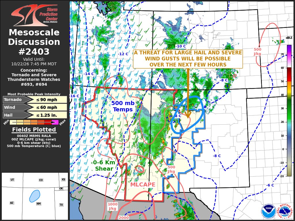
A threat for isolated large hail and a few severe wind gusts may continue for a couple more hours across parts of western and north-central New Mexico.
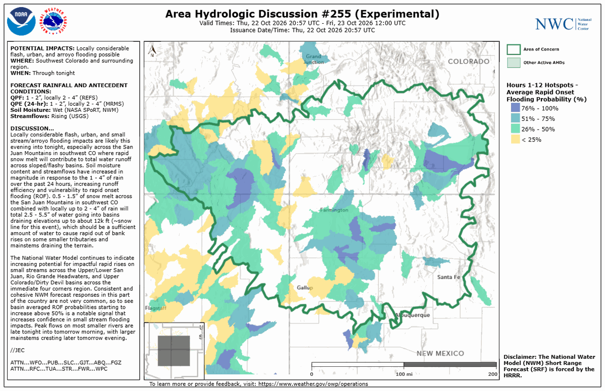
The National Water Center has issued Area Hydrologic Discussion #255 across portions of the Four Corners Region through tonight. Please visit the link below for additional info: https://t.co/Ej4glFqoTd
Continued threat of heavy rainfall across northwest
Arizona into southwest Utah and southeastern Nevada as scattered thunderstorms move over the area from the south. Rainfall rates between 0.5-1"/hr are plausible leading to potential isolated to widely scattered instances of flash flooding.
Heavy rain and a risk for flash flooding will affect the Southwest today and tonight, especially across southern UT and southwest CO, shifting to the Plains this weekend.
Meanwhile, unseasonably warm weather stretches across the Central US and into the Great Lakes.
Heavy rainfall is expected across the Four Corners region today with the heaviest precipitation occurring over southern facing terrain. A moderate risk of excessive rainfall is in effect for portions of southern Utah into southwestern Colorado. A broader slight risk is in effect across the Four Corners states and into southern Nevada. Visit https://t.co/qk3BcVP5M8 for your local forecast updates including watches and warning!
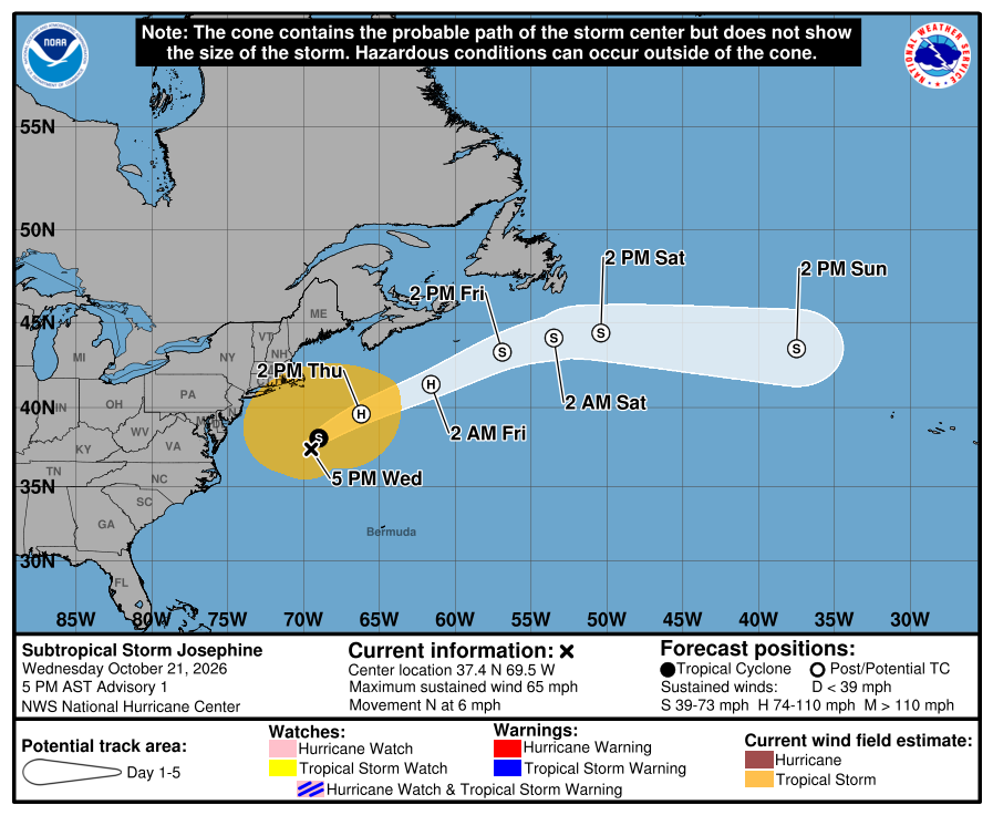
The area of low pressure well off the Mid-Atlantic Coast has acquired enough subtropical characteristics that it is now considered a Subtropical Storm, named Subtropical Storm Josephine. The latest track from the National Hurricane Center as of 5 PM EDT on October 21st is shown.
Here's a satellite loop showing the sun beginning to set on Subtropical Storm Josephine as it spins well offshore. Gusty N/NE flow will persist through Thursday AM. Direct impacts from this system remain minimal with spotty minor coastal flooding for the most vulnerable spots.
A Moderate Risk ERO is in effect tomorrow across portions of Southwestern Colorado. Rainfall totals of 2-3 inches, local 5 inches, atop snow melt on higher terrain will allow for locally significant flash and riverine flooding. The Four Corners may see scattered flash flooding.
Locally heavy rainfall potential will continue across
the Transverse Range and adjacent coastal areas of southwestern California over the next several hours, allowing for isolated to widely scattered flash flood chances into the evening.
Oct 21 Wed afternoon: NHC is monitoring 2 systems over the central and NW Atlantic Ocean. The westernmost one (Invest #AL93) has a 50% chance to become a subtropical storm, with low chances for the system well E-SE of Bermuda. More: https://t.co/GrztW6nozt
A very strong El Niño is underway in the Pacific Ocean, but what does that mean for weather around the world? 🌧️🌪️
Find out during the final talk in our 2026 NEDTalk series!
Dr. Andrew Hoell, a NOAA research meteorologist, will explore how changes in tropical ocean temperatures can influence storm tracks, rainfall, hurricane activity and agriculture worldwide.
Date: Friday, Oct. 23, 2026
Time: 12:00 p.m. EDT
Register for the live broadcast and ask your questions!
https://t.co/V5SnNXJFkU
#NEDTalks #ElNiño #ENSO
.@NOAA’s #GOESEast (#GOES19) 🛰️ continues to track the #NorEaster off the East Coast this morning, which is expected to slowly pull northward later today. #CoastalFlood Advisories remain in effect along the Mid-Atlantic coast.
This imagery was captured yesterday, Oct. 20, over the course of roughly four hours.
Latest updates: https://t.co/FdGeSaDj7C
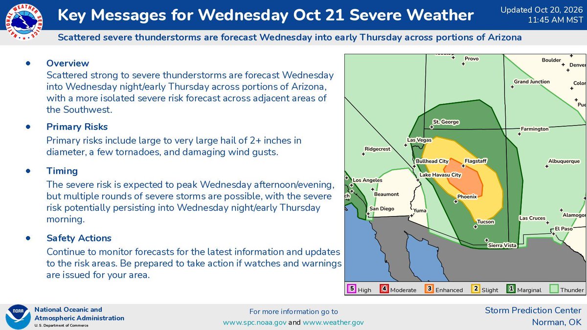
A rare risk for tornadoes and severe weather exists across both the Desert Southwest and the Southern California Coastline today. Ensure you have multiple ways to receive weather alerts and warnings!
https://t.co/o5cxJlONPR
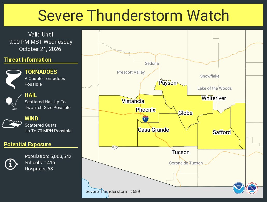
Severe thunderstorms including large hail and tornado risks are expected on Wednesday especially across Arizona and nearby parts of the Four Corners area and Lower Colorado River Valley. A localized severe risk may also exist along the coast of central/southern California.
⚠️ High Wind and Coastal Flood/High Surf Watches are in effect later this week. Monitor the forecast for updates, gather belonging, tie down, secure, or shelter loose objects, and consider how strong #winds and coastal flood may affect your plans. #AKwx#coastalflood#Kuskokwim
A moderate storm is expected to impact Southern California Wednesday through Thursday. Isolated to scattered thunderstorms are possible. Minor flooding and debris flows possible near recent burn scars. #CAwx#SoCal#LAWeather
A strong Pacific weather system will bring a deep surge of moisture to the southwestern US Wednesday and Thursday, with periods of widespread showers and thunderstorms expected. A Flood Watch is in already effect for Wednesday and Thursday in much of Arizona. Monitor https://t.co/qk3BcVP5M8 for the latest.