Hey everyone!
I'm Meteorologist Mike Witcher. Owner/operator and Chief Meteorologist for eastTNweather.
An all digital weather platform for East Tennessee.
Here's the early morning satellite and radar.
High pressure sits over the Mid-Atlantic, a cold front is still way back in the northern Plains, and the only rain is down across Georgia and Florida.
Nothing to worry about around here as high pressure dominates our weather pattern.
@KnoxMission@KARMStores
Knox Area Rescue Ministries is a Christ-centered nonprofit dedicated to serving the homeless and vulnerable in the Knoxville area. Through shelter, meals, recovery programs, and supportive services, KARM works to restore lives with compassion, dignity, and hope.
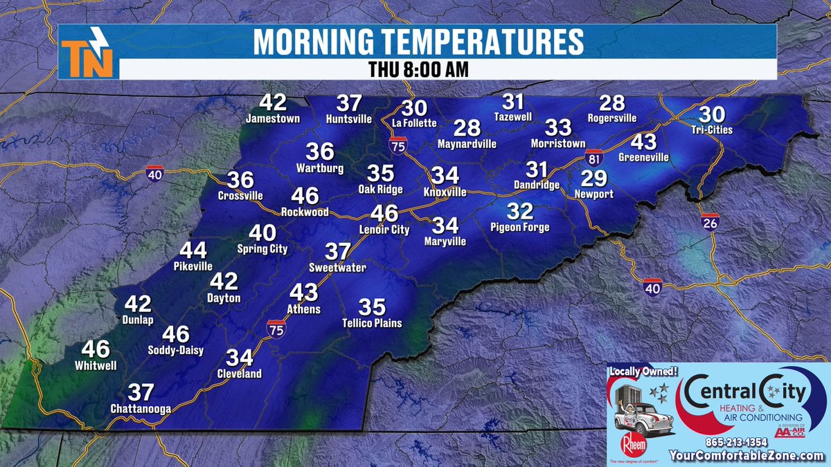
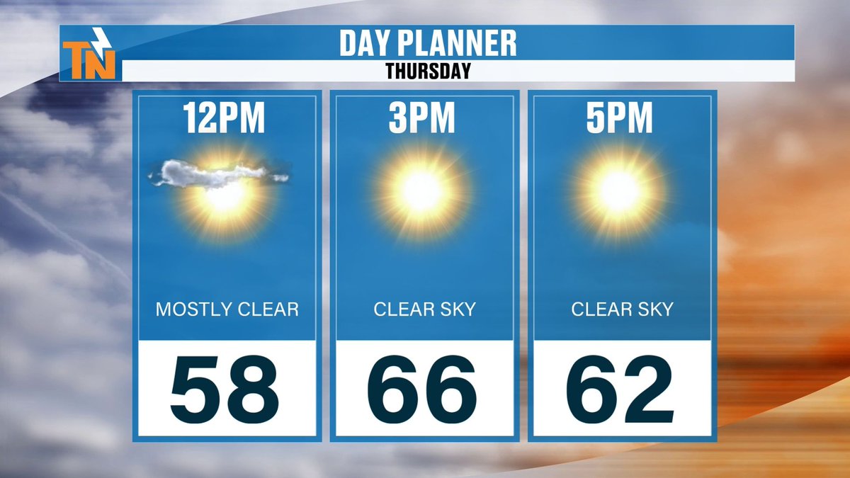
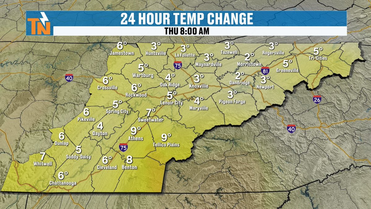
A little frost to start the day, with Maynardville and Rogersville at 28, the Tri-Cities at 30, Knoxville 34, Crossville 36 and Chattanooga 37. It's warmer than yesterday morning, though: Knoxville is up 3 degrees and Athens is up 9. Then we climb to 58 at noon, 66 at 3 and 62 at 5 under mostly clear skies.
Locally owned and operated, AA Air with @centralcityhvac. Serving the greater Roane County and Knoxville Metro area, keeping you in your Comfortable Zone for over fifty years… visit your comfortable zone (dot) com or call 865-213-1354
Central City Heating and Air Conditioning; keeping you in your Comfortable Zone for over fifty years @aaaircompany.
Good Thursday morning, East Tennessee.
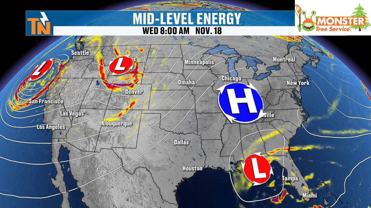
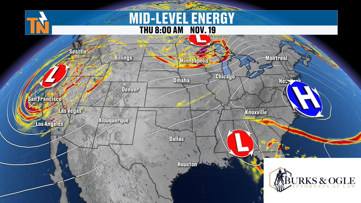
High pressure is parked off the East Coast, so we stay quiet, while all the stormy weather is way out west over California, the Cascades and the Rockies.
A weak low down near the Gulf Coast is the only thing worth noting on this mid-level map.
At @burks&ogle we’ve built a reputation for delivering strong outcomes. Our attorneys combine experience, focus, and a personal approach to every case we take.
We make sure you understand your options from the start. Then we help you build a clear, proactive strategy designed to win.
Watch the mid-level energy from Wednesday the 25th through Sunday the 29th. There are a lot of disturbances zipping across the country, and by Friday and Saturday they wrap into a big storm over the center of the country and the Ohio Valley. That's what could bring unsettled weather during the holiday travel weekend. We're still a week out, so I'll keep modifying the forecast. Download the free eastTNweather app to follow along. You can add up to 10 cities and get alerts for the ones you care about.
East Tennessee Basement Waterproofing the right way. The American way.
@americanfwusa
More on that Thanksgiving week pattern. The Saturday after Thanksgiving shows the cold pocket sitting over the central US. On Sunday the 29th, the rainfall map has a wide band of heavy rain across the Mississippi Valley and into the Southeast, and the snowfall outlook has snow across the Plains and upper Midwest, with a little mountain snow possible over the Appalachians late in the week. This is long-range guidance, so expect changes, but it's a good reminder to check the forecast before you hit the road.
@amelsecpa is a public accounting firm that serves businesses and individuals with Tax, Accounting/Bookkeeping, and Consulting needs. Our job is to make your job easier!
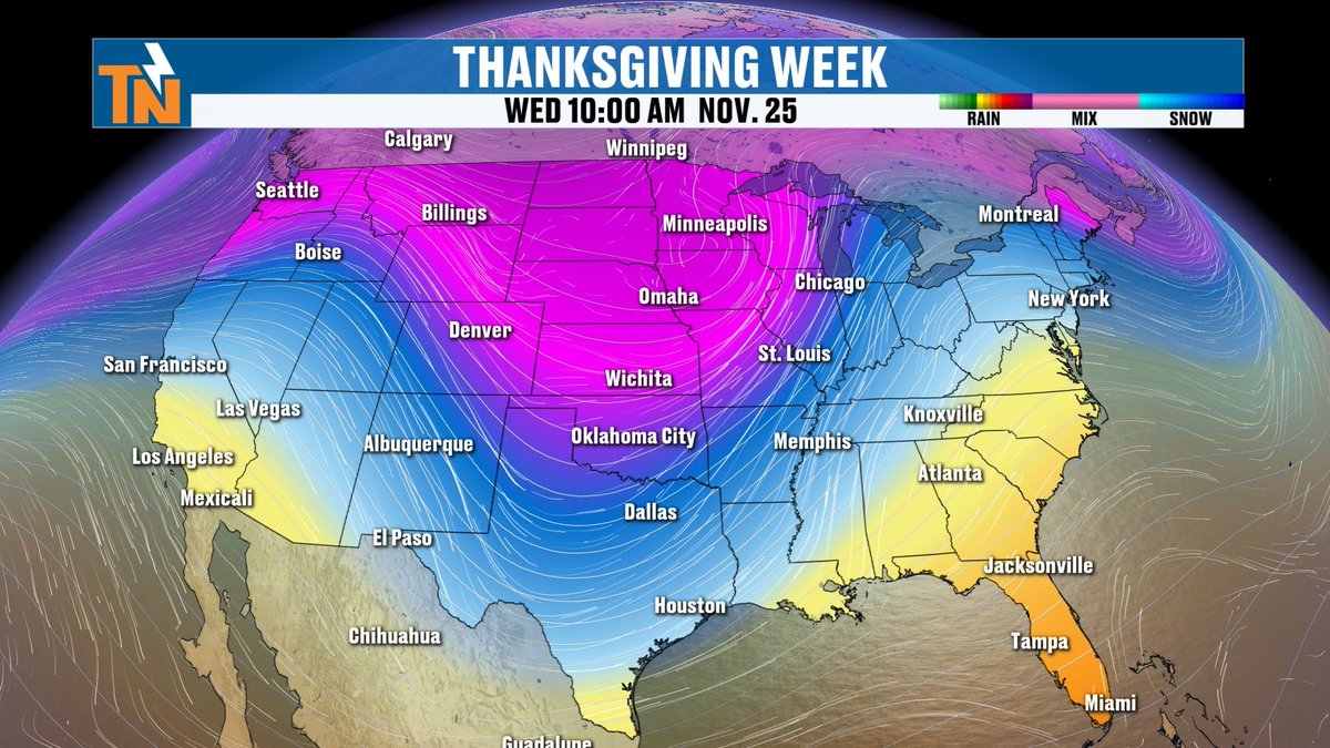
Looking ahead to Thanksgiving week. On this long-range view from Friday the 27th into Sunday the 29th, a big, deep low pressure system digs over the middle of the country and pulls a pocket of colder air down with it. It's still more than a week out, so the details will change. I'll keep tracking it and adjust the forecast as we get closer, but it's something to keep an eye on if you're traveling for the holiday.
@volunteerhomemortgage
You need a guide to lead you through the mortgage process so you can focus on finding the home you've been waiting for.
Here's the 7-day, and it's a warm one.
The average high this time of year is 59, and we're running 5 to 8 degrees above that: 64 today, 66 Thursday, then 67 Friday, Saturday and Sunday.
A cold front brings clouds this weekend and a 20 percent chance of light showers Sunday and Monday, with highs easing to 62 Monday and 58 Tuesday.
Overnight lows climb from the 30s tonight to the mid to upper 40s by the weekend. Sunshine, no rain and warm afternoons through Saturday.
Heading over the river and through the woods this holiday season? Make sure your vehicle is road-trip ready! Visit Quick Lane Tire & Auto Center at @rayvarnerford in Clinton. Learn more today!
Rain chances are small for the next week. It's 0 percent Wednesday through Saturday, then just a 20 percent chance Sunday and Monday as the front moves through, and back to 0 percent Tuesday. The Sunday evening rainfall map shows the heavier rain staying along the Carolina coast and out in the central Plains, with East Tennessee mostly dry. Not a washout by any stretch.
@tnstandard is locally owned and operated by Kelton Balka, a fifth generation master plumber. He is a big believer in taking care of his customers which is why Tennessee Standard has thousands of five star reviews. If you’ve got an annoying plumbing issue, give him a call or book online on his website, https://t.co/0D0cI3BOgc, he’d love to help you out.
The big-picture setup for the next few days. High pressure is parked over the Southeast, and by Friday afternoon it's sitting right off the coast, pumping in warmer air. Out west, a deeper trough and a couple of low pressure centers are lining up, and the one near Florida will try to form a coastal low. By Sunday morning two storm systems, one along a cold front over the Plains and one off the Southeast coast, start to converge. The takeaway for us: dry and warm through the weekend, and an active pattern building for next week.
@MonsterTreeServiceofKnoxville
Fall is the perfect time to address potential hazards before winter arrives and to plan for healthy growth when spring returns.
Don't wait until a storm creates an emergency. Let Monster Tree Service of Knoxville help you identify problems early and keep your trees safe, healthy, and beautiful throughout every season. 865-985-0881
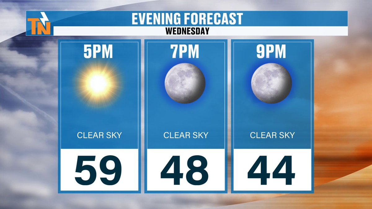
Mild afternoon on the way. Highs reach the low to mid 60s: Knoxville 64, Chattanooga 65, Tri-Cities 66, and a few spots near Pigeon Forge and Newport touch 67 to 69. Winds are light, gusts only 10 to 16 mph from the north and northeast. If you've got evening plans, it cools off quickly after sunset: 59 at 5 PM, 48 at 7 PM and 44 by 9 PM. Grab a jacket for tonight.
* MEDIC is the primary blood product provider for 24 hospitals and emergency air and ground transport services across 23 counties in East Tennessee and Southeast Kentucky.
* 1 in 7 of us will need a blood transfusion in our lifetime.
* Only 3% of eligible donors donate blood products.
•The shelf life for red blood cells is 42 days. The shelf-life for platelets is 5-7 days.
@medicblood
Here's why it's so quiet.
On water vapor, the orange and brown shading is dry air, and it's sitting right over Tennessee and the Southeast.
The moisture is way out west, where a Pacific storm is pounding the coast with rain and heavy snow in the Cascades and Sierra Nevada.
There's also a little kink in the flow near Florida, which is the next low trying to spin up. Plenty of weather out there, but none of it is headed our way today.
Improving the lives of the people we serve The @mcnabbcenter is the region’s leading nonprofit provider of mental health, substance use, social and victim services. We provide a quality and compassionate approach to care from infancy through adulthood.
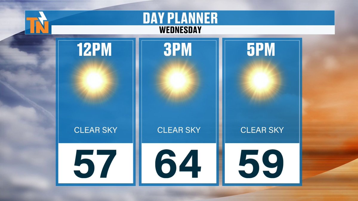
Another frosty start across East Tennessee, though it's a bit milder than yesterday. Knoxville and the Tri-Cities are sitting at 34 this hour, Chattanooga 36, Crossville 36 and Jamestown 37. Some spots dipped into the upper 20s earlier, including 28 in LaFollette and 27 in Athens, so a hard freeze happened in a few places. Most of us are running 1 to 6 degrees warmer than this time yesterday. Today is a clear-sky day all the way through: 57 at noon, 64 by 3 PM and 59 at 5 PM. Enjoy the sunshine.
@MasterbatteryKnoxvilleTN
Master Battery serving Knox and surrounding communities for over 40 years. We now offer mobile installation services that allow us to come to you when battery has failed. We have what you need when you need it. Master Battery is the home of the best price, Guaranteed! So why pay more when you don’t have to.
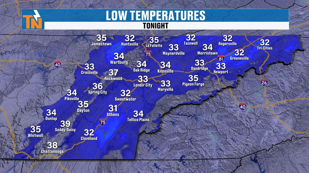
Tonight stays clear and gets cool in a hurry. 58 at 5, 50 at 7 and 44 by 9. Lows end up in the 30s again, with Knoxville around 34, Athens near 31 and Chattanooga around 38. A little frost is possible and fog may return, so give yourself some extra time in the morning.
@KnoxMission@KARMStores
Knox Area Rescue Ministries is a Christ-centered nonprofit dedicated to serving the homeless and vulnerable in the Knoxville area. Through shelter, meals, recovery programs, and supportive services, KARM works to restore lives with compassion, dignity, and hope.
Looking at Sunday night, the GFS and the European both keep most of the rain off to our south and east. The GFS has a little over along the Carolina coast and the European is even quieter. The rain outlook through Monday agrees: about a quarter inch near Raleigh and Norfolk, around three quarters of an inch at Myrtle Beach and Charleston, and basically nothing for us.
Locally owned and operated, AA Air with @centralcityhvac. Serving the greater Roane County and Knoxville Metro area, keeping you in your Comfortable Zone for over fifty years… visit your comfortable zone (dot) com or call 865-213-1354
Central City Heating and Air Conditioning; keeping you in your Comfortable Zone for over fifty years @aaaircompany.
Two things I'm watching for the holiday stretch.
The rain forecast through December 1 builds heavy totals along the Southeast coast and up the East Coast.
And the snowfall outlook for Sunday the 29th shows snow across the Rockies, the northern Plains and into the Northeast.
That is guidance, not a forecast, and it will change, but it's worth watching if you're traveling.
At @burks&ogle we’ve built a reputation for delivering strong outcomes. Our attorneys combine experience, focus, and a personal approach to every case we take.
We make sure you understand your options from the start. Then we help you build a clear, proactive strategy designed to win.
Here's the loop for Thanksgiving week. The trough digs into the Plains on Tuesday, deepens through Wednesday and settles over the middle of the country by Thanksgiving Day, with cold air getting pulled in behind it. How far east it goes will decide our weather for the holiday.
@MonsterTreeServiceofKnoxville
At Monster Tree Service of Knoxville, tree care is about more than simply cutting branches. Our team includes two ISA Certified Arborists who have the knowledge and experience to evaluate your trees and recommend the right care. Whether your trees need pruning, removal, disease or insect treatment, or simply a professional assessment, having the right advice can help protect your property and keep your trees healthy
Thanksgiving week is where it gets more interesting. On Monday a trough sits back out west. By Wednesday morning it has pushed into the Plains, and by Friday evening a deep trough is carving through the middle of the country. That could mean more rain chances for us around Thanksgiving, but it's still a week out, so I'll keep tracking it.
@amelsecpa is a public accounting firm that serves businesses and individuals with Tax, Accounting/Bookkeeping, and Consulting needs. Our job is to make your job easier!