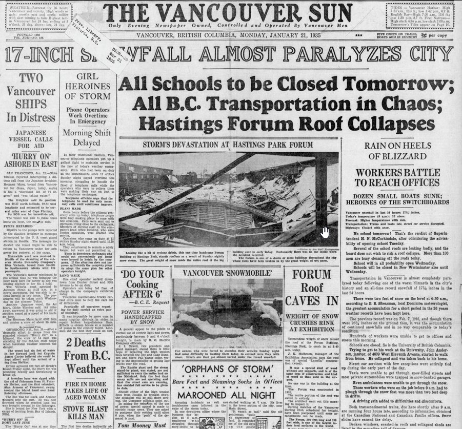
@MikeSmythNews@GlobalBC How about this one Mike? My Dad originally told me about it...he was 9.
-17C for a low temp Jan 19, 1935.
~45 cm of snow fell Jan 20/35.
Followed by 200-300 mm of rain later on the 20th through the next several days. 😮@GlobalBC@richardzussman
The flash flood in Nepal was caused by global warming. The portion of a glacier detached, sending a massive ice and rock avalanche into the Lhende Khola river, causing a high-velocity surge of ice and mud downstream.
BC could also be at risk. https://t.co/YtZq0HEJWv via @YouTube
Posting this to give you an idea of how uncommon Thunderstorms are for the entire West Coast of North America due to the Marine influence of the Ocean.
For Vancouver, BC we average only 6 Thunderstorms per year. Usually those 6 are very weak, very short lived counting down to mere minutes, and only impact a very localized area.
What we saw yesterday around our area was an MCS Thunderstorm Outbreak. A Mesoscale Convective System. A term that has no business being anywhere within 400km of Vancouver, BC normally. Seriously, we hadn't seen one in over 29 years before yesterday.
What it means, is that it is not a Supercell Thunderstorm. But it is a group of Thunderstorm Clouds that organize into what you saw last night. It was made up of numerous seperate Thunderstorm cells within its complex. Each cell would blow up into a Thunderstorm, spark 10-20 Lightning Bolts, then dissipate. But remember that it was organized. Once over the Strait, as one Thunderstorm would die out, another would blow up right beside it, and so on and so on over an area of over 100km in a straight line.
The factors that allowed it:
1. Extreme Instability for our area
2. Exceptionally high humidity
3. Abnormally high Convective Available Potential Energy
4. Daytime Heating
5. Warm Ocean Water in the Strait
6. Monsoonal Moisture feeding into the low
7. A negatively tilted Upper Level Low sliding in
8. Very cold air aloft
9. The Mountains acting as a guide to keep the Storms locked over the Strait
10. Earlier Thunderstorms feeding into the Instability
11. Abundant Thunderstorms along VI and S2S regions as the setup reached the Strait
12. A long open stretch of water from Comox to Tsawwassen Available for the MCS setup
See where I am going with this? This was not a run of the mill setup for Thunderstorms yesterday and early this morning. As soon as all those steps came together to prime a Severe Thunderstorm outbreak. As the main energy of the Storms hit the Strait, the incoming and slow moving Upper Level Low lit the match, then Boom!
I believe this has a return period of once every 20-30 years for our area. Super, super rare weather event to see for this area. The conditions and result are at the absolute peak of what is Geographically Possible for our area. We may never see something like this again for our area.
An MCS is something you see on the Prairies in Canada, or along the Plains and Southern States of the USA. To see one occur in Vancouver, BC, is downright shocking to the Weather community.
Severe Thunderstorms Warnings are almost non-existent in the Lower Mainland of BC as a whole. We can go years without seeing one issued for our area. But for Richmond/YVR we can go decades without seeing one issued. That's how truly insane this was... #bcstorm
In a league of its own!
When you see me post about Monster El Nino’s it probably sounds like I’m hyping. I get it. So I put this visual together so you could see just how deviant this year’s is expected to be. The white line is the forecast for this year. The other colored lines are the strongest El Nino’s on record.
That’s why I say it’s in a league of its own. In the 175 years we have data for, this event looks to be, possibly by far, the strongest. Time will tell, but it has reached Super status several weeks earlier than any other event. In a nutshell, El Niño releases tremendous heat into the atmosphere that’s been stored in the deep Western Pacific Ocean for years. That excess heat released throws weather patterns off-kilter and, on top of Earth’s established warming trend, raises global temperatures to previously unseen levels. #ElNino
Thanks @hausfath for your great ClimateBrink dashboard!
It’s VERY smoky in Osoyoos, BC right now, with smoke from the Kaiser Canyon fire blowing up from Washington State. If you won’t manage your forests to prevent these fires there’s no telling what we’ll do. *see how stupid that sounds?
A #firesmoke filled start to the morning in #Kamloops as the wildfire situation in the Fraser Canyon seemingly gets worse, with a new fire on the east side of the #Fraser growing dramatically. More smokey conditions to continue today.
Story Here --> https://t.co/rPnqVSgGSl
@kevole Kevin - I have loved listening to you and the team every weekday morning at 330 am,
driving into my work at Global TV. You are my start to each day and it has been my tradition. So enjoyable and informative!!
Thinking of you and the other tremendous people on this lousy day
Loved this guy. Was my first ever colour commentator on @blazerhockey hockey broadcasts on @RadioNLNews to start the 1984-85 season. It didn't take Moorsey long to realize a much better gig was coaching the Vernon Lakers. In the words of Don Cherry "He's a Beauty"
Mark @MMadryga up on the Global BC rooftop doing the weather segment! Putting his rain hat to use! Oh and having it blow away! Always interesting segments on the roof, eh!
Jennifer @JenPalmaGlobal & Sonia @SoniaSunger staying dry in the studio! 🙂
That time a Kamloops boy and a PG boy spent some quality time with Canada’s Greatest Athlete! Can’t begin to tell you what a thrill it was to be beside Gene Kiniski…just never know what you’ll find in @GlobalBC archives!
I am indifferent to the Vancouver #Canucks having watched from a distance for years - but, if there is a hockey God, please let them have the first overall pick in tomorrow's NHL Draft. This city needs it.