Friday April 3 8:30 pm: Severe Thunderstorm Warning that includes Moore. Storms are due west moving towards us, storms have previously been tornado-warned. Moore EOC is activated.
5pm Tue 3/10. Tornado Watch now in effect including the City of Moore, thru 11pm. Primary threats in the large watch area include a few tornadoes, widespread damaging winds, widespread large hail.
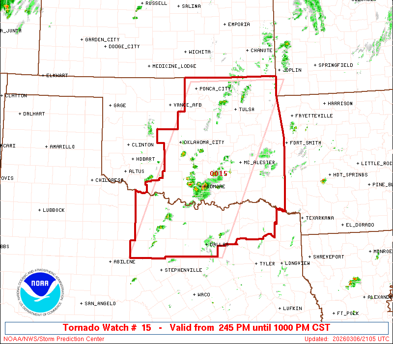
Fri 3/6: Tornado Watch issued including Moore. Primary threats include...a few tornadoes/couple of intense tornadoes; scattered large hail to 2.5 inches; scattered wind gusts to 70 mph. Severe thunderstorms including supercells expected to develop mid/late afternoon
Tuesday 7/8 10:10 pm: A Severe Thunderstorm Warning has been issued including Moore. Hazards are for 60 mph wind gusts, quarter sized hail, and lightning.
Wed 6/18, 5:50 am: A Severe Thunderstorm Warning has been issued that includes Moore; threat is for quarter-sized hail. Storm core is just south of Minco, moving east at 35 mph. There are a couple of other cores in the line of thunderstorms which may also produce some hail.
Tuesday 6/17 11:35 pm: Storms thankfully stayed north of Moore... EOC will be standing down for now. Additional storms likely later, maybe towards daybreak.
Tuesday 6/17 9:30 pm: Moore is now in a Severe Thunderstorm Watch until 4 am. Primary threats include widespread damaging winds and isolated significant gusts to 85 mph, scattered large hail, and tornado or two possible
Sunday June 8th 8:50 pm. Storms have moved through, no damage reported in Moore. Our citizen volunteer storm spotters have been released; the Emergency Operations Center will be demobilizing from weather monitoring operations. Everyone have a good night! Thunder UP!
Sunday June 8th 8:50 pm. Storms have moved through, no damage reported in Moore. Our citizen volunteer storm spotters have been released; the Emergency Operations Center will be demobilizing from weather monitoring operations. Everyone have a good night! Thunder UP!
Confused? Here's the easy part: Keep an ear out on your methods of receiving weather alerts; have a plan to shelter if a thunderstorm approaches. "Severe" means the potential for winds of around 60 mph or greater, or 1" hail or bigger, always includes potential for a tornado.
Sunday 6/8 5:15 pm. A Severe Thunderstorm Watch has been extended area-wise to include Moore and Cleveland County. This is NOT the PDS/Severe Watch that is still for southwest Oklahoma, this is an extension of the farther north "regular" Severe Watch.
Friday June 6 10 pm: Tornado Watch including Moore. Expect severe storms overnight!
NOTE!! The Weather Radio system is having issues!! NWS is working on issue, but the radios may not be working to warn you overnight tonight! Have alternate means to receive alerts tonight!!!
Tuesday June 3 - 2:15 pm: A Severe Thunderstorm WATCH for much of Oklahoma, including Moore. Primary threats include...Scattered wind gusts/70 mph, scattered large hail events to 2", and possibly a tornado or two are possible. The Watch is in effect until 9 pm.
Plan to have an alternate method of receiving weather warnings Tuesday-Thursday of this week, as the NOAA Weather Radio system will be down during computer updates