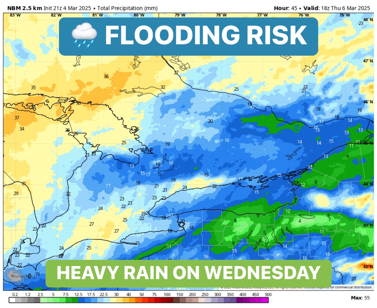
#ONStorm#ONwx ⚠️ FLOODING RISK ON WEDNESDAY
Heads up, Southern Ontario! Milder temperatures are on the way, along with heavy rain on Wednesday, which could lead to flooding in flood-prone areas.
With an already excessive snowpack from this winter, the added rainfall will only increase the risk of localized flooding. We’re looking at between 15-30mm of rainfall accumulation with locally higher totals in regions that see thunderstorm activity.
Some areas could even see daytime highs in the double digits, accelerating the snowmelt and making the situation worse.
On top of that, thunderstorms are possible in both the morning and evening. While they *should* remain non-severe, there is a marginal severe risk just south of the border, including a very low chance of a tornado. The colder waters of Lake Erie should help weaken any storms before they reach us, but we’ll be keeping a close eye on things just in case.
Don’t get too comfortable with the warmth! A return to below-freezing temperatures is expected by Thursday morning, with rain changing to wet flurries as the system moves out. Some areas could even pick up a few centimeters of snow.
Stay tuned for updates!
- Brennen
#ONStorm#ONwx GET YOUR STORM CHIPS! ❄️
If you've been part of our community for a while, you might remember our 'storm chips' forecast from a few years back. Well, with a major winter storm on the way in the next few days, we thought it was the perfect time to bring it back!
For those heading out tonight to stock up before the snow starts flying, we’ve got you covered with our highly scientific recommendations on how many bags of storm chips and drinks you should grab. Of course, these are just friendly suggestions—there’s no harm in sneaking a few extra into your cart, especially with another potential winter storm on the horizon this weekend.
We know this is a fun and lighthearted forecast, but don’t worry—our full, in-depth storm breakdown is coming later today. We’re just waiting on some additional model data this afternoon before finalizing the maps. Stay tuned!
- Brennen
We’d like to clear up some confusion regarding the ongoing heatwave across Ontario and much of the Eastern United States and Canada.
Some have taken issue with the use of red in temperature maps, claiming it’s intentionally done to instil fear in the public and push an agenda based on what is 'normal summer weather.'
A few points on this:
- It isn’t summer yet—the summer solstice doesn’t occur until this Thursday, so we are still technically in late spring.
- The average high temperature for this time of year in Ontario is around 23 to 25°C. This means the current temperatures are approximately 10°C or more above average. This is certainly not 'normal' for this time of year.
- Extreme heat can pose a serious threat to vulnerable populations, including the elderly, the unhoused, and people with certain medical conditions—not to mention our furry friends. The risk of heat stroke increases significantly as temperatures rise above 30°C. Heat events frequently cause deaths, including over 600 people in British Columbia in 2021.
- The hottest temperature ever recorded in Ontario was 42.2°C in Fort Frances on July 13, 1936. Meaning that we are only a few degrees below the all-time heat record in Ontario.
- We use a straightforward colour scale with colder colours (dark blue, blue, green, etc.) for colder temperatures and warmer colours (yellow, orange, red, light purple) for warmer temperatures. Since we are seeing temperatures in the mid-30s, it makes sense that our map would use dark reds, as it doesn’t get much warmer than that.
Our only agenda is to accurately and clearly report on the weather. Manipulating the colour scale to keep a group of people happy would itself be pushing an agenda by intentionally downplaying this heatwave, which goes against our values as a weather organization firmly rooted in science.
At the end of the day, you can interpret the data however you like. You know yourself and your family best. If you don’t feel that these temperatures are 'extreme,' you are welcome to ignore it and keep scrolling. We are here to provide information and help keep people informed about significant weather.
- Brennen
We are elated to be at @YRDSB_skills at Humber College today and participating in the #LandscapeDesign competition! What a great way to apply a new skill! Way to go, @MillikenMHS !
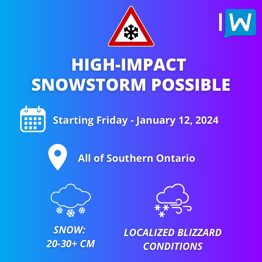
#ONStorm#ONwx ⚠️ Get Your Shovels, Southern Ontario! The First Major Snowstorm of the Season Is on the Way This Weekend ❄️
📅 Friday, January 12 - Sunday, January 14, 2024
🔗 https://t.co/iceSWJ78nQ
——
Confidence is growing in a strong system set to sweep across Southern Ontario starting Friday and persisting throughout the weekend. In contrast to previous weather systems, this one looks likely to keep most of the region on the snowy side, leading to widespread and substantial snowfall.
Although there's always a chance for last-minute changes, it's nearly certain that parts of Southern Ontario are in for a heavy snowfall this weekend. The onset is expected sometime Friday afternoon, continuing into Saturday.
We're still finalizing the exact details, but a more detailed preliminary forecast will be available later today.
Currently, we anticipate general snowfall totals in the range of 20-30cm across a broad area of Southern Ontario, extending from the Southwest through the Greater Toronto Area and into Central/Eastern Ontario.
Almost everyone in these regions should brace for significant snowfall. In some localities, particularly around Lake Huron and Georgian Bay, totals could surpass 30cm, boosted by lake-enhanced snowfall.
The combination of intense snow and potentially strong, damaging wind gusts of 70-90km/h could lead to complete whiteouts. We can't discount the possibility of blizzard conditions, especially in Southwestern Ontario.
The main area of uncertainty lies along the Lake Ontario shoreline and in the Niagara region. Some forecasts suggest a brief switch to rain overnight on Friday, followed by a return to snow on Saturday.
This could result in lower snowfall amounts near the shoreline, heavily dependent on the storm's exact path. The latest data shows a trend towards a westward path, which could introduce warmer air into the region.
Another aspect we're watching closely is the potential for significant lake effect snow following the storm, starting Sunday and possibly extending into the week. This could lead to remarkable snowfall accumulations in typical snowbelt areas such as Grey-Bruce, Simcoe County, Muskoka, and Parry Sound.
By week's end, some of these areas might be measuring the snow in FEET (1 ft = 30cm).
In summary, the upcoming week promises to be a hectic one, but we're prepared and will keep you updated with in-depth information around the clock. Stay tuned!
- Brennen
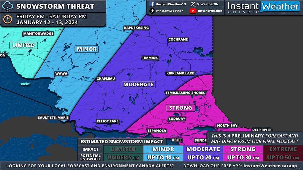
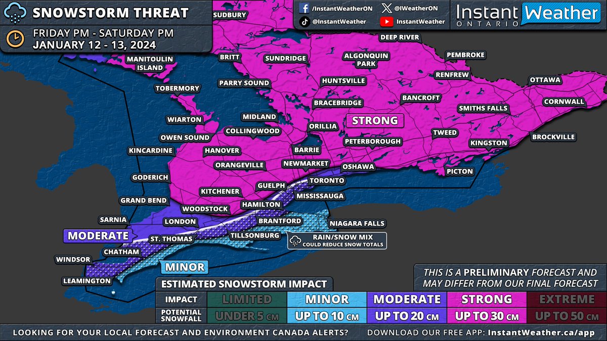
#ONStorm#ONwx ❄️ SNOWSTORM PREVIEW: Widespread Significant Snowfall of Up to 30cm on the Way for Most of Southern & Northeastern Ontario
📅 Friday, January 12 - Saturday, January 13, 2024
——
After reviewing the latest model data from this evening, it appears increasingly likely that Southern Ontario will experience its first widespread significant snowstorm of the season starting Friday.
We'll publish a detailed forecast article in the morning. For now, here's an early look at the forecast maps based on this evening's model runs. Remember, this forecast is preliminary, as the storm is still about 36 hours away. Although there's time for model adjustments, any changes should be minor given the high confidence in this event.
Before Friday's main event, a weaker system will pass through Southern Ontario on Thursday morning and afternoon. While significant accumulation isn't expected, a few centimetres may cover Central and Southwestern Ontario, including the Greater Toronto Area. Lake enhancement east of Lake Huron could increase totals to 3-6cm in the Owen Sound to London corridor, tapering off by late afternoon.
The main storm is expected to start between 2-5 PM on Friday, beginning in Extreme Southwestern Ontario. Initial bands could bring heavy snowfall, with rates of 5-10cm per hour, and the potential for thundersnow, a phenomenon we haven't seen since last winter's major blizzard. ⚡️
Strong wind gusts of 60-80km/h, locally reaching up to 90km/h, will likely create treacherous driving conditions. Areas might experience localized blizzard conditions, especially in Southwestern Ontario, the Golden Horseshoe, and parts of Central Ontario.
These heavy snowfall rates will move through Southwestern Ontario, affecting London, Kitchener, and Hamilton by early evening. The Greater Toronto Area will experience this intense snow later in the evening, eventually spreading northeast to Central and Eastern Ontario, continuing overnight into early Saturday.
While the heaviest snowfall will be brief, moderate snow will persist behind the initial band throughout the night into Saturday. Around the Lake Ontario and Erie shorelines, a brief surge of warmer air Friday night into Saturday morning could lead to a temporary changeover to rain, potentially reducing snowfall totals in the Niagara region and parts of the Greater Toronto Area near the lakeshore.
A sharp cooldown early Saturday morning will bring temperatures back below freezing, switching precipitation back to snow and creating a risk of flash freezing. Icy road conditions are likely on Saturday morning.
By Saturday's end, most of Southern Ontario, excluding Deep Southwestern Ontario and the Niagara region, can expect 15-30cm of snow. The Lake Erie shoreline and Niagara region are projected to receive 5-15cm, while the Greater Toronto Area could see 10-20cm, with higher amounts further from the lakes.
This event will also affect Northeastern Ontario with over 20cm of snow on tap for Sudbury, North Bay and Temiskaming Shores starting late Friday evening and continuing through Saturday.
As the system exits, lake effect snow will intensify late Saturday around Lake Huron and Georgian Bay, with snow squalls likely into next week. This could result in substantial snowfall over the week in areas like Goderich, Kincardine, Hanover, Owen Sound, Wiarton, Barrie, Orillia, Midland, Bracebridge, Huntsville, Parry Sound, Britt and Sundridge
We'll provide more details in our full forecast article on Thursday morning and a final forecast with precise totals either Thursday evening or Friday morning.
- Brennen
🤖 Educating students about AI tools can help prevent their misuse more than banning them outright. Check out 7 questions about AI that *every* student should be able to answer: https://t.co/EUi7KsycWA
From tlnwilkinson on X: Stealing awesome ideas like this is the best part of social media. Best morning work ever!!
Would you try this in your classroom? 🤔
Let's play the "never have" game. Never have Timmins, Sudbury, and North Bay experienced a white #Thanksgiving. Since 1955, no record of snowfall accumulation on Thanksgiving before. But, that could change this year. It’s been snow-free in Kapuskasing since 1987. #ONwx#ONsnow
Sad news: Jamboard is disappearing.
Good news: FigJam (https://t.co/yH2jiuwk2G) is a great alternative.
Better news: You can port Jamboard files to FigJam. 🎉
Best news: FigJam has features we wish Jamboard had (but never did). 😆
More: https://t.co/tLGywLZIol #sponsored#ad
Not today planned obsolescence! Our LED TV died suddenly after doing a weird flashing thing. So, instead of buying a whole new one, a bit of research and some very basic repairs, I replaced the LED light bars and it back to working order. 50$ compared to 600$ for a new TV.
"Add << >> to a textbox in the upper right hand corner to display the time, including seconds, while presenting your Google Slides."
https://t.co/6U9zPRjzqi @claycodes
#ONStorm#ONwx 🍂 FALL COLOUR UPDATE: Leaves Beginning to Change in the Eastern GTA and Dundalk Highlands
📅 Sunday, September 3, 2023
Read our update for the latest details ⬇️
https://t.co/pf2H3j07GU