@AlbertWhitefie5@Sanderzk@WASSP_global Naast dat alleen WASSP Backscatter heeft (bodem hardheid indicatie), zie hier het verschil in resolutie tussen de twee systemen.
De DFF3 is overigens een prima apparaat en maakt Multibeam Echosounder technologie nu ook beschikbaar voor hobby/sportvisserij.
@Sanderzk@AlbertWhitefie5@WASSP_global Volgens mij zit er wel een soort eenvoudige stabilisatie op, maar denk niet dat dit voldoende is als je met een beetje golven op open zee vaart.
Dit Furuno systeem is gemaakt voor de sportvisserij en de WASSP met z'n eigen Motion Sensor is meer voor professioneel gebruik.
WASSP Multibeam Echosounder in TimeZero with 3D Backscatter mapping of the seafloor indicating hardness of the bottom to identify rocks, sand, mud, etc.
The perfect tool for professional fishing operations.
@AlbertWhitefie5@Sanderzk@WASSP_global De DFF3 van Furuno heeft geen 'Backscatter' om de hardheid van de bodem te laten zien (om bv stenen, zand, etc. van elkaar te onderscheiden). WASSP heeft dit wel. Verder is de resolutie van de WASSP vele malen hoger dan die van de Furuno, dus veel meer detail en nauwkeuriger.
Using WASSP Multibeam Sonar, Oceanography students from the University of Rhode Island have been able to profile ripples on an estuary floor up to 15cm in distance apart.
Mega Yachts Exploring Uncharted or Poorly Charted areas can Map the Seafloor for safe passage using WASSP Multibeam Sonar on the Tender.
Mapped data is transferred in real-time from the Tender to the Yacht.
Come see us at the Monaco Yacht Show 2019
Stand DS62 - Darse Sud- Furuno
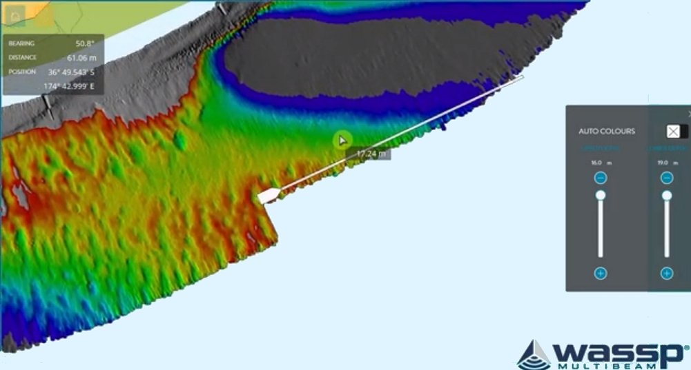
Introducing the new WASSP CDX software V4 with a number of new improvements such as a new Multi-resolution Database with automatic depth-adjusted, best resolution mapping which can be used at all depths and can be uploaded to existing databases.
See: https://t.co/cjhRWTjpDm
Rhein-Neckar Port Authority of Mannheim (Germany) have installed a WASSP S3i Multibeam Sonar on its survey vessel M/V Rheinau to map the estuary areas of the Mannheim port in the river Rhine. Results provide highly accurate data of the current depth conditions in the port.
Wireless WASSP Multibeam Sonar for remote seafloor mapping on display at METSTRADE 2018. Mega Yachts are now able to expore and map uncharted, or poorly charted areas.
Visit WASSP at Stand 10.404 in the Super Yacht Pavilion. #Metstrade#yachting#3dmapping
Maritime mysteries -- old and new -- come to life in #DraintheOceans, combining scientific data and digital re-creations to reveal shipwrecks, treasures, and sunken cities on the bottom of lakes, seas and oceans around the world. https://t.co/XOtnFQYwle
WASSP MULTIBEAM SONAR IN AQUACULTURE
WASSP Multibeam Sonar can be used in aquaculture to explore and map the seafloor of any area where a fish farm is planned and once the farms are built, it can be used to create a 3D map of the nets, anchorage cables and fish concentrations.