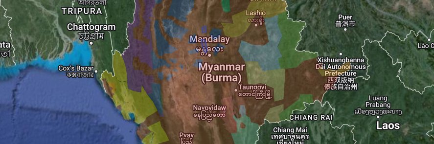
A Google Map of the Myanmar Civil War, created largely to support my own understanding of the conflict. Sharing in case it's useful for others. This is a work in progress and I can't guarantee 100% accuracy, but updating and improving whenever I get time
https://t.co/Yw5KhgydMY
@MyanmarWarMap If you want to see the reality in myanmar and new map updates, then follow me. In a couple of days i Update the map. Everything that applied to the old Manager, applies to me. I will make my best to succed his account. https://t.co/k4aftcGZtt
Handing over the project didn't work out last time. So, this time I'll allow forks and see if competition works better. Here is a .kmz for the map. Comment here with links to any new spaces/products you create so that interested people can find you.
https://t.co/d07O5kmFRV
The grinding realities of life in a rapidly declining Western European economy have started catching up with me. Coupled with a severely disabled son and an inopportune parcity of inherited capital accumulation, ancilliary occupation has become an unfortunate prerequisite of that most welcome comfort, a roof over one's head. Ergo, nullum tempus ludendi. Cheerio :)
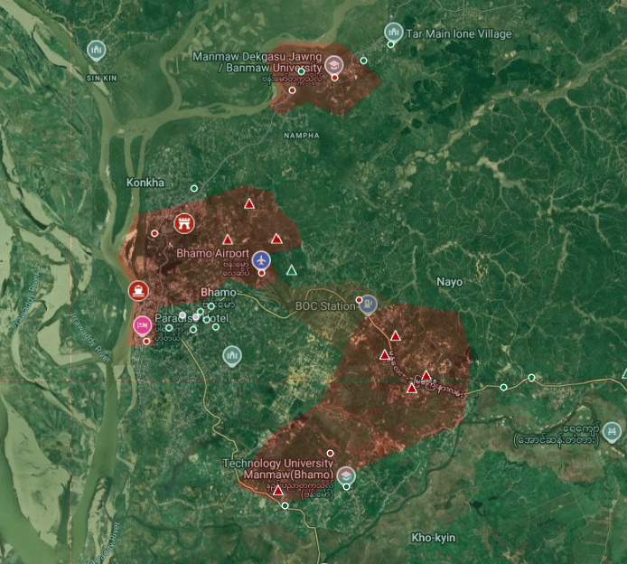
The reinforcements that arrived by river in early August shifted the tide of the battle, but they have been unable to break the siege. The airport remains contested, limiting a potential avenue of relief. And the forces near the University, Battalion 47 and the Support Battalions on the Bhamo-Momauk road remain cut off from the main force at the MOC-21 HQ in the city centre.
Receding river waters during the dry seasons will make further resupply missions more challenging, potentially allowing KIA to take the initiative again. However there are also rumours of China pressuring KIA to end the siege and reach a ceasefire agreement with the government.
Fighting continues on a daily basis in Bhamo, but there have been no major changes reported on the frontlines since September.
#Myanmar#Kachin
Map: https://t.co/PF8YK8jIm1
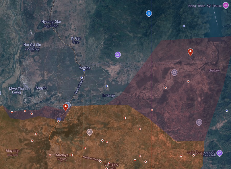
In Madaya township, overnment forces have recaptured the 1014 Air Defence Force Base and the adjacent Sedaw Gyi Dam. They have also captured Tangar Taung village and reports indicate PDF forces have withdrawn north of the Pai River.
#Myanmar#Mandalay
Map: https://t.co/PF8YK8jawt
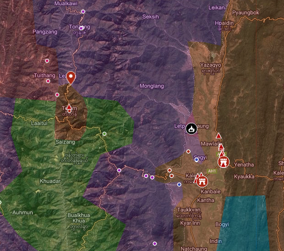
Another force is currently moving Tai Ngen from the Kale direction, meaning defenders face a two pronged attack aimed at reopening the Kale - Tedim road.
SAC forces have recaptured the base at Kennedy Peak, Chin State and are close to the key road intersection at Tai Ngen. This comes following the arrival of reinforcements by air at the Battalion 269 base in Tedim.
#Myanmar#Chin
Map: https://t.co/PF8YK8jawt
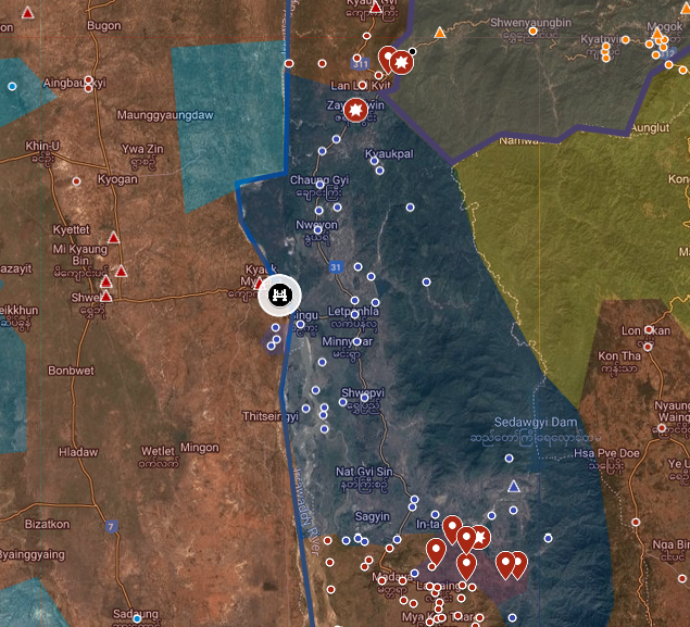
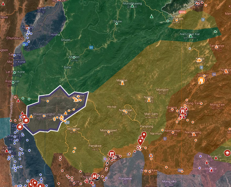
It's hard to predict with confidence, but war often comes down to numbers. If SAC can field the force like the one they used against TNLA, then I don't think PDFs can hold for long. But getting a force that big in place to attack Mogok won't be easy, given the current logistical situation. Focussing on Singu might make sense as a first priority.
There's also some question about the availability of forces. The units that fought TNLA will need some R&R, and there are several major theatres running right now so it's not clear how much serious combat power they have to spare.
TNLA signed a ceasfire agreement with the Military Council on Wednesday, ceding control of Mogok and Momeik. In response, Mandalay PDF and Mogok Strategic PDF have declared their intent to continue defending these terrories.
#Myanmar#Rakhine
https://t.co/ql9Qr53qGB
https://t.co/CReNi97vRG
https://t.co/WH0u0IVbRr
@Die_Steiner KIA are hard pressed right now, with ongoing SAC offensives in Bhamo, Hpakant, Waingmaraw and Khaunglanhpu. However, there is a separate brigade for the Shweli river area and I would be surprised if they don't offer some support to defend Mogok.
A Google Map of the Myanmar Civil War, created largely to support my own understanding of the conflict. Sharing in case it's useful for others. This is a work in progress and I can't guarantee 100% accuracy, but updating and improving whenever I get time
https://t.co/Yw5KhgydMY
@mightyonedeeps As much as possible. This is a part-time project for me and I don't have inside information. So updates can be delayed and I can't guarantee I will catch every change. But I do my best to keep it up to date and post significant changes of control.
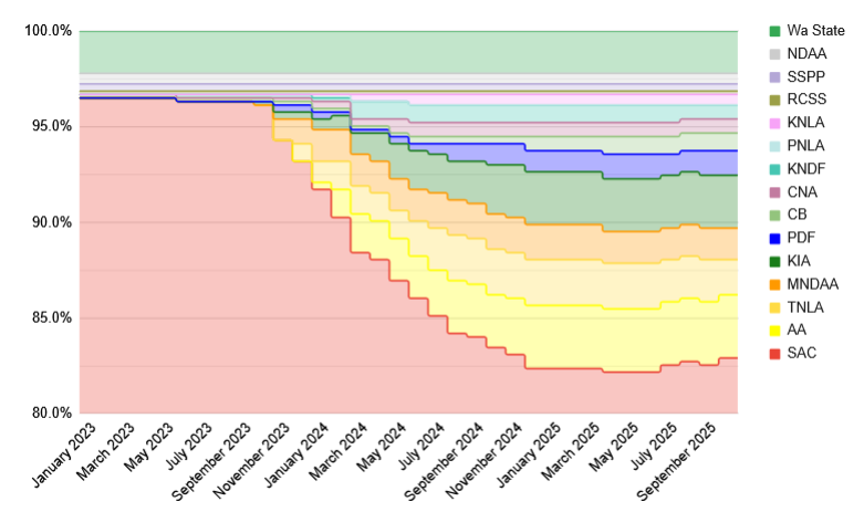
2025 has seen a marked reduction in changes of control. Rebel groups have captured just 3 major towns this year: Indaw, Falam and Banmauk. However SAC forces have retaken 6: Lashio, Demoso, Thabeikkyin, Nawnghkio, Kyaukme & Hsipaw.
The change in trend is not yet significant to show a full reversal, but it is clear that the momentum of rebel gains seen after the start of Operation 1027 has come to a halt in 2025.
The upcoming election period may see further shifts. Both sides have motivation to escalate in this period, seeking symbolic victories to demonstrate their power. This next phase will be critical, though likely not decisive for the ongoing civil war.
Rebel groups now control* 17.1% of major towns** in Myanmar, a slight reduction from a peak of 17.8% in April 2025.
#WhatsHappeninglnMyanmar
*control = majority control of the urban area
**major towns = main town of a township or subtownship administrative division
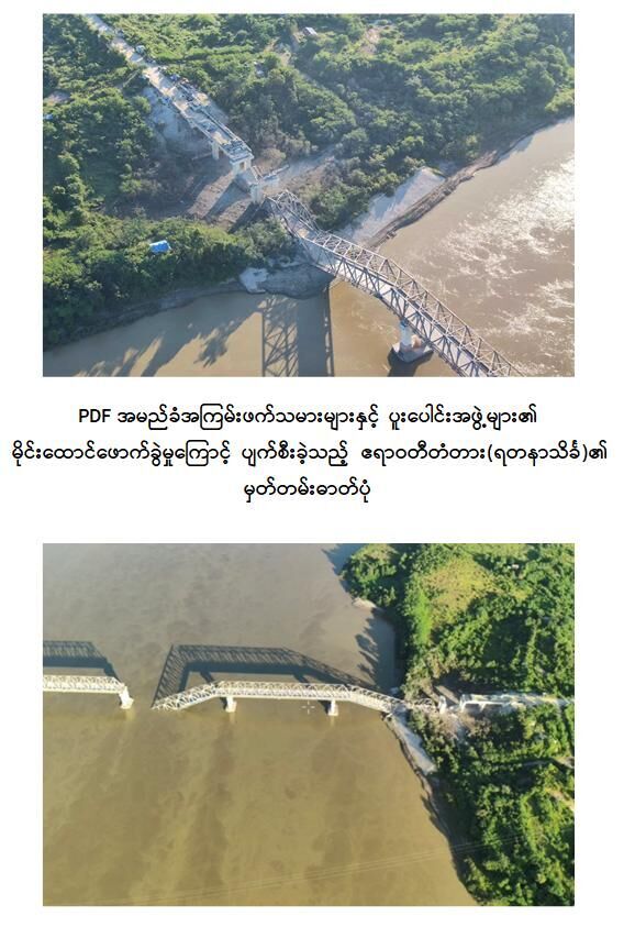
Images of the damage show that 2 non-consecutive spans have collapsed, in the centre and on the East side, making repair or erection of temporary spans difficult, if not impossible during combat conditions.
https://t.co/OZ4KUQJyPg
The Yadana Theinga Bridge between Shwebo and Singu townships has been destroyed. This follows an accumulation of government forces on the West bank near Kyauk Myaung and prevents the opening of a new front against Mandalay PDF.
#Myanmar#Mandalay
Map: https://t.co/PF8YK8jawt
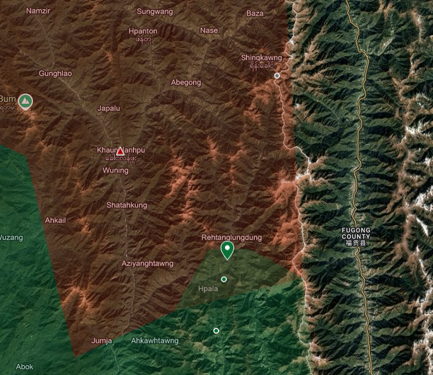
There are reports that the Tatmadaw has sent large numbers of reinforcements to Khaunglanhpu as they prepare their own offensive to retake Lar Chin, in Tsawlaw township.
KIA has captured 2 more small camps in Khaunglanhpu Township. The current offensive is heading up a valley towards Sheng Kawng village, near the border with China.
#Myanmar#Kachin
Map: https://t.co/PF8YK8jawt
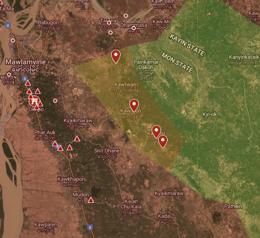
SAC forces have captured a series of villages in Kyaikmaraw Township, Mon State. News reports indicate there has been very limited resistance so far, with Revolutionary Mon groups retreating to nearby villages.
#Myanmar#Mon
Map: https://t.co/PF8YK8jawt
Reinforcements have reached Tedim, Chin State and are positioning along the Tedim - Tonzang road. There are also reports of major accumulation of forces in Kale, in preparation for a campaign in Chin State.
#Myanmar#Chin
Map: https://t.co/PF8YK8jIm1