⚠️ A Heads Up for Aviators: Widespread moderate & isolated severe turbulence forecast for the Central US. Affected areas include South, SE, & Midwest from 25k to 45k ft.
Fly safe! 🛫☁️ https://t.co/9KSwE7d5BT #aviation#weather#turbulence
Pilots near Denver/Central Rockies: high-based storms may produce VIRGA-related turbulence and strong downbursts through ~01–02Z.
Even if rain isn’t reaching the ground, evaporating precip can drive strong downdrafts. Avoid storms and monitor Convective SIGMETs. #aviationweather
Convective SIGMETs + multiple SEV turbulence PIREPs across TX/OK today.
TS hazards extend FAR beyond the heavy rain core:
⚠️ Severe turbulence
⚠️ Strong up/down drafts
⚠️ Wind shear
⚠️ Hail
“Threading the gap” between storms can become dangerous fast. https://t.co/9KSwE7d5BT
The AWC has officially added mountain wave turbulence to its turbulence product suite!
Following the April 30 launch, the first GAIRMET with the mountain wave tag was issued on May 4. This enhancement provides pilots & dispatchers with more precise data for safer flight planning.
Heads up: upgrade for https://t.co/F9eMGR93dw scheduled for next week includes changes to the altitude & time sliders plus several new features. Video summary: https://t.co/QR4HVUdlvl. Full list of changes: https://t.co/jCXK4QvrN7 #avgeeks#aviation
Coming soon: upgrades to https://t.co/F9eMGR93dw including range rings, data sampling w/ hover, color IR, and more! View the full list here: https://t.co/jCXK4QvrN7 #avgeeks#aviation
You asked, we listened. Coming soon: upgrades for https://t.co/F9eMGR93dw including custom range rings and data sampling on hover. View the full list here: https://t.co/jCXK4QvrN7 #avgeeks#aviation
Boston aviation impacts today:
Lowering ceilings (5–9 kft) + winds 30–40 kt near 10k ft may challenge aerial ops.
Light icing & minor turbulence possible, but not primary concerns.
Latest: https://t.co/7BEYiuU0PG #Boston#AviationWeather#MAwx
✈️ Flying in the Northeast today? Widespread aviation hazards are expected as low pressure moves up the coast.
Widespread IFR, low-level turb, and icing all forecast.
Check your route before you fly! 🌥️🧊🌬️ https://t.co/F9eMGR93dw
#AviationWeather#GeneralAviation#NortheastWX
Expect thunderstorms to develop this afternoon across much of the central US with storm tops quickly exceeding 40k ft. Icing, turbulence, IFR conditions all possible with these storms. Major airports likely to be impacted include KC, Chicago, and St Louis. #aviation
A strong Pacific storm moves into the north half of ZLC producing a large area of icing along with areas of rain, snow and low clouds. Also expect a few late afternoon and evening thunderstorms over ID-MT. 100kt jet stream will produce high level turb and mountain waves MT-WY.
When an aircraft flies through a cloud with temperature conditions that are just right, supercooled water droplets 💧can freeze on contact, ruining the aerodynamics of a plane ✈️.
Visit us at https://t.co/F9eMGR93dw for the latest Icing forecasts.
#pilotlife#AWC#FlightSafety
AWC issues #thunderstorm warnings that are meant for aircraft in flight. Those warnings are called convective SIGMETs. Here are some fun facts we found after analyzing 13+ years of those warnings. #aviation#avgeeks#science
And that's a wrap on this year's Convective Awareness Week!
Know before you go. Stay weather aware! Fly prepared!
Check https://t.co/F9eMGR93dw for your latest aviation warnings and forecasts.
For the latest on aviation convective hazards, head over to our website.
Our website, https://t.co/F9eMGR93dw, is your go-to resource for comprehensive aviation weather hazard information, including forecasts, outlooks, and warnings.
We created a super handy 1-page flyer all about thunderstorms and aviation. Get the facts on formation, hazards, and essential safety advice in one quick read.
Download this resource today at https://t.co/QlpRxUv8rD. Stay safe out there!
A strong storm system will develop over the central CONUS today with multiple aviation impacts expected. Check the latest forecasts and aviation hazards at https://t.co/9KSwE7d5BT before departure.
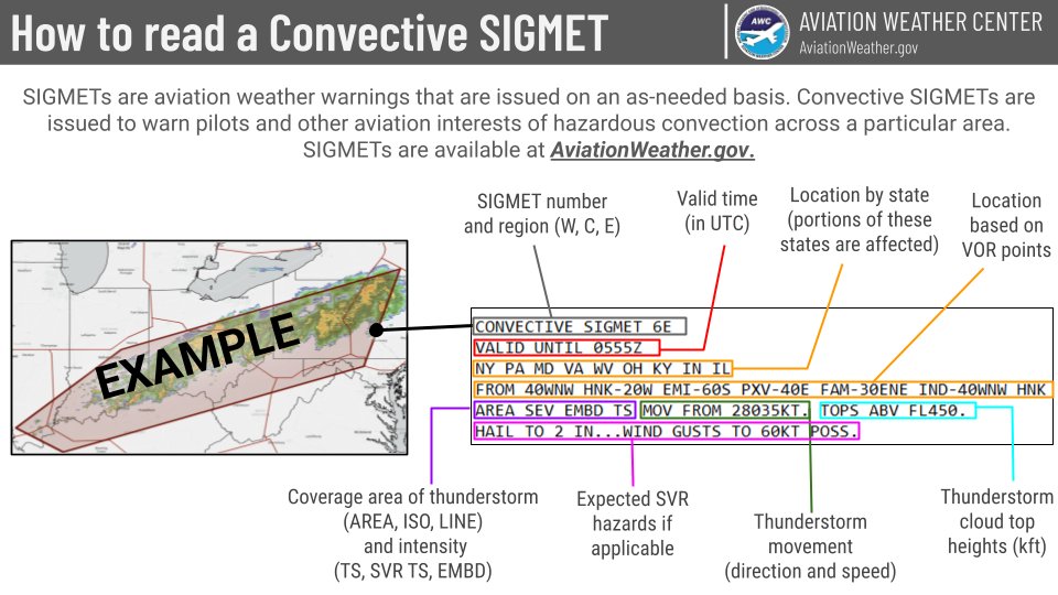
Ever wondered how to decode a Convective SIGMET?
Learn to identify:
- Valid Time
- Location
- Expected Hazards
- Cell Movement
- Cloud Top Heights
Stay safe and informed before you fly. Get real-time SIGMETs at https://t.co/F9eMGR9B34.
#AviationWeather#FlySafe#SIGMET
A cold front with an area of instability are resulting in areas of embedded T-storms. Afternoon convection will bring isol'd T-storms over central ZLC. Ample moisture brings icing, rain and snow showers, IFR conditions and mtn obscuration over many areas. #aviation