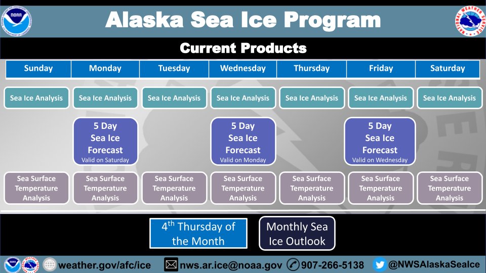
Hello! And welcome to the NWS Alaska Sea Ice Program (ASIP) Twitter page. Below you can find details on the sea ice products our team issues. Find more details on the ASIP website: https://t.co/qF02d2Hrl5
#ASIP
Yet another intense mid-latitude cyclone across the far NW Pacific this evening, seen via Himawari-9 RGB Air Mass imagery. The low is expected to steadily fill and weaken along the coast of the Kamchatka Peninsula over the next couple of days. #MarineWx
Late season arctic northerly winds brought the Bering Sea ice pack to it's maximum extent this season. The ice edge is 10-20 nm to the NE of St. Paul Island. Expect continued advance 5-15 nm/day through Sat, then retreat next week. #akwx#alaskaseaice
Happy Birthday to last season's ice! Freeze-up within the pack has been happening already, with some signs of new ice along the edge. #alaskaseaice#akwx@NWSFairbanks@NWSAnchorage
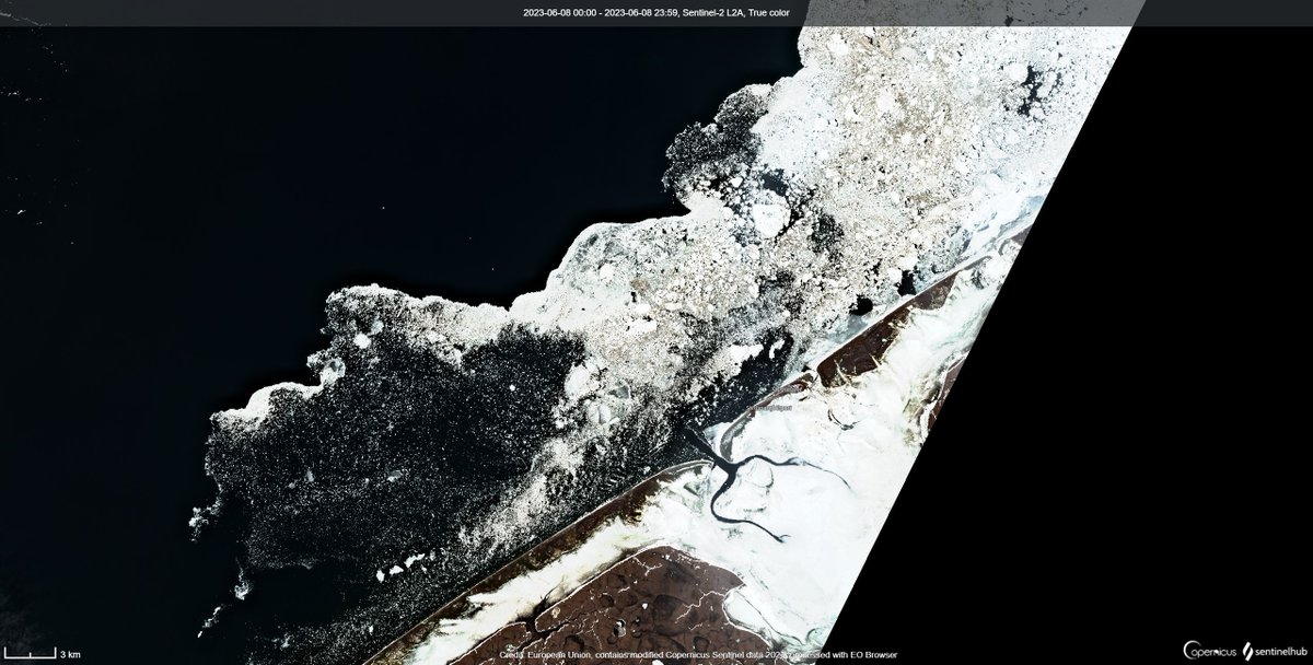
High Resolution imagery 6/8/23 of sea ice (white & tan) and near ice free (black) waters off the coast of Shishmaref . Near ice free waters 14km from the coast.
@sentinel_hub@CopernicusEU#alaskaseaice#akwx
These two synthetic aperture radar images from the Yukon Delta show how the surge of water coming down river blew out portions of the shorefast ice. Many areas that were ice 2 days ago are now open water as of yesterday @NWSFairbanks@knomradio@KYUKNews
We continue to monitor shorefast ice around the Yukon Delta. In the last week there has been increasing break-off of ice along the shorefast edge and more degradation from the shore. Offshore winds the next two days should aid in more breakup. #alaskaseaice#akwx@NWSFairbanks
Sea ice (light gray) within Norton Sound continues to melt and the remaining shorefast ice is slowly breaking off. The area of open water (black) has expanded over the past few days. For more information visit: https://t.co/4Z9JpEEhoO
@knomradio#alaskaseaice#akwx
Southerly winds have resulted in a polynya from Shishmaref to Espenberg. Expect the polynya to expand northward today. Winds expected to shift from the north tonight, so the polynya will start to fill back in as early as tomorrow (Monday). @knomradio#akwx#alaskaseaice
Time-lapse over the past 3 weeks of sea ice melting in the Kuskokwim Bay. Off the coast of Kwigillingok is close to ice free. Ice, snow, and clouds are white. Land is brown. Water is dark blue. #alaskaseaice#EOBrowser#EarthObservation#RemoteSensing
Ivu (ice shove) potential increases along the northern Norton Sound coastline Saturday afternoon through Monday as ingredients are present. Uncertainty is always large with forecasting ice shoves, but potential is there. @NWSFairbanks#akwx#alaskaseaice
Shorefast ice will be at risk of breaking off as a front brings gusty southerly winds and above freezeing temperatures to the west coast of Alaska. @NWSFairbanks#akwx#alaskaseaice
Melt season is underway as the ice edge is nearing the Kuskokwim Delta. Shorefast ice is beginning to erode from the edge. Pack ice is thinning out while open water areas grow. @NWSAnchorage@NWSFairbanks#akwx#alaskaseaice
May 2nd Satellite imagery showing sea ice, clouds, and open water. Areas of open water (yellow). Along the NW coast of Alaska, there may be an area remaining off of the fast ice (red) that is open water, but it is difficult to tell from yesterday's image #alaskaseaice@knomradio
Melt season is well underway as this high-resolution Sentinel-2 falsecolor satellite shows water on top of existing shorefast ice. These areas will grow and aid in the destabilization of shorefast ice around Norton Sound. #akwx@NWSFairbanks#alaskaseaice
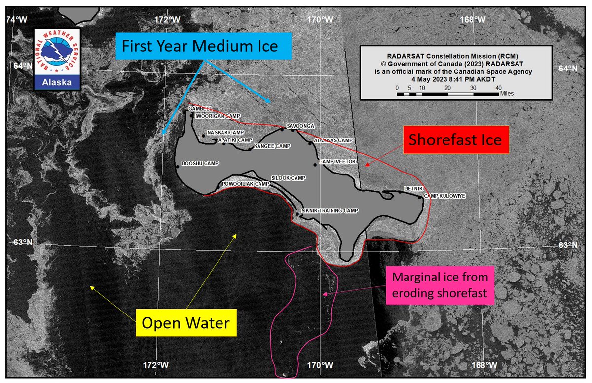
Yesterday afternoon (Saturday May 6) satellite image shows evidence of shorefast ice breaking away between Gambell and Savoonga due to southerly flow. Winds are expected to shift from the north on Monday. #akwx#alaskaseaice@knomradio
Long duration northerly winds have kept a large polynya open south of St. Lawrence Island. Southerly winds this weekend may close the polynya slightly and push compacted ice away from the shorefast ice on the north shore. #akwx@NWSFairbanks#alaskaseaice
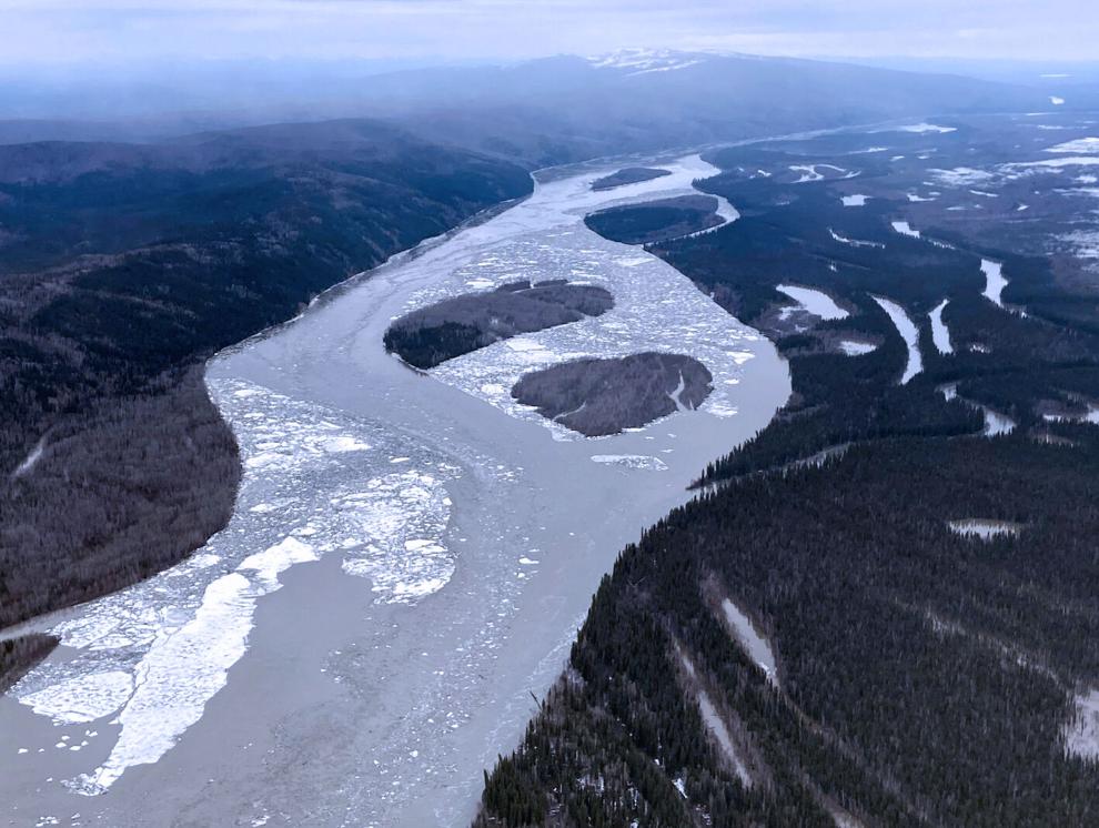
It’s break up season in Alaska, and that means flooding. But you can help predict floods and keep Alaska safe! Just pull out your camera and send pictures of river ice to @NWSAPRFC via email or use the @FreshEyesonIce photo submission! (https://t.co/jYGIPjx4xz)
#akwx#riverwatch