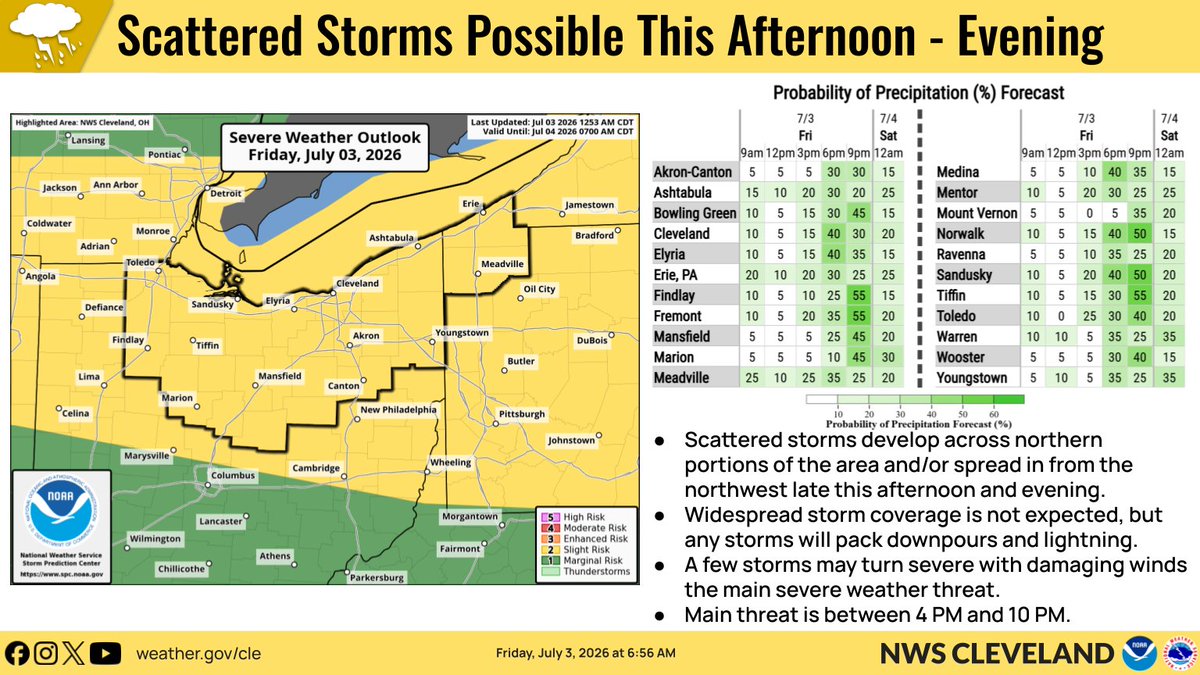
One more excessively hot day is in store today before we trend slightly cooler for Saturday. Scattered storms may develop and/or more in from the northwest late this afternoon and evening. Some storms may turn severe with potential to bring damaging winds. #OHwx#PAwx
⚠️🌡️ The Extreme Heat Warning & Heat Advisory headlines remain in effect through 8 PM Friday. ⛈️ Stay tuned to the latest forecast as we continue to monitor increasing shower and storm chances through the weekend.
July is starting off HOT! Record high temperatures were set today at Cleveland and Toledo! Make sure to find ways to stay cool during the prolonged heat this week.
⚠️🌡️ The heat headlines have been extended through 8 PM Friday as the heat wave continues across the region. ⛈️ We are also continuing to monitor the potential for showers and storms Friday through Sunday, especially in the afternoon and evening.
June 2026 temperatures averaged a little below normal and precipitation was near to below normal as well. All locations reached 90° or greater on the 30th of the month.
Our office is almost done with a webpage to look back on devasting floods 20 years ago from June & July 2006. We need your help with photos! If anyone has photos, please share them with date, location, & permission to use. Especially need pics from Norwalk, Toledo, & Ashtabula.
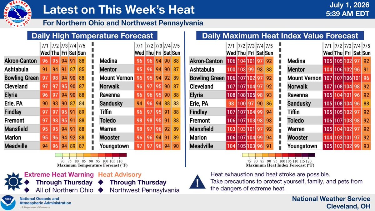
An Extreme Heat Warning for all of northern Ohio and a Heat Advisory for Northwest Pennsylvania remain in effect through Thursday. Daily maximum heat index values will range between 100 and 108°F through at least Thursday.
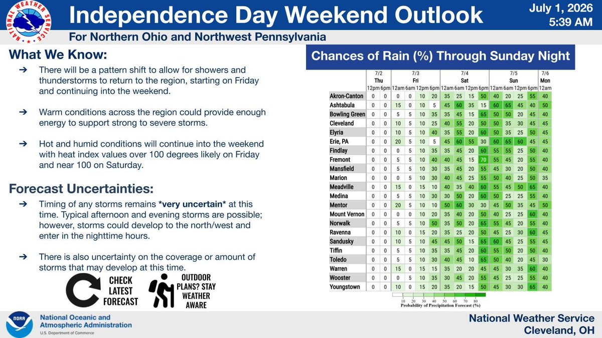
Shower and storm activity will ramp up starting on Friday and continue through the weekend. There is potential for strong to severe storms this weekend. Hot and humid conditions will continue into the Independence Day holiday weekend and extensions of heat headlines are possible.
⚠️🌡️ Extreme heat will continue across the region through at least Thursday, with maximum daily heat indices ranging between 100 to 107°F and minimum overnight temperatures in the mid to upper 70s.
⚠️🌡️ Hot and humid weather continues this week. The Extreme Heat Warning has been expanded to include all of northern Ohio through Thursday. The Heat Advisory remains for Northwest PA through Thursday. Heat Index Values of 100 to 108 are expected over the next few days.
⚠️🌡️ A prolonged period of hot and humid weather will continue through at least Thursday and potentially into the weekend. Little overnight relief is expected as lows only drop into the mid to upper 70s.
A Heat Advisory is in effect for NW OH today and most of northern Ohio for Tuesday through Thursday. Daily high temperatures in the 90s, heat index values over 100 degrees, and nighttime lows in the mid-to-upper 70s will pose a significant heat risk this week.
Heat Advisory issued for Northern Ohio starting Monday for the I-75 corridor and Tuesday elsewhere as temperatures climb well into the 90s and heat indices reach 100-105 degrees.
After some patchy morning fog, conditions will improve today and temperatures will rise into the 80s. Some spotty afternoon showers and perhaps a storm are possible in southeast portions of the forecast area.
Thanks for following along to Lightning Safety Awareness Week! Remember, you can always find lightning info, safety tips, and resources at https://t.co/fvwY4I2LiR #LightningSafety
High temperatures are forecasted to rise into the 90s, starting on Monday and lasting through the week. Don’t wait until heat arrives to begin protecting yourself. When the forecast calls for extreme heat, begin preparing NOW. Stay Weather-Ready.
Many structures provide safety during a thunderstorm, but lightning has the ability to damage them if they are struck. If a building is struck, structural fires and electrical damage can result. Here’s how you can protect your home from lightning. #LightningSafety
Some very light scattered showers will continue across portions of the area today. Temperatures will remain in the 70s. Dry weather will enter tonight into Sunday. Temperatures will return to the 80s on Sunday afternoon.