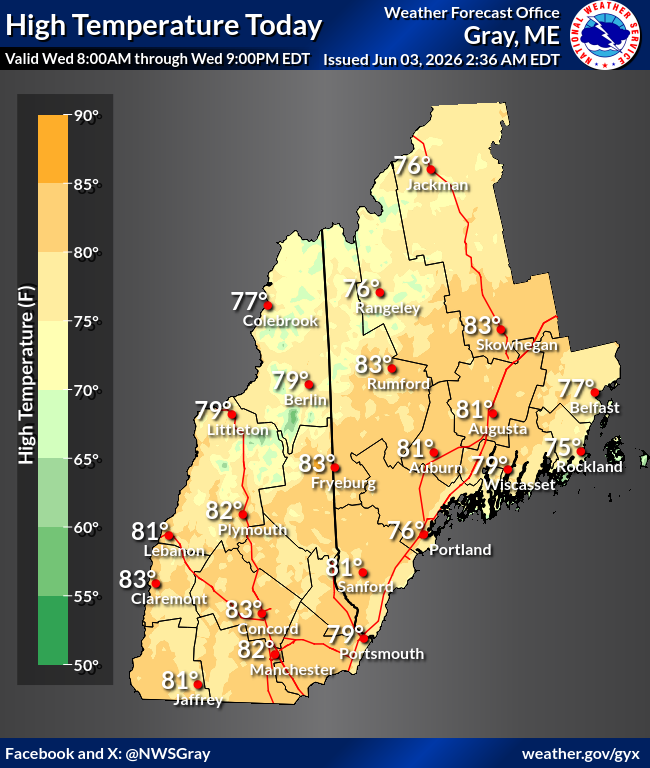
Good morning, a few days of hot temperatures are expected to end the week. Here's a look at how impactful the heat will be. High temperatures Today and Friday are expected to be in the upper 80s / lower 90s. #HeatRisk#NHwx#MEwx
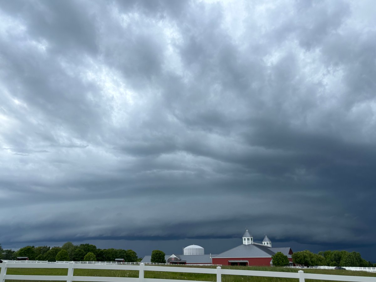
In addition to strong winds, there will be other impacts with tonight's storm system, some of which are quite rare for late May:
🌧️ A soaking rainfall with a widespread 1-3 inches
🌊 Rough surf with waves approaching 10 feet
❄️ Mountain snow
🌡️ Winter-like wind chills
#mewx#nhwx
Another hazard tonight into Sat will be strong easterly wind gusts and potential power outages. Along the coast and inland to the I-93 corridor winds may gust up to 50 mph. If you have outdoor celebrations planned this weekend, now is the time to make sure equipment is secured.
Summer isn't here just yet. A late season storm will bring cold temperatures and accumulating snow to the mountains, especially over New Hampshire, Friday into Saturday. If you plan on visiting the mountains, make sure you are prepared for winter-like conditions.
@ruggeddude95 We are still carrying notable rainfall deficits from 2025, so it will take time, but we are making steps in the right direction with a wet May occurring.
We're going into a cooler and showery pattern Thursday and through the weekend. Focusing more from late Friday into Saturday: a widespread soaking (and chilly) rain is looking likely with high elevation snow. Hikers should prepare for winter conditions above 3000 ft. #nhwx#mewx
Now that the rain has come to an end, temperatures will climb into the 60s and 70s this afternoon. Even warmer weather is ahead for Tuesday. #nhwx#meww
High rain chances continue through tonight and Memorial Day morning before conditions dry out in the afternoon. Once rain comes to an end, temperatures are expected to climb into the 60s and 70s for highs on Memorial Day. #mewx#nhwx
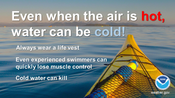
With the holiday weekend underway and air temperatures expected to be well into the 60s to near 70 degrees today, just a friendly reminder that ocean and inland water temperatures are still much colder. Take precautions when going out on the water. #nhwx#mewx
Following a dry start to the holiday weekend, precipitation will overspread the region. Here is a breakdown of the expected onset of precipitation on Sunday. #mewx#nhwx
Frost advisories and freeze warnings are in effect for tonight. Isolated spots below freezing are possible in the north, with mid 30s and frost across the foothills and lake's regions. Coastal and southern counties will be closer to 40°F. #nhwx#mewx
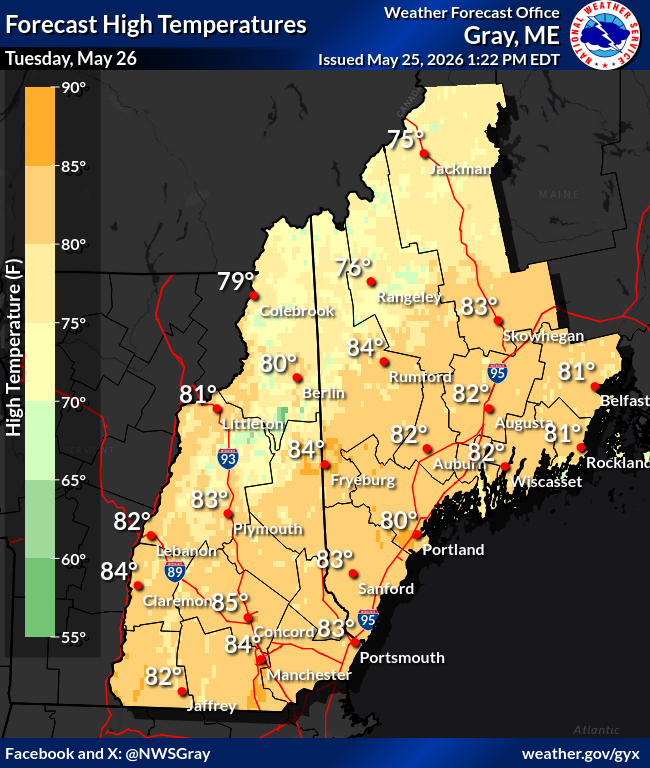
Not a fan of the heat? A return to seasonable temperatures is just around the corner! A pleasant end to the week is in store with clear skies. Unfortunately, the holiday weekend is looking unsettled, particularly on Sunday and Monday.
Special Marine Warning including the Coastal Waters from Cape Elizabeth, ME to Merrimack River, MA out 25 NM, Waters from Stonington ME to Port Clyde ME from 25 to 60 NM and Waters from Port Clyde ME to Cape Elizabeth ME from 25 to 60 NM until 6:15 PM EDT