🗺️GIS specialist at Liveby Inc. He/him. One cat, one dog, and enjoys making webmaps & UI/UX design. Journalism and education are special interests of mine too.
Although I've bailed out of the #30daymapchallenge, I've gotta say that it's definitely been inspiring to see all of these skilled mapmakers around the globe.
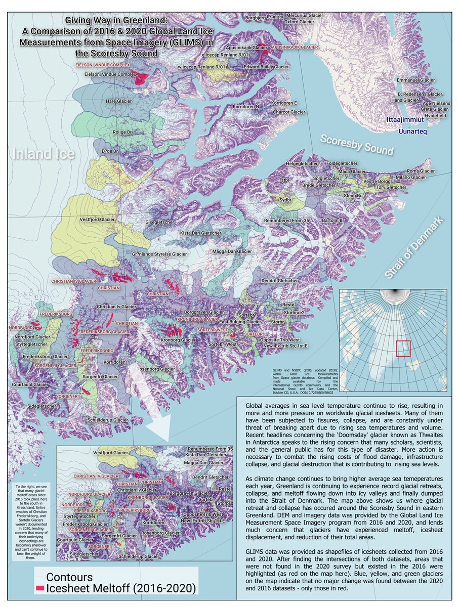
Taking a break from being told what to do on the #30DayMapChallenge. Decided to look at the Glacial Land Ice Measurements from Space icesheet shapefiles from 2016-2020 in the Scoresby Sound of eastern Greenland.
Icesheet displacement and meltoff is up.
#gis#noaa#nasa
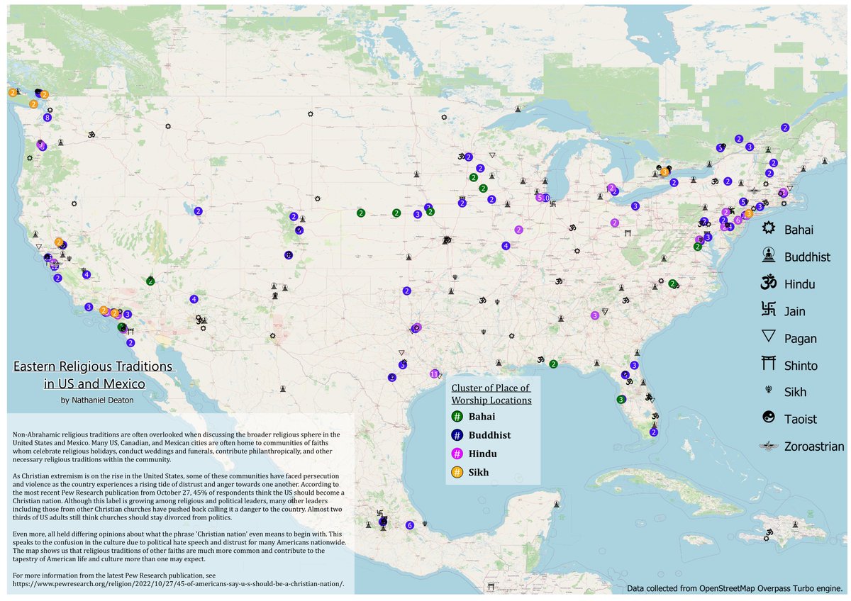
Day 8: Open street map data!
Nothing better than crowdsourced data. Made a search for places of worship excluding Abrahamic traditions. This map showcases eastern religious traditions and their places of worship in North America.
#30daymapchallenge#gis#gismapping
Day 7 is raster day.
Created a 1/3 arc-second DEM / hillshade in Perry County in eastern Kentucky; looking at the areas of low and high slope / active mining sites.
No surprise that areas of high mining activity are also leveled and slope-less on the map.
#30DayMapChallenge
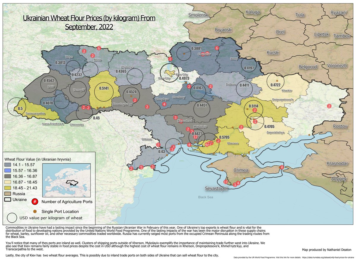
Today for the #30DayMapChallenge, I decided to take a look at Ukrainian wheat flour commodities. In general, food prices and exports have been considerably disrupted by the war - wheat flour is no exception. #StandWithUkraine️#WFP
I'm enjoying the concept of the #30DayMapChallenge, but working two jobs really kills the motivation. And I refuse to except the notion that this is anything to be stressed about. Have fun with it, people.
Very much agree with your analysis, @mapbosse.
Playing catch-up with the #30DayMapChallenge. Because we're on polygons today, I've created a chloropleth of rare earth mineral densities worldwide according to the #USGS.
Fun facts: Canada has the highest reserves of REE worldwide while China produces 60% of worldwide supply.
Already a day late into the #30DayMapChallenge. Proves the bar should remain low and not become stress-inducing. Hopefully it's a fun experience and gives us the chance to enjoy our craft. Below, a map of e-scooter injuries vs. bicycles in @LexingtonKyGov. https://t.co/WqoPp2ijRm
@caseymmiller lots of great potential uses for your image --> layers tool. School attendance boundaries are usually published by school districts as pdfs and rarely ever georeferenced. Definitely looking forward to using your tool for this type of problem!
Did you know Freddie Mercury was born in Zanzibar and Barack Obama in Honolulu? Who is the most famous person from your home town?
I made a map of the most notable people around the world. Built with @Mapbox.
Check it out here: https://t.co/NR0J7nqTn1
🧵
Useful @guardian map showing how much of the territory Putin is “annexing” isn’t even under Russian control. The total territory is about 15% of Ukraine and includes major cities. Under Russia’s amended constitution, no Kremlin leader can cede territories once they are annexed.
Currently looking for help in the field of crisis mapping. I'm hoping to utilize front-end design tools and frameworks for desktop and mobile-facing data web maps and visualizations within this field. Any assistance would be duly appreciated.
#mapping#QGIS
Superb news that the James Webb Telescope is now fully deployed. The fun continues with instrumental calibrations for the next 6 months, and hopefully imagery within that timeframe.
https://t.co/t3I9eagxjU
The CKWR in Boyle County offers an excellent venue for visitors to hike, learn, and experience the biodiversity of various native plants and wildlife. Check out the park's new map as well as more information about how you can help today. https://t.co/BtGZ80GQEB