Meet Plucky, NavLive's four-legged surveyor and the newest (and most energetic) member of our team!
We've mounted our LiDAR payload onto an autonomous quadruped, with the ability to rove, scan, and SLAM its way through a building so you don't have to.
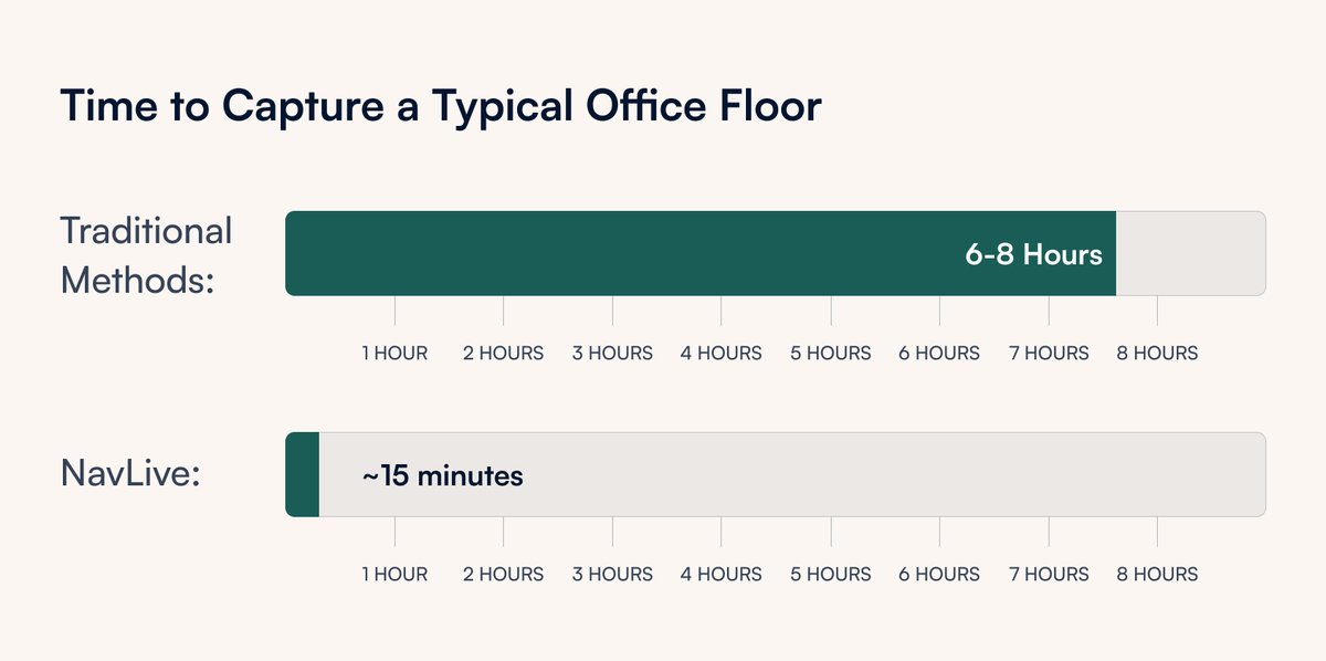
Visit our booth for hands-on time with the NavLive handheld scanner, designed specifically for construction, and experience first-hand how NavLive generates RICS-grade measurements for any space in minutes, simply by walking around the site.
Noisy point clouds slow down drawing workflows. Stray points, fuzzy surface planes, scanner artefacts, they all add up.
We've been working on an automatic denoising step inside the NavLive Portal that cleans this up in one click
Point Cloud Denoising in NavLive works on all your scans, including legacy ones already in your account.
Full writeup on our blog 👇
https://t.co/JW5ZlKdthI
We've just added Point Cloud Denoising to the NavLive Portal. One click of the Magic Wand button automatically cleans and sharpens your point cloud, giving you tighter surface planes, less noise, and a point cloud that's easier to draw from.
We just launched Scan2Plan, a new NavLive service that turns your NavLive scan data into professional architectural drawings, without you touching a single piece of CAD software.
Select a scan in your Portal, and we handle the rest. Finished floor plans delivered in days.
We spent the morning at the London PropTech Show (@ProptechShow) today, showcasing NavLive's next-generation handheld 3D building scanner.
Whilst there, of course, we scanned the exhibition floor. It took us just 10 minutes to capture the full 1,948m² floorplan...
And of course, a special thanks to our amazing team in London, Oxford, and beyond.
Everyone is working tirelessly to deliver the best handheld 3D building scanner on the market, and we are so grateful for this amazing recognition! 🚀
A big thank you to the people who’ve helped make this happen: Our customers, who are out there using NavLive on real projects every day, our partners, who’ve worked closely with us to open up new opportunities across the industry, and the wider construction and AEC community.
We've put together a full walkthrough of the workflow on the NavLive blog if you want to see exactly how each step works:
https://t.co/4piWhubkYl
#Architecture#Surveying#FloorPlans#BIM#NavLive
Same result. Fraction of the time.
The thing that surprises people most isn't the scanning speed, it's that the data is ready before you've left the building. No processing delays, no back-and-forth. Your team can start work the same morning.