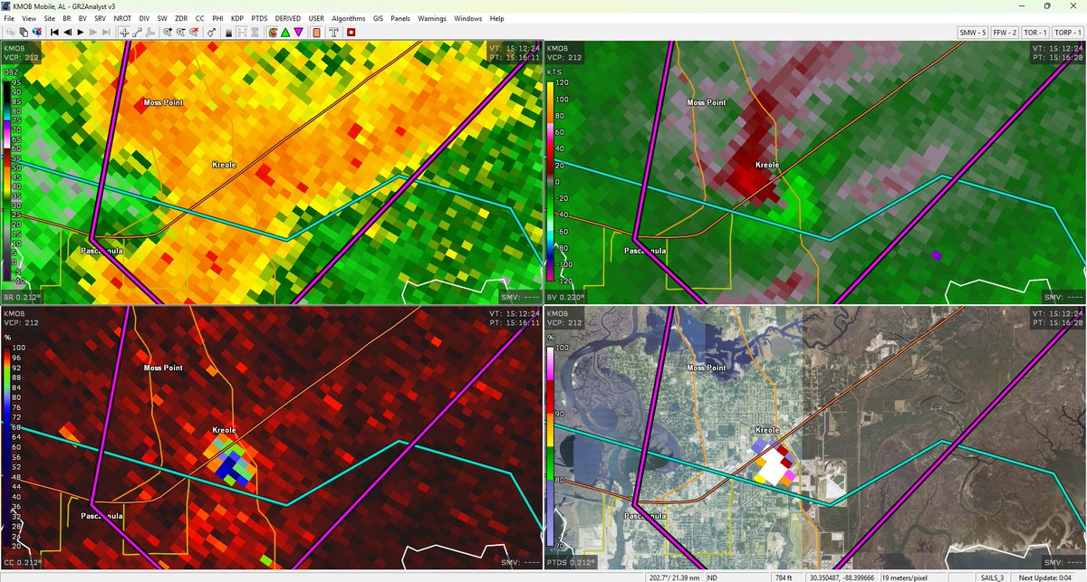
Strong tornado ongoing in the Kreole/Moss Point, MS area. THIS IS A PARTICULARLY DANGEROUS SITUATION, SEEK SHELTER NOW IN SOUTHEASTERN JACKSON COUNTY MS!
LAKE CHARLES, LOUISIANA:
A tornado is likely still on the ground, and will enter downtown in the next minute or so. This tornado has produced damage in the Sulphur, LA area. TAKE SHELTER NOW!
With us entering the fall/winter storm season, we are starting to pay attention to the synoptically evident severe events. It appears like the first event of the season will occur this Saturday, Oct 18.
⤵️
While it is not the most incredible or intense severe event we've seen this year, it is definitely something to pay attention to! Please monitor the Storm Prediction Center and your local NWS office, and this account for further updates in the coming days!
⤵️
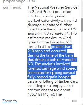
in addition to the ef5 DI's, a previously ef-3 DI has been upgraded to EF4 180mph, both FR12 DI's, and another was upgraded to EF4 170, along with new Low End (LE) EF4 tree damage (hardwood)
(post was made by @SuperCellzWX )
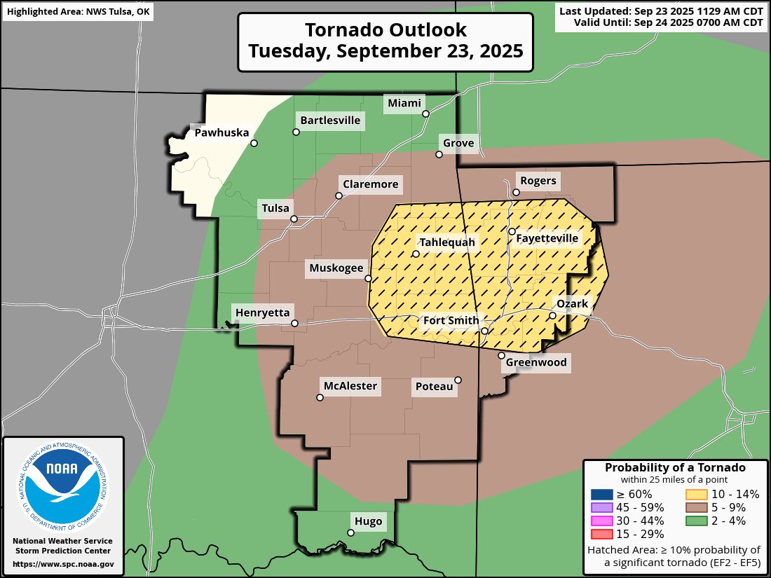
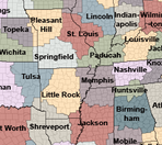
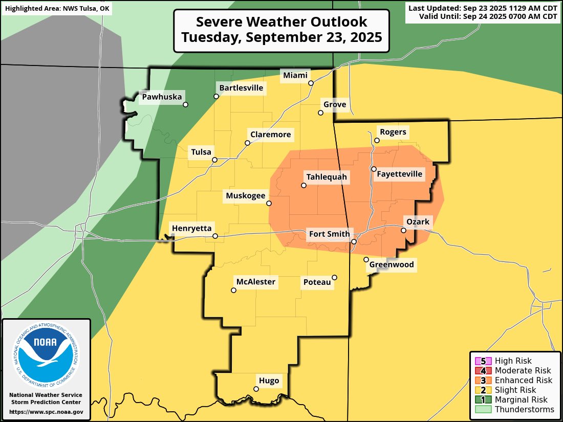
Overall, a significant day is ahead for NE Oklahoma, NW Arkansas, and SW Missouri. Be sure to follow your local NWS Office on social media for updates, and take all warnings seriously. 🧵(3/3)
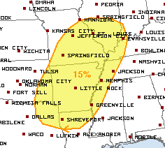
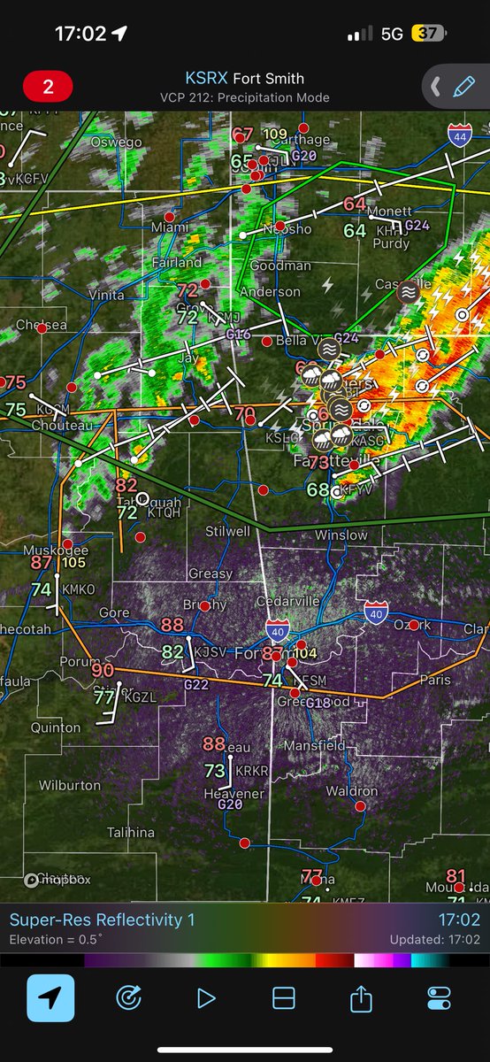
12 PM CDT Update: Today is starting to look more and more volitile as time goes on. The SPC has upgraded today's risk to Enhanced, with 10%# area for strong tornadoes, stretching west to east from Muskogee, OK, to Clarksville, AR, and Fort Smith, AR, to Bentonville, AR. 🧵(1/3)
Both temps and dews are running ~5°F above what was modeled, with Stigler, OK reporting an astonishing 90/77. Clearing has already begun, and a boundary has established across the target area. Backing flow is also present across the area, with winds out of the SSE. 🧵(2/3)
In regards to this, a more major threat *is* expected today, with damaging winds up to 100mph possible per latest SPC update over parts of ND and SD, as well as hail up to 3.5 inches!
A few lower-end severe events are possible across the upper Midwest through this weekend! No day shows any major potential currently, but damaging winds, large hail, and a tornado or two could be possible every day.
A few lower-end severe events are possible across the upper Midwest through this weekend! No day shows any major potential currently, but damaging winds, large hail, and a tornado or two could be possible every day.
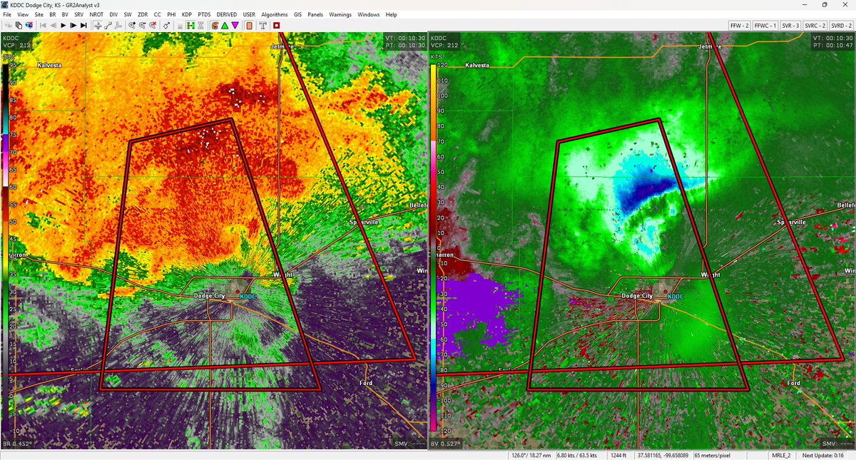
Dodge City, Kansas:
A destructive thunderstorm with winds gusting to 90+ mph is entering Dodge City from the north. Treat this like a Tornado Warning. THIS IS AN EXTREMELY DANGEROUS SITUATION, SEEK SHELTER NOW!
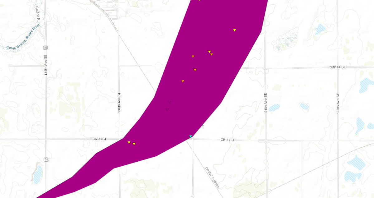
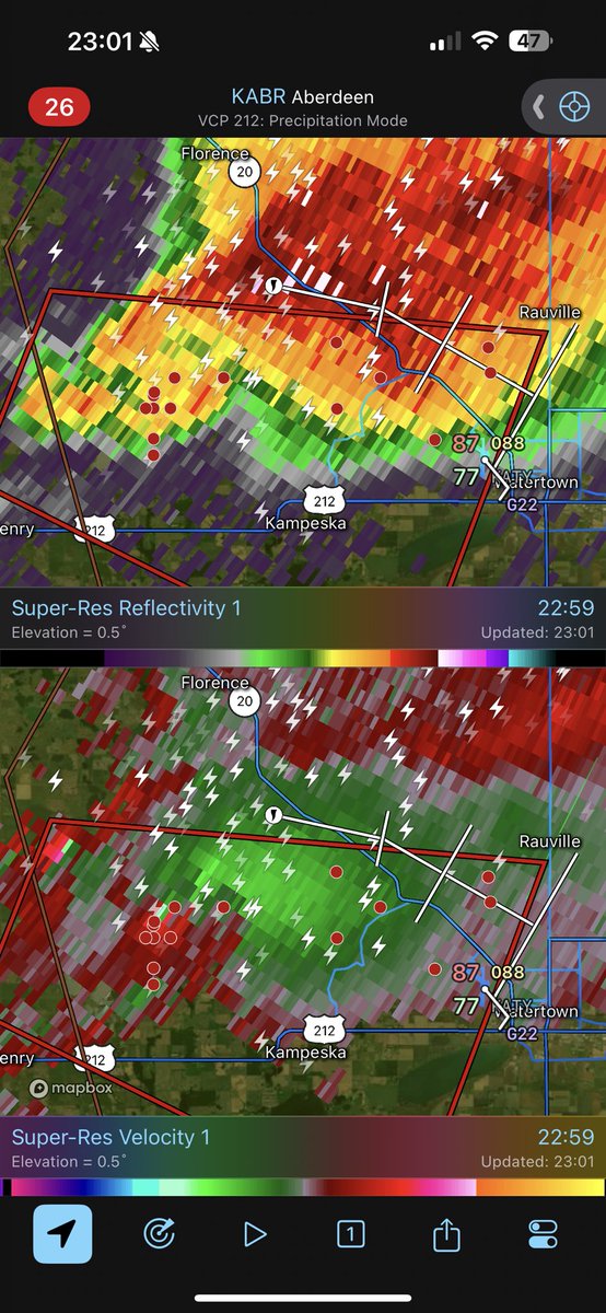
INTENSE TORNADO ON THE GROUND NEAR WATERTOWN SD, Via @BrandonCopicWx , THIS IS A PARTICULARLY DANGEROUS SITUATION TAKE SHELTER NOW in Kampeska and Watertown SD!!