An ACTIVE weather pattern kicks into gear tomorrow & will take us thru at least the middle of June. This will provide several opportunities for T'Storm activity. Meanwhile, some serious HEAT & Humidity will creep into the picture later next week. Here is your extended outlook.
Check out some of these estimated rainfall totals over the Dakotas. Widespread 2.00"+ with some localized totals over 5.00"+! Eventually, this moisture will spread into MN over the next 48 hours. Our soils needs a drink, but hopefully it is not too much.
Did you know that Novak Weather produces private forecasts/consulting for large multi-million dollar organizations? This latest 30 day precipitation outlook for June was sent to a client yesterday. Check it out!
The atmospheric dynamics will be perfect for several heavy RAIN events over the next couple of weeks as a strong jet stream & streak races overhead. In turn, Gulf moisture will be allowed to surge north into MN/WI. Here is the set-up.
Get ready to sweat. WARM & HUMID conditions will promote an ACTIVE atmosphere later this week. This is good news since many of us could use the moisture. Meanwhile, this weekend looks pretty nice. Here is your extended outlook.
A much more ACTIVE & humid weather pattern kicks into high gear later this week & will extend into next week with the potential for some severe weather. Meanwhile, temperatures will continue to run near or above normal. Yep, summer has arrived. Here is your extended outlook.
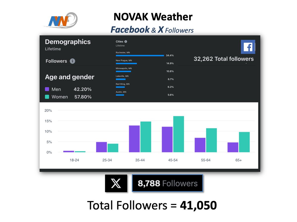
Over 40,000+ loyal people follow Novak Weather with most of them residing in southern MN including the Twin Cities & Rochester. Imagine reaching all of these awesome followers. Become a SPONSOR. I would love to have you on board. Message me for more info.
My unique weather platforms continue to flourish. We now have well over 40,000+ loyal followers. Meanwhile, I still have room for more dedicated SPONSORS who believe & trust this platform. It is an awesome way to promote your product. Message me for more info.
The WARMTH will stick with us for at least the next 10 days. Meanwhile, clouds will be on the increase this weekend & we actually have an opportunity for some showers/T'Storms. This is good news. Here is your extended outlook.
The latest 12z HRRR & other short term guidances continue to paint scattered significant RAINS across a good chunk of southern MN & northern IA over the next 24 hours. Some of us will likely get lucky today.
It is not alarming yet, but DROUGHT conditions are starting to deepen over much of the Upper Midwest. The greatest concern is in MN Cabin Country. Good news is that moisture is on the way, especially next week. Here is your latest Drought Index map.
Finally, our prospects for much needed moisture looks promising, especially as we head through next week. Meanwhile, the WARMTH will continue with near or above normal temps expected thru the period. Here is your extended outlook.
We are well on our way to a beautiful weekend in northwest WISCO as warm, sunny & dry conditions dominate. This should be the case thru tomorrow. Eventually, a few clouds & an isolated shower may creep in for Sunday. Here is your 'NORTHWOODS' outlook.
@RaminRnp So, you think that Delta, United, etc. would rather produce chemtrails in specific locations then try to be efficient with their routes in an effort to make a profit? Perhaps you think the Government is flying jets up there just to produce chemtrails? Crazy.
Except for a few widely scattred showers/T'storms, it will be mostly DRY up in MN Cabin Country this weekend. However, as clouds steadily increase, temps will cool a bit by Sunday. All in all, another nice relaxing weekend. Here is your 'UP NORTH' outlook.
MN Cabin Country will start off warm this weekend but gradually cool some as clouds & a few showers creep into the picture. All in all, a pretty nice weekend for late May. Here is your 'UP NORTH' outlook.