પાણી:-
વરસાદ ઓછો થવાના કારણે ભૂગર્ભ જળ ઉંડા જશે. ગુજરાતમાં 10 વર્ષમાં 4 મીટર વધારે ઉંડા ઉતરી ગયા હો એવા વિસ્તાર વધી ગયા છે. જળસંકટને દૂર કરવા વિજય ર��પાણી અને ભૂપેન્દ્ર પટેલની સુજલામ સુફલામ પાણી સંગ્રહ કરવાની યોજનામાં 10 વર્ષમાં 8 હજાર કરોડનો ખર્ચ બહું સફળ થયા હોય એવું લાગતુ નથી.
The #monsoon onset is expected to be quite weak.
From mid-June onwards, #rainfall is likely to decrease #significantly across most parts of India, with below normal rainfall expected in many areas.
Past CPCs followed a clear pattern—DA merger and Interim Relief during delays.
👉 If the 8th CPC recommendations are delayed, the govt should follow the 5th & 6th CPC approach and grant Interim Relief or DA merger to protect employees from inflation.
#8thpaycommission#8thcpc
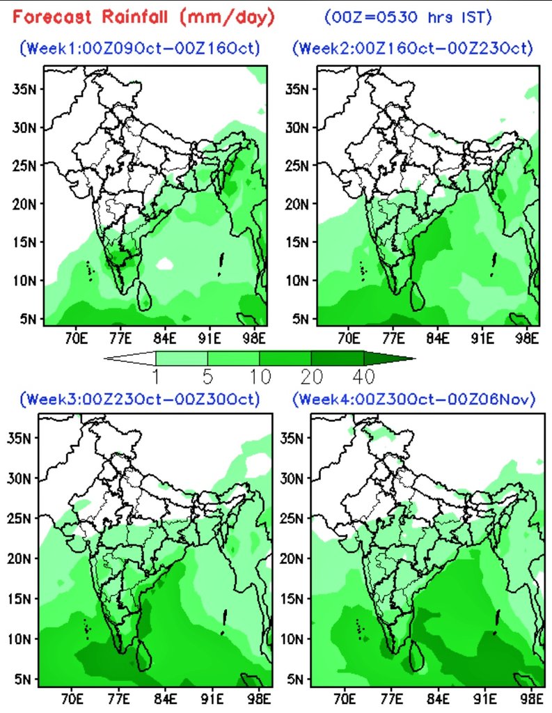
9/10,Extended Range RF forecast:
Wk 1:Above normal AN likly S-Ka, AP, TN & NMMT
Wk 2:AN likly; M_Mah,Konkan- Goa, N-Ka,Telangana, AP
Wk 3:AN likly; S India,W India, Central India,Odisha,Jharkhand & GWB
Wk 4:AN likly;Kerala,TN,S Ka, Konkan-Goa,M Mah,Guj,West MP, Ch'garh,Odisha
IMD
A monsoon depression or Intense LPS likely to affect central India during 25-30 September. This will bring heavy showers over Madhya Pradesh, Telangana, Gujarat, Odisha and parts of northeast India during last week of September.
Video Courtesy weathernerds.
i’ve made a few hundred shorts
and now i never get less than 100% retention
mostly cuz of how i write my scripts
here’s exactly how i do it + examples from my first channel 🧵
Watch out #Telangana#MadhyaPradesh#Chhattishargh#Mumbai#Maharashtra
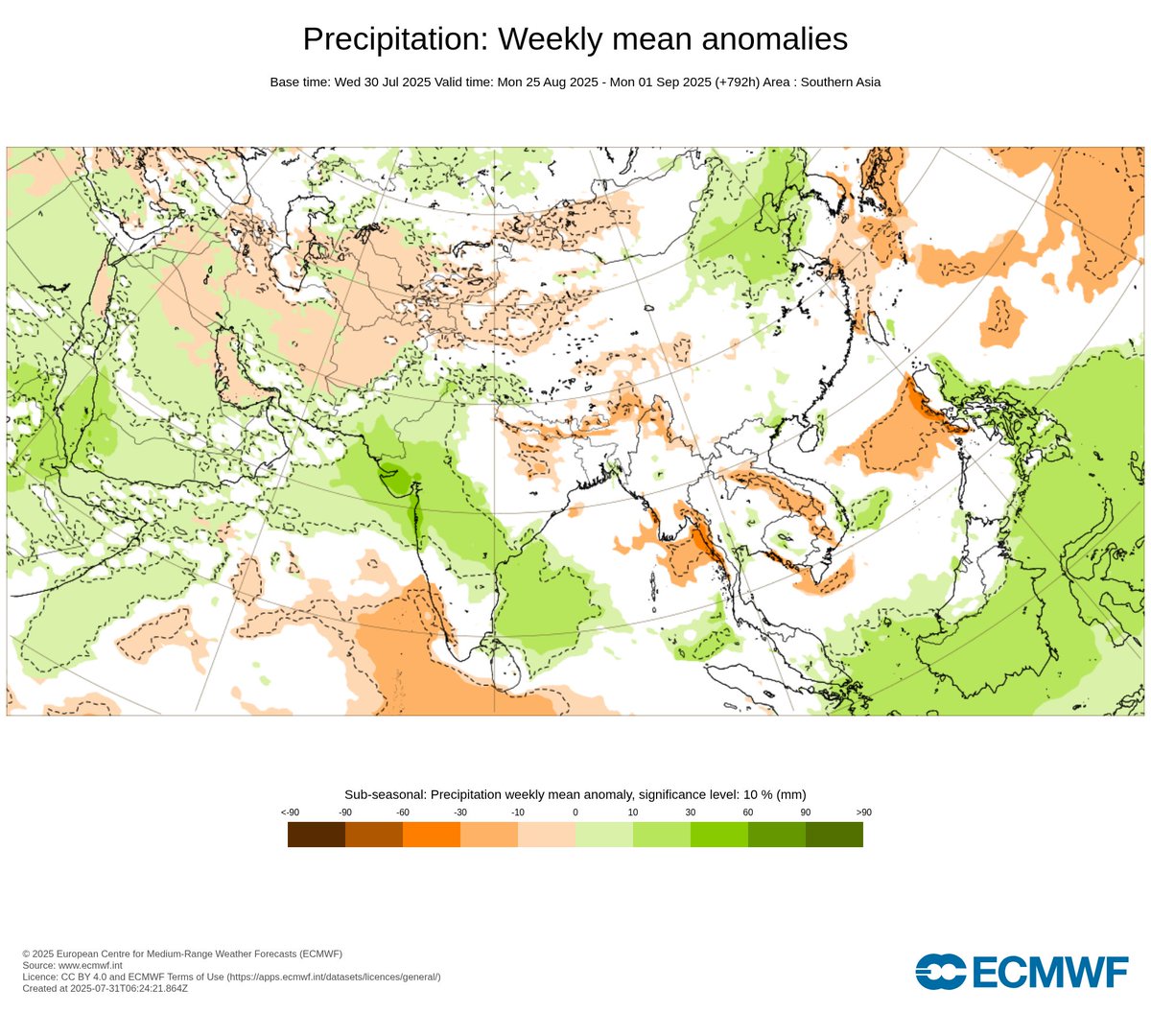
Recent MME consistent with big rain spell for parts of #Telangana#Maharashtra#AndhraPradesh#Karnataka#Goa#Konkan#MadhyaPradesh associated with low pressure movement along central parts of the country in response to monsoon transition to active phase .. Northward moving MISO is the major dominant mode that cause significant intra-seasonal rainfall variability through active & break phases
Now active convective phase likely to affect through elongated cloud bands/low pressure area & it may shift northward gradually by 2nd half ..
West-NW India adj #Pakistan also likely to be wet
during the Mid Aug.
North TN-SAP also likely to see increased thunderstorm activities in the coming days a;ong with interiors of TN-S Int kar...
Usually in aug interior storms take a long journey to reach coastal areas casing late night rains..lets see how that pattern behaves in this season for #Chennai adj districts..
dc @ECMWF@NWSCPC@NOAA
#Monsoon #Monsoon2025 #SWM2025 #Rainupdate #Heavyrains #Monsoonupdate #HyderabadRains #telanganarains #ChennaiRains #Gujarat #MadhyaPradesh #Odisha
Visceral fat is the most dangerous fat in your body.
It wraps around your organs, slows your metabolism, and silently fuels disease.
Here are 9 science-backed habits to shrink it naturally: 🧵
1. Stop eating late
ELEVENLABS WHO?
This voice AI is open-source, ultra-expressive, and actually beats ElevenLabs in quality.
No paywalls. No weird licensing.
Just pure, controllable speech synthesis — built for creators and devs.
Here’s the model everyone’s switching to: 👇
#Monsoon2025 has further advanced today, touching #Minicoy in #Lakshadweep, covering half of Sri Lanka, more parts of SW and central #BayofBengal.
NLM now passes through south #ArabianSea, Minicoy, Comorin, Chilaw, Vakarai, central Bay and Sittwe.
Over next 2-3 days, monsoon is likely to take a big leap to cover entire south Arabian Sea, Lakshadweep, parts of #Kerala, entire Sri Lanka, more parts of central Bay and enter NE #Bharat.
Monsoon will reach the mainland and make onset over Kerala by 23/24th May!
About Advance of Southwest 2025 on 13th May 2025:
1) Widespread moderate rainfall with heavy rainfall at a few places occurred over the Nicobar Islands during past 24 hours. Thus, the widespread rainfall with isolated/scattered heavy rainfall continued over the Nicobar Islands during past 2 days.
2) The strength and depth of westerly wind increased continuously during past 2 days over parts of south Bay of Bengal, Nicobar Islands and Andaman Sea. The westerly wind speed at 1.5 km above mean sea level is above 20 knots and the depth of westerly wind over some parts of south Bay, Nicobar Islands and some parts of Andaman Sea is up to 4.5 km above mean sea level.
3) The Outgoing Longwave Radiation over the area continued to decrease becoming less than 200 W/m2 during past 2 days (190 &170 W/m2 on 12th & 13th May, 2025).
Considering all the above satisfied criteria, southwest Monsoon has advanced into some parts of south Bay of Bengal, south Andaman Sea, Nicobar Islands and some parts of north Andaman Sea today, the 13th May, 2025. The Northern Limit of Monsoon passes through 5°N/75°E, 5°N/80°E, 6°N/86°E, 8.5°N/90°E, Hut Bay, 13°N/95°E. and 16°N/98°E.
Conditions are favorable for further advance of southwest Monsoon over some parts of south Arabian Sea, Maldives & Comorin area; some more parts of South Bay of Bengal, entire Andaman & Nicobar Islands, remaining parts of Andaman Sea; and some parts of central Bay of Bengal during next 3-4 days.
#IMD #Weatherupdate #mausam #monsoon #southwestmonsoon #rainfall
@moesgoi@ndmaindia@DDNational@airnewsalerts