Rain and thunderstorms Wed afternoon-evening. Some damaging winds or large hail possible. A tornado can't be ruled out in southern Michigan, but the greater threat is in Illinois and Indiana. Flooding is possible in southern Michigan as a few inches of rain may fall quickly.
🌩️ Ottawa County has seen its share of severe weather lately, and there is no better time than now to make sure you and your family are prepared.
Take a few minutes today to review your severe weather plan:
✅ Know where you'll go if a tornado warning is issued.
✅ Enable emergency alerts on your phone.
✅ Build or refresh your emergency kit with water, food, medications, flashlights, and batteries.
✅ Identify multiple ways to receive weather warnings, especially overnight.
✅ Discuss your plan with family members so everyone knows what to do.
🚨 Remember: Outdoor warning sirens are designed to alert people who are outdoors. They are not intended to warn people inside homes, businesses, or other buildings. Make sure you have multiple reliable ways to receive weather warnings, including overnight when you may be asleep.
Severe weather can develop quickly, but a little preparation today can make a big difference when every second counts.
Learn more about emergency preparedness at https://t.co/86pQsH3ef5 or call Ottawa County Emergency Management at 616-738-4052.
#OttawaCountyEmergencyManagement #SevereWeatherPreparedness #BePrepared
⚠️ Traffic Alert ⚠️
Blendon Township firefighters are currently on scene of a hazardous materials incident.
Tyler Street is closed between 64th Avenue and 72nd Avenue and is expected to remain closed for an extended period. Please avoid the area and seek an alternate route while emergency crews work to safely manage the situation.
At this time, there is no danger to the public, and we do not anticipate any impact beyond the immediate incident area.
We appreciate your patience and cooperation.
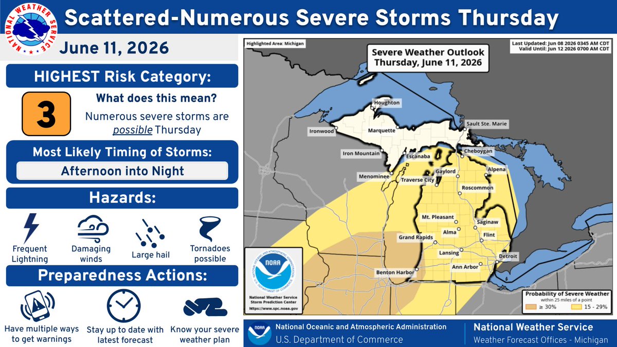
⚠️ Severe Weather Expected Across Ottawa County Today and Thursday ⚠️
Ottawa County residents should prepare for two rounds of potentially severe thunderstorms over the next 48 hours.
🌫️ This Morning
Areas of dense fog may reduce visibility, especially near Lake Michigan. Conditions should improve by late morning.
🌡️ This Afternoon
Hot and humid conditions will develop with temperatures near 90 degrees.
⛈️ Round 1: Wednesday Evening (Approximately 5 PM to 9 PM)
Strong to severe thunderstorms are expected to move across Ottawa County from west to east.
Potential hazards include:
• Damaging winds over 60 mph
• Large hail
• Frequent lightning
• Heavy rainfall
⛈️ Round 2: Thursday Evening and Overnight
A second round of storms is expected Thursday evening and may be stronger than today's storms.
Potential hazards include:
• Damaging winds
• Large hail
• Isolated tornadoes
• Torrential rainfall
• Localized flooding
🌧️ Flooding Concerns
Repeated rounds of thunderstorms may bring 1 to 4 inches of rain through Thursday night. Localized flooding of roads, low lying areas, and small streams is possible.
✅ Take Action Now
• Secure outdoor furniture and loose items.
• Charge electronic devices.
• Have multiple ways to receive weather warnings, especially overnight.
• Never drive through flooded roadways.
Stay weather aware and monitor trusted sources for updates, watches, and warnings.
For preparedness information, visit https://t.co/86pQsH3ef5 or call Ottawa County Emergency Management at 616-738-4052.
#OttawaCountyEmergencyManagement
Thunderstorms Next Several Days
Monday evening through Tuesday evening: Scattered thunderstorms, severe wind or hail not expected, localized 1 to 3 inch rain totals with temporary minor flooding of low or poor-drainage spots.
Wednesday afternoon-night and Thursday afternoon-night: Severe thunderstorms possible in portions of Michigan.
Heat and Humidity Midweek
Wednesday-Thursday: High temperatures mid 80s to lower 90s favored, uncomfortably high humidity, with a Heat Index (feels like in the shade) in the 90s to near 100.
Heat illness a concern for some individuals.
When severe weather or disasters strike, your devices can be some of your most important tools, but only if they are charged, protected, and ready to use. Taking a few simple steps now can help you stay informed, connected, and prepared.
✅ Download the FEMA app for weather alerts and emergency information:
https://t.co/5otQPIYd9F
✅ Sign up for FEMA text updates:
Text PREPARE to 43362 for preparedness tips
Text SHELTER and your ZIP code to 43362 to find open shelters
✅ Follow trusted local and government agencies on social media for official updates before, during, and after emergencies.
✅ Keep phones, tablets, and backup battery packs fully charged before severe weather arrives.
✅ Save important documents securely in the cloud or on a password protected flash drive.
✅ Back up photos, medical records, insurance information, and pet records to protect them from loss.
✅ Use text messages or group chats to communicate during emergencies. Texting often works better than phone calls when networks are busy.
Preparedness starts before the emergency happens. Take time today to make sure your technology is ready when you need it most.
More preparedness information:
🌐 https://t.co/3fYdXnxNz8
🌐 https://t.co/HNG5Oe73aF
#OttawaCountyEmergencyManagement
The Michigan State Police Emergency Management and Homeland Security Division (MSP/EMHSD) is now accepting applications for the Michigan Safe Room Rebate Program designed to help eligible homeowners offset the cost of installing a Federal Emergency Management Agency (FEMA) compliant tornado safe room on their property.
“We’ve already faced the threat and destruction of tornadoes multiple times this year. In a single night, nine tornadoes touched down across Michigan, just weeks after three others tore through southwest Michigan, causing widespread damage and claiming four lives,” said Capt. Kevin Sweeney, deputy state director of Emergency Management and commander of the MSP/EMHSD. “A properly constructed tornado safe room can provide critical life-saving protection during severe weather events.”
Selected applicants who meet requirements may receive a rebate covering up to 75% of eligible costs associated with the installation and construction of a tornado safe room, with a maximum reimbursement of $7,131.75.
The proposed rebate program would be funded through the FEMA Building Resilient Infrastructure and Communities (BRIC) Grant Program. At this time, no funding has been awarded. The application process is being used to support Michigan’s application for the program.
Interested homeowners should complete an online application. Fifty applicants will be chosen through a random selection process, with an additional 100 applicants identified as alternates pending available funding.
Applicants must be residents of Michigan and own a permanent residence located in Michigan and will be grouped by FEMA risk categories to ensure geographic distribution across the state.
The rebate program is reimbursement-based, meaning homeowners must complete the installation and submit required documentation before receiving payment. Safe rooms installed prior to approval are not eligible for reimbursement.
Visit the Michigan Safe Room Rebate Program resource website to apply or learn more about program eligibility, requirements and rules.
https://t.co/9ktRWMCexA
Application here.
https://t.co/vO5duS8ZPI
Joint EGLE-USGS airborne electromagnetic survey collecting data on region's geologic makeup, creating more accurate models of groundwater systems
It’s a bird - it’s a plane - no it's … airborne electromagnetic surveying! Over the next few weeks, if you see a helicopter flying relatively low with a large, hexagonal-shaped hoop hanging below it, don’t be alarmed. It is all part of a special survey being conducted by the U.S. Geological Survey (USGS) with support from the Michigan Department of Environment, Great Lakes, and Energy (EGLE). This effort is collecting geophysical measurements to create high-resolution, three-dimensional models of the region's aquifers and geology. The data will improve USGS bedrock maps and inform groundwater management efforts.
Although the joint EGLE-USGS effort is scanning portions of 15 counties across the southwest portion of the state, USGS will be paying special attention to Ottawa County. The County’s Department of Strategic Impact requested USGS conduct denser and more detailed scans of the central portion of the County - areas where residents and businesses are facing major groundwater quality and quantity issues.
"These denser passes by the USGS helicopter will provide us with higher resolution scans of the Marshall aquifer. With better data, we better understand the situation underground, supplementing our groundwater monitoring and management efforts," said Land Use Coordinator Matt Chappuies.
How it Works
This scanning system will catch people's attention - a helicopter flies approximately 200 feet overhead with a 60-foot-wide Airborne Electromagnetic (AEM) transmitter hoop suspended by cables horizontally about 100 feet below the aircraft. As the chopper passes over an area, a weak magnetic field penetrates the ground, measuring how well the ground conducts electricity. The resulting scans provides high-resolution data used to create three-dimensional models of the earth's subsurface to a depth of more than 1,000 feet.
Is it Safe?
The USGS says the AEM hoop does not pose health or safety risks. The low level of magnetic field exposure given off by the transmitter is less than one-one hundredth (1/100th) of the accepted general exposure level, or about the same as standing a foot from a toaster in operation.
During data collection, the helicopter pilot will not fly within 500 feet of buildings, and will make every effort to avoid people, livestock, or large equipment. It’s important to note the helicopter is flying a pre-determined grid based on study locations, so it will pass through the same area several times.
Track the Flights
The public can track the path of the USGS helicopter by visiting the Flight Tracker map. For more details on the project, visit USGS-EGLE AEM Surveys for Southwest Michigan website. See the scanning system in action by watching this video.
Have Questions?
For general project questions, please contact either:
• EGLE’s Sydney Ruhala at [email protected] or 517-648-7791
• USGS Research Geophysicist and AEM Lead Burke Minsley at [email protected] 303-236-5718
• For more information on Ottawa County groundwater issues, visit https://t.co/5S7anvDVmp.
All warnings for Ottawa County have expired, and the Thunderstorm Watch for Ottawa County has been cancelled.
Please continue to be aware of your surroundings as crews assess conditions across the area. There may still be hazards present, including downed power lines and debris.
Never approach or drive over downed wires. Report hazards to local authorities or your utility provider.
Thank you for staying weather aware and safe this evening.
#OttawaCountyEmergencyManagement
Ottawa County Emergency Management will conduct a routine test of the Outdoor Warning Siren system at 12:00 PM (noon) on Friday.
This is only a test. During the test, sirens will sound briefly across the county as part of regular maintenance to ensure the system is working properly.
If you hear the sirens at noon on Friday, there is no emergency and no action is needed.
Remember, outdoor warning sirens are designed to alert people who are outside to seek additional information during an emergency.
Rain/River Flooding Update
The Lower Muskegon River basin, and isolated pockets of the Grand River basin received another 1-3" of rain over the last 24 hours
Major Flooding is occurring/forecast for the Muskegon River at Evart, Newaygo, Bridgeton, and near Croton Dam
Minor to Moderate Flooding is now forecast for almost all locations on the Grand River from Lansing westward
This Grand River crest is expected to reach or exceed levels set earlier this month
Check https://t.co/qXjo6yQT2K for additional river forecasts in your area
Additional rainfall up to 0.25" expected through this evening, totals this weekend will range from around 0.33" near US10 to around 0.75" near I94
Isolated Strong Storms Possible Thursday Afternoon
Scattered thunderstorms are possible through 7pm Thursday
Isolated storms may be strong east of US127 south of M57
If a strong storm develops, winds to 60 mph and hail to 1" are the main concerns
📷 SEVERE WEATHER UPDATE – OTTAWA COUNTY, MI
Tuesday, April 14, 2026 | Afternoon through Tonight
Ottawa County is included in a broader area of enhanced severe weather risk across the Midwest and Great Lakes today. Conditions are favorable for strong to severe thunderstorms developing later this afternoon and continuing into the evening.
Primary Threats
Damaging winds up to 60 to 70 mph possible
Large hail, potentially up to quarter size or larger
Isolated tornadoes, a few could become strong
Frequent lightning and heavy downpours
Timing
Main window: Late afternoon through late evening
Storms are expected to move into southern Lower Michigan this evening and may organize into a line capable of producing widespread wind damage
What to Expect
Storms may initially develop as discrete supercells, capable of producing hail and tornadoes
As storms move east, they may form into a larger cluster or line, increasing the risk for damaging winds across West Michigan, including Ottawa County.
Preparedness Actions
Have multiple ways to receive warnings, especially overnight
Review your severe weather safety plan now
Identify a safe shelter location, such as a basement or interior room on the lowest floor
Secure outdoor items that could become projectiles in strong winds
Bottom Line:
Severe weather is likely in West Michigan this evening. Be ready to act quickly if warnings are issued.
Severe Weather Outlook
Ottawa County, MI
Tuesday, April 14, 2026
Risk Level: Enhanced Risk (Level 3 of 5)
Ottawa County is included in an area where severe thunderstorms are expected this afternoon through tonight, with the greatest concern developing late in the day and continuing into the evening hours.
________________________________________
Timing
• Late Afternoon: Initial storm development possible
• Evening into Overnight: Highest risk period as storms organize and move into the southern Great Lakes region
________________________________________
Primary Hazards
• Large to very large hail
• Damaging wind gusts
• Tornadoes, some potentially strong
________________________________________
Discussion
A boundary setting up from Iowa into southern Wisconsin will act as a focus for storm development this afternoon. As warm, moist air moves northeast into Michigan, conditions will become increasingly unstable.
Thunderstorms are expected to rapidly intensify into supercells, capable of producing all severe hazards. As storms evolve this evening, they may grow into a larger cluster moving toward the Great Lakes, maintaining a threat for damaging winds and tornadoes.
There is also a conditional tornado risk if any storms form ahead of the main line, where the atmosphere may quickly recover and become favorable for rotation.
________________________________________
Preparedness Actions
• Stay weather aware this afternoon and evening
• Have multiple ways to receive warnings
• Review your severe weather safety plan
• Be prepared to take shelter quickly if warnings are issued
Due to recent excessive rainfall, Ottawa County is predicted to experience flooding in low areas along the Grand River, such as those in Robinson Twp, this week (4/6/26-4/13/26). The Grand River will likely reach minor flood stage this afternoon (Monday 4/6/26) and moderate flood stage approximately noon tomorrow (Tuesday 4/7/26). The river is expected to crest at 15.3’ Tuesday overnight and will not fall below flood stage until the end of the week (Sunday 4/12/26). At crest, Van Lopik Ave. in Robinson Twp. will be expected to have 1-2’ of water over it, with moderate flooding of some homes in the area.
WHAT TO EXPECT
· Expect moving water (with current) in low lying and flood prone areas.
· Expect flooding over roads that will hinder emergency response to the area if it is needed
WHO TO CONTACT
· Only call 9-1-1 to report emergencies.
· Contact 2-1-1 for general non-emergency assistance or to report damage Monday through Friday 8:00 am to 4:30 pm.
· Damage can also be reported via the self-reporting survey at https://t.co/oj3Mw6pf0s
WHAT TO DO
· Stay away from low lying areas along the Grand River, and any areas with standing water or water with current. Remember that you can easily be swept off your feet, and even vehicles can be swept away by water with current.
· If you live in an affected area, move valuables out of the home or to higher levels. Check sump pumps for function, clear drains, and shut off appliances and utilities.
· Move chemicals, vehicles, gas cans, and machinery out of the area so rising water will not be further contaminated.
· If you live in an affected area, now is the time to temporarily leave your residence before access to your home, especially during emergency, is difficult to impossible.
· Continue to monitor local alerts
MORE INFORMATION
Additional information will be available as needed. Please continue to monitor radio/media outlets, Ottawa County Emergency Management’s Facebook page, and other public safety resources for information.
🚨 Outdoor Warning Siren Test Today at Noon 🚨
Ottawa County Emergency Management will conduct the first outdoor warning siren test of the year today at 12:00 PM.
These sirens are designed to alert people who are outdoors of immediate danger, such as severe weather or other emergencies.
When you hear a siren:
➡️ Go indoors immediately
➡️ Seek additional information from trusted sources such as local media or weather alerts
➡️ Take appropriate protective action based on the situation
Remember, sirens are not meant to be heard indoors, so always have multiple ways to receive warnings, especially during severe weather.
📅 Sirens are tested on the first Friday of each month at noon, April through October.
Testing helps ensure the system is ready when it matters most. Thank you for your attention and preparedness!
Severe weather is possible across Ottawa County this afternoon and evening, March 31.
⏰ Timing:
Storms may develop late morning, with the greatest risk between 2 PM and 8 PM. Conditions improve after 10 PM.
⚠️ Main threats:
• Damaging wind gusts
• Large hail
• Heavy rainfall and localized flooding
• A very low tornado risk
Storms may develop in multiple rounds and could strengthen as they move through the area.
Stay weather aware today and have a way to receive warnings. Be ready to move indoors quickly if storms approach.
#OttawaCountyEmergencyManagement
Ottawa County Emergency Management would like to remind you that the first scheduled test of the outdoor warning siren system will take place on Thursday, April 3 at PM (noon).
These tests are conducted regularly to ensure the system is functioning properly and ready to alert the public during emergencies.
What are outdoor warning sirens used for?
Outdoor warning sirens are designed to alert people who are outdoors of imminent danger, most commonly:
• Severe weather, such as tornadoes or extreme thunderstorms
• Other urgent hazards that require immediate protective action
What should you do if you hear a siren?
If you hear an outdoor warning siren:
1. Seek shelter immediately inside a sturdy building.
2. Move to an interior room, away from windows, preferably on the lowest level.
3. Monitor reliable information sources, such as local media, NOAA Weather Radio, or trusted online sources, for further instructions.
Important Reminder
Outdoor warning sirens are intended to alert individuals who are outside. They are not designed to be heard indoors, especially in homes or buildings with modern insulation. Because of this, it is important to have multiple ways to receive emergency alerts, particularly while indoors or sleeping.
For additional information and frequently asked questions about the outdoor warning siren system, please visit: https://t.co/02K61E3GXs
We appreciate your attention and cooperation as we work to keep our community safe.